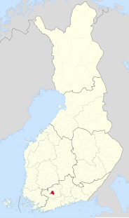
Renko is a former municipality of Finland. It was consolidated with Hämeenlinna on 2009-01-01.

The Sarayu is a river that flows through the Indian states of Uttarakhand and Uttar Pradesh. This river is of ancient significance, finding mentions in the Vedas and the Ramayana. The Sarayu river of India forms at the confluence of the Karnali and Mahakali in Bahraich District. The Mahakali or Sharda forms the western Indo-Nepal border. Ayodhya is situated on the banks of river Sarayu. Some mapmakers consider the Sarayu to be just a section of the lower Ghaghara River.

Zduny is a village in the administrative district of Gmina Opatówek, within Kalisz County, Greater Poland Voivodeship, in west-central Poland. It lies approximately 5 kilometres (3 mi) west of Opatówek, 7 km (4 mi) east of Kalisz, and 113 km (70 mi) south-east of the regional capital Poznań.
Szymanowice Duże is a village in Otwock County, Gmina Sobienie-Jeziory. The population is near 200.
Budzisk-Strużka is a settlement in the administrative district of Gmina Janów, within Sokółka County, Podlaskie Voivodeship, in north-eastern Poland.
Cieśnisk Mały is a village in the administrative district of Gmina Janów, within Sokółka County, Podlaskie Voivodeship, in north-eastern Poland. It lies approximately 7 kilometres (4 mi) north-east of Janów, 19 km (12 mi) north-west of Sokółka, and 45 km (28 mi) north of the regional capital Białystok.
Lipiny is a settlement in the administrative district of Gmina Secemin, within Włoszczowa County, Świętokrzyskie Voivodeship, in south-central Poland. It lies approximately 6 kilometres (4 mi) south-east of Secemin, 14 km (9 mi) south of Włoszczowa, and 53 km (33 mi) west of the regional capital Kielce.
Gleszczonek is a settlement in the administrative district of Gmina Wyrzysk, within Piła County, Greater Poland Voivodeship, in west-central Poland. It lies approximately 3 kilometres (2 mi) north-east of Wyrzysk, 37 km (23 mi) east of Piła, and 90 km (56 mi) north of the regional capital Poznań.
Gozdowo-Młyn is a settlement in the administrative district of Gmina Września, within Września County, Greater Poland Voivodeship, in west-central Poland. It lies approximately 9 kilometres (6 mi) south-east of Września and 53 km (33 mi) east of the regional capital Poznań.
Czajcze is a village in the administrative district of Gmina Krajenka, within Złotów County, Greater Poland Voivodeship, in west-central Poland. It lies approximately 4 kilometres (2 mi) south-east of Krajenka, 9 km (6 mi) south of Złotów, and 99 km (62 mi) north of the regional capital Poznań.
The Takla Range is a small subrange of the Skeena Mountains of the Interior Mountains, bounded by Takla Lake and Northwest Arm in northern British Columbia, Canada.
Dychlino is a settlement in the administrative district of Gmina Wicko, within Lębork County, Pomeranian Voivodeship, in northern Poland. It lies approximately 9 kilometres (6 mi) north of Wicko, 23 km (14 mi) north of Lębork, and 77 km (48 mi) north-west of the regional capital Gdańsk.
Kudyński Bór is a village in the administrative district of Gmina Pasłęk, within Elbląg County, Warmian-Masurian Voivodeship, in northern Poland. It lies approximately 9 kilometres (6 mi) south-east of Pasłęk, 26 km (16 mi) south-east of Elbląg, and 55 km (34 mi) north-west of the regional capital Olsztyn.
Stary Dwór is a settlement in the administrative district of Gmina Stawiguda, within Olsztyn County, Warmian-Masurian Voivodeship, in northern Poland. It lies approximately 10 kilometres (6 mi) north of Stawiguda and 7 km (4 mi) south-west of the regional capital Olsztyn.

Łagiewniki is a settlement in the administrative district of Gmina Resko, within Łobez County, West Pomeranian Voivodeship, in north-western Poland. It lies approximately 9 kilometres (6 mi) south-east of Resko, 15 km (9 mi) north-west of Łobez, and 71 km (44 mi) north-east of the regional capital Szczecin.
Dubininkas is a village in Varėna district municipality, in Alytus County, in southeastern Lithuania. According to the 2001 census, the village has a population of 5 people.

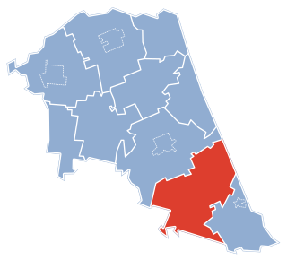
Brodar is a village in the municipality of Višegrad, Bosnia and Herzegovina.
Žlijeb is a village in the municipality of Višegrad, Bosnia and Herzegovina.
Lianmuqin is a town in Shanshan County, Xinjiang. It is located on China National Highway 312 about 20 km west of Shanshan Town, on the way to Turpan.