
Ellesmere Island is Canada's northernmost and third largest island, and the tenth largest in the world. It comprises an area of 196,236 km2 (75,767 sq mi), slightly smaller than Great Britain, and the total length of the island is 830 km (520 mi).

Grise Fiord is an Inuit hamlet on the southern tip of Ellesmere Island, in the Qikiqtaaluk Region, Nunavut, Canada. It is one of three populated places on the island; despite its low population, it is the largest community on Ellesmere Island. Created by the Canadian Government in 1953 through a relocation of Inuit families from Inukjuak, Quebec, it is Canada's northernmost public community. It is also one of the coldest inhabited places in the world, with an average yearly temperature of −16.5 °C (2.3 °F).
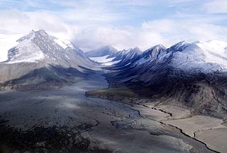
Quttinirpaaq National Park is located on the northeastern corner of Ellesmere Island in the Qikiqtaaluk Region of Nunavut, Canada. It is the second most northerly park on Earth after Northeast Greenland National Park. In Inuktitut, Quttinirpaaq means "top of the world". It was established as Ellesmere Island National Park Reserve in 1988, and the name was changed to Quttinirpaaq in 1999, when Nunavut was created, and became a national park in 2000. The reserve covers 37,775 km2 (14,585 sq mi), making it the second largest park in Canada, after Wood Buffalo National Park.

Eureka is a small research base on Fosheim Peninsula, Ellesmere Island, Qikiqtaaluk Region, in the Canadian territory of Nunavut. It is located on the north side of Slidre Fiord, which enters Eureka Sound farther west. It is the third-northernmost permanent research community in the world. The only two farther north are Alert, which is also on Ellesmere Island, and Nord, in Greenland. Eureka has the lowest average annual temperature and the lowest amount of precipitation of any weather station in Canada.

The Queen Elizabeth Islands are the northernmost cluster of islands in Canada's Arctic Archipelago, split between Nunavut and the Northwest Territories in Northern Canada. The Queen Elizabeth Islands contain approximately 14% of the global glacier and ice cap area. The southern islands are called the Parry Islands or Parry Archipelago.

Axel Heiberg Island is an uninhabited island in the Qikiqtaaluk Region, Nunavut, Canada. Located in the Arctic Ocean, it is the 32nd largest island in the world and Canada's seventh largest island. According to Statistics Canada, it has an area of 43,178 km2 (16,671 sq mi). It is named after Axel Heiberg.
Lake Hazen is a freshwater lake in the northern part of Ellesmere Island, Nunavut, Canada, north of the Arctic Circle. It is the largest lake north of the Arctic Circle by volume. By surface area it is third largest, after Lake Taymyr in Russia and Lake Inari in Finland.

The Arctic Cordillera is a terrestrial ecozone in northern Canada characterized by a vast, deeply dissected chain of mountain ranges extending along the northeastern flank of the Canadian Arctic Archipelago from Ellesmere Island to the northeasternmost part of the Labrador Peninsula in northern Labrador and northern Quebec, Canada. It spans most of the eastern coast of Nunavut with high glaciated peaks rising through ice fields and some of Canada's largest ice caps, including the Penny Ice Cap on Baffin Island. It is bounded to the east by Baffin Bay, Davis Strait and the Labrador Sea while its northern portion is bounded by the Arctic Ocean.
Hoved Island is part of the Qikiqtaaluk Region of the Canadian territory of Nunavut. The island is located between the Svendsen and Bjorne peninsulas, and within the Baumann Fiord of Ellesmere Island, considered part of the Queen Elizabeth Islands, in the Arctic Archipelago. It comprises an area of 158 km2 (61 sq mi).
The uninhabited Marvin Islands are located in the Arctic Ocean across the mouth of Disraeli Fiord, in northern Ellesmere Island within the Quttinirpaaq National Park. Ward Hunt Island lies to the northwest. The island group is a part of the Qikiqtaaluk Region, Nunavut, Canada.
Greely Fiord is a natural inlet in the west of Ellesmere Island, Qikiqtaaluk Region, Nunavut in the Arctic Archipelago. To the south lies the Cañon Fiord and the Agassiz Ice Cap. To the northwest is Borup Fiord and Tanquary Fiord is northeast.
Brae Bay is an Arctic waterway in the Qikiqtaaluk Region, Nunavut, Canada. It is located in Jones Sound by northern Devon Island, just north of the Devon Ice Cap and 12 km (7.5 mi) north of the Sverdrup Glacier (75°40′40″N83°16′20″W}.
Buchanan Bay is an Arctic waterway in Qikiqtaaluk Region, Nunavut, Canada. It is located in Nares Strait by eastern Ellesmere Island. The bay is bordered by Cape Camperdown on Bache Peninsula to the north, Cape Rutherford on Johan Peninsula to the south, and the Alexandra Fiord at its head.

Craig Harbour is an abandoned settlement in the Qikiqtaaluk Region, Nunavut, Canada. It is located on Ellesmere Island, on the north shore of Jones Sound, 55 km (34 mi) southeast of Grise Fiord.

Tanquary Fiord is a fjord on the north coast of the Arctic Archipelago's Ellesmere Island, Nunavut, Canada. It is located in the Quttinirpaaq National Park and extends 48 km (30 mi) in a north-westerly direction from Greely Fiord.
Strathcona Fiord is a fiord on the west central coast of Ellesmere Island, the most northern island within the Arctic Archipelago, Nunavut, Canada.
Borup Fiord is located on Ellesmere Island, Qikiqtaaluk Region, Nunavut Canada. The mouth of the fiord opens into Greely Fiord. To the west is Oobloyah Bay and to the north is the Neil Peninsula and the Neil Icecap. The eastern arm, known as Esayoo Bay leads to Borup Fiord Pass. Detailed studies of the Borup Fiord area between Oobloyah Bay and Esayoo Bay have been done in summer 1988 by geographers from Heidelberg University.
Kangiqtualuk Uqquqti formerly Sam Ford Fiord is an isolated, elongated Arctic fjord on Baffin Island's northeastern coast in the Qikiqtaaluk Region of Nunavut, Canada. The Inuit settlement of Pond Inlet is 320 km (200 mi) to the northwest and Clyde River is 80 km (50 mi) to the east.
Arviqtujuq Kangiqtua formerly Eglinton Fiord is a fjord on Baffin Island's northeastern coast in the Qikiqtaaluk Region of Nunavut, Canada. The Inuit settlement of Pond Inlet is 355 km (221 mi) to the northwest and Clyde River is 55 km (34 mi) to the east.
Grise Fiord is a fjord on Ellesmere Island, Qikiqtaaluk Region, Nunavut, Canada. Grise Fiord means "pig inlet" in Norwegian. Otto Sverdrup from Norway named it so during an expedition around 1900 because he thought the walrus in the area sounded like pigs. It feeds into Jones Sound and out into Baffin Bay. The Inuit community of Grise Fiord, the northernmost civilian settlement in Canada, is located at the south end of the fiord.
