
Highway 20, also known as the Chilcotin Highway, and officially dubbed the Alexander MacKenzie Highway, is one of the two main east–west routes in the Central Interior of British Columbia (the other being Highway 16. The Chilcotin Highway runs 457 km from Williams Lake westward through the Chilcotin region to North Bentinck Arm, an inlet from the Pacific Ocean where the town of Bella Coola is located. As of 2019, all but 42 km has been paved, mostly for expediting the removal of timber from the region, which, like most of British Columbia, is afflicted with pine beetle infestations. Logging traffic and ranch-related traffic on the route can be expected.
The Tsilhqotʼin or Chilcotin are a North American tribal government of the Athabaskan-speaking ethnolinguistic group that live in what is now known as British Columbia, Canada. They are the most southern of the Athabaskan-speaking Indigenous peoples in British Columbia.
The Chilcotin region of British Columbia is usually known simply as "the Chilcotin", and also in speech commonly as "the Chilcotin Country" or simply Chilcotin. It is a plateau and mountain region in British Columbia on the inland lee of the Coast Mountains on the west side of the Fraser River. Chilcotin is also the name of the river draining that region. In the language of the Tsilhqot'in people, their name and the name of the river means "those of the red ochre river". The proper name of the Chilcotin Country, or Tsilhqotʼin territory, in their language is Tŝilhqotʼin Nen.

The Chilcotin River /tʃɪlˈkoʊtɪn/ located in Southern British Columbia, Canada is a 241 km (150 mi) long tributary of the Fraser River. The name Chilcotin comes from Tŝilhqot’in, meaning "ochre river people," where ochre refers to the mineral used by Tŝilhqot’in Nation and other Indigenous communities as a base for paint or dye. The Chilcotin River, Chilko River and Lake, and Taseko River and Lake make up the Chilcotin River watershed. This 19,200 km2 (7,400 sq mi) watershed drains the Chilcotin Plateau which reaches north to south from the Nechako Plateau to Bridge River county and east to west from Fraser River to the Coast Mountains. It is also one of twelve watersheds that make up the Fraser River Basin. Made up of seven major tributaries, Chilcotin River starts northeast of Itcha Mountain, flowing southeast until it joins the Fraser River south of Williams Lake, 22 km (14 mi) upstream from Gang Ranch.
Bull Canyon Provincial Park is a provincial park in British Columbia, Canada, protecting Bull Canyon on the Chilcotin River, which is 7 km (4 mi) below the confluence of the Chilko River with the Chilcotin. The canyon and park are located just west of the community of Alexis Creek. Bull Canyon is part of a large volcanic plateau called the Chilcotin Group.

Roberts Creek is a community on the southern Sunshine Coast, in British Columbia, Canada, and within Electoral Area D of the Sunshine Coast Regional District.

The British Columbia Interior, popularly referred to as the BC Interior or simply the Interior, is a geographic region of the Canadian province of British Columbia. While the exact boundaries are variously defined, the British Columbia Interior is generally defined to include the 14 regional districts that do not have coastline along the Pacific Ocean or Salish Sea, and are not part of the Lower Mainland. Other boundaries may exclude parts of or even entire regional districts, or expand the definition to include the regional districts of Fraser Valley, Squamish–Lillooet, and Kitimat–Stikine.
The Carrier-Chilcotin Tribal Council is a First Nations tribal council located in the Chilcotin District of the Central Interior of the Canadian province of British Columbia, and also on the Fraser River near the city of Quesnel. It consists of three Carrier bands and one Tsilhqot'in band. The other Tsilhqot'in bands belong to the Tsilhqot'in National Government. Most other Carrier bands are either unaffiliated or belong to the Carrier-Sekani Tribal Council. The Tribal Council's offices are in Williams Lake.
The Tŝideldel First Nation is the band government of the Tsi Del Del subgroup of the Tsilhqot'in people, located in the Chilcotin District in the western Central Interior region of the Canadian province of British Columbia. It is a member of the Tsilhqot'in National Government.
The Tlʼetinqox-tʼin Government Office is a First Nations government located in the Chilcotin District in the western Central Interior region of the Canadian province of British Columbia. Governing a reserve communities near Alexis Creek known as Anaham Reserve First Nations or Anaham, it is a member of the Tsilhqotʼin Tribal Council aka known as the Tsilhqotʼin National Government. The main reserve is officially known as Anahim's Flat No. 1, and is more commonly as Anaham. Other reserves are Anahim's Meadow No. 2 and 2A, and Anahim Indian Reserves Nos. 3 through 18. Anaham, or Anahim and Alexis were chiefs of the Tsilhqotʼin during the Chilcotin War of 1864, although they and their people did not take part in the hostilities.
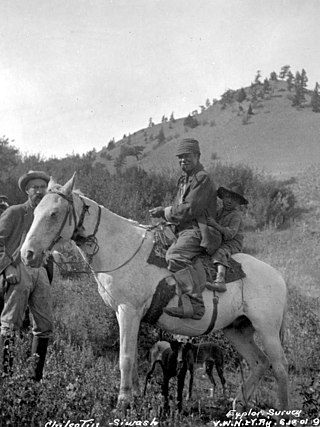
The Tlʼetinqox-tʼin are a First Nations people in the Chilcotin District of the Canadian province of British Columbia. They are a subgroup of the Tsilhqotʼin people and reside near the community of Alexis Creek, an unincorporated settlement and Indian Reserve community on Highway 20 near Riske Creek.

The Tsilhqotʼin National Government (TNG), is the official First Nations government serving the Tsilhqotʼin Nation. Their office is located in Williams Lake, British Columbia, Canada. The member communities represented by TNG are ʔEsdilagh, Tsi Del Del, Yunesitʼin, Tlʼetinqox, Xeni Gwetʼin, and Tlʼesqox. Tlʼesqox also belongs to the Carrier-Chilcotin Tribal Council, as does Ulkatcho - a community with both Dakelh (Carrier) & Tsilhqotʼin heritage. TNG was established in 1989.
Tatla Lake is a small unincorporated community in the west Chilcotin area of British Columbia, Canada, located at the west end of its eponymous lake. Situated 220 km west of Williams Lake along Highway 20, Tatla Lake's 123 people live approximately halfway between the two ends of the highway; Williams Lake to the east and the coastal community of Bella Coola to the west. The community is the service centre for three major mountain valleys of West Branch, Chilko and Tatlayoko. These valleys extend southward via secondary roads.
Cheẑichʼed Biny, known as Chilcotin Lake, is a lake in the Chilcotin District of the Central Interior of British Columbia, Canada. It is located on the Chilcotin River to the north of Puntzi Lake.
Chilanko Forks is an unincorporated settlement as well as a First Nations community of the Tsilhqot'in people, located on the north bank of the Chilanko River just northeast of Tatla Lake, and immediately south of Puntzi Lake, in the Chilcotin District of the Central Interior of British Columbia. Chilanko Forks is the location of the offices of the Alexis Creek First Nation.
Hanceville is about 90 km west of Williams Lake in the Chilcotin District of the Central Interior of British Columbia, Canada. It is the main community of the Stone First Nation band. It is located southeast of Alexis Creek, on the north side of the Chilcotin River.
Tŝideldel, also called Redstone, is an unincorporated settlement and First Nations community of the Tsilhqot'in people, located near Chilanko Forks in the Chilcotin District of the Central Interior of British Columbia, Canada. Located on the Chilanko River, it should not be confused with the locality also called Redstone, 16 km to the east, located at the confluence of the Chilanko and Chilcotin Rivers,. It includes Redstone Flat Indian Reserve No. 1, Redstone Flat Indian Reserve No. 1A, and Redstone Cemetery Indian Reserve No. 1B, all under the administration of the Alexis Creek First Nation.
Chezacut is an unincorporated ranching settlement and former post office in the Chilcotin District of the Central Interior of British Columbia, Canada. Its name means "bird without wings" in the Chilcotin language. It is located on the north shore of Chilcotin Lake near the confluence of the Chilcotin and Clusko Rivers, 43 kilometers northwest of the community of Alexis Creek.
Anaham or Tletinqox is an unincorporated settlement and First Nations community of the Tsilhqot'in people, located near Alexis Creek in the Chilcotin District of the Central Interior of British Columbia, Canada and a 19th-century chief of the Tsilhqot'in people of British Columbia. In modern use it may refer to:

On July 6, 2017, a two-hectare wildfire began west of 100 Mile House, British Columbia, Canada marking the beginning of the record-breaking 2017 wildfire season in British Columbia. On July 7, 56 new fires started throughout British Columbia (BC) leading to several evacuation alerts, orders and the declaration of a provincial state of emergency by the Government of British Columbia. By September 12, 158 fires were burning throughout the province. A total of 12,161 square kilometres had burned by the end of the 2017 fire season, the largest total area burned in a fire season in recorded history. This record was broken the following year, with five of BC's worst 10 fire seasons occurring since 2010. However, the 2017 fire season was also notable for the largest number of total evacuees in a fire season, as well as for the largest single fire ever in British Columbia. Research indicates that human-caused climate change played a significant role in the fires.