Related Research Articles

The Tsilhqotʼin or Chilcotin are a North American tribal government of the Athabaskan-speaking ethnolinguistic group that live in what is now known as British Columbia, Canada. They are the most southern of the Athabaskan-speaking Indigenous peoples in British Columbia.

The Chilcotin River /tʃɪlˈkoʊtɪn/ located in Southern British Columbia, Canada is a 241 km (150 mi) long tributary of the Fraser River. The name Chilcotin comes from Tŝilhqot’in, meaning "ochre river people," where ochre refers to the mineral used by Tŝilhqot’in Nation and other Indigenous communities as a base for paint or dye. The Chilcotin River, Chilko River and Lake, and Taseko River and Lake make up the Chilcotin River watershed. This 19,200 km2 (7,400 sq mi) watershed drains the Chilcotin Plateau which reaches north to south from the Nechako Plateau to Bridge River county and east to west from Fraser River to the Coast Mountains. It is also one of twelve watersheds that make up the Fraser River Basin. Made up of seven major tributaries, Chilcotin River starts northeast of Itcha Mountain, flowing southeast until it joins the Fraser River south of Williams Lake, 22 km (14 mi) upstream from Gang Ranch.

The Chilko River is a 75-kilometre-long (47 mi) river in the Chilcotin District of the Central Interior of British Columbia, Canada, flowing northeast from Chilko Lake to the Chilcotin River. Its main tributary is the Taseko River.

The Homathko River is one of the major rivers of the southern Coast Mountains of the Canadian province of British Columbia. It is one of the few rivers that penetrates the range from the interior Chilcotin Country to the coastal inlets of the Pacific Ocean. The Homathko River reaches the sea at the head of Bute Inlet, just west of the mouth of the Southgate River.
The Klinaklini River is one of the major rivers of the Pacific Ranges section of the Coast Mountains in the Canadian province of British Columbia. It originates in the Pantheon Range and empties into the head of Knight Inlet.

The West Road River or Blackwater River or Tiyakoh is an important tributary of the Fraser River, flowing generally north-eastward from the northern slopes of the Ilgachuz Range and across the Fraser Plateau in the Chilcotin region of central British Columbia, Canada. With only one major tributary, the Nazko River, its confluence with the Fraser is approximately 40 km northwest of Quesnel. It forms the division between the Chilcotin Plateau (S) and the Nechako Plateau (N), which are subdivisions of the Fraser Plateau.
Big Creek is a roughly 120-kilometre (75 mi) long tributary of British Columbia's Chilcotin River.
The Chilcotin War, the Chilcotin Uprising or the Bute Inlet Massacre was a confrontation in 1864 between members of the Tsilhqot'in (Chilcotin) people in British Columbia and white road construction workers. Fourteen men employed by Alfred Waddington in the building of a road from Bute Inlet were killed, as well as a number of men with a pack-train near Anahim Lake and a settler at Puntzi Lake.
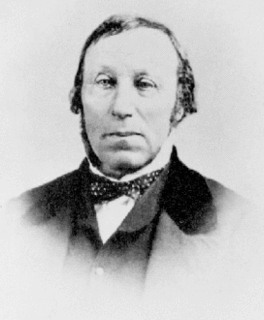
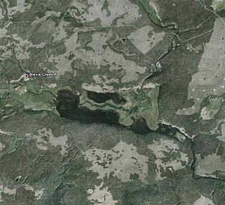
Alexis Creek is an unincorporated community in the Chilcotin District of the western Central Interior of the Canadian province of British Columbia, on Highway 20 between Williams Lake and Bella Coola. The creek is named, like the adjacent lake of the same name, for a colonial-era chief of the Tsilhqot'in people, Alexis, who figured in the story of the Chilcotin War of 1864.
The Carrier-Chilcotin Tribal Council is a First Nations tribal council located in the Chilcotin District of the Central Interior of the Canadian province of British Columbia, and also on the Fraser River near the city of Quesnel. It consists of three Carrier bands and one Tsilhqot'in band. The other Tsilhqot'in bands belong to the Tsilhqot'in National Government. Most other Carrier bands are either unaffiliated or belong to the Carrier-Sekani Tribal Council. The Tribal Council's offices are in Williams Lake.
ʔEsdilagh is a First Nation community in the North Cariboo region of British Columbia, Canada. It is the smallest of the six member communities that form the Tsilhqot'in National Government. Formerly, the people of this region were known as ʔElhdaqox-t'in, the people of the Sturgeon River. Today, the community goes by the name ʔEsdilagh, which in Tŝilhqot'in language means peninsula.
The Tŝideldel First Nation is the band government of the Tsi Del Del subgroup of the Tsilhqot'in people, located in the Chilcotin District in the western Central Interior region of the Canadian province of British Columbia. It is a member of the Tsilhqot'in National Government.
The Stone First Nation or Yunesit'in First Nation is a band government of the Yunesit'in subgroup of the Tsilhqot'in people, whose territory is the Chilcotin District in the western Central Interior region of the Canadian province of British Columbia. It is a member of the Tsilhqot'in Tribal Council. The people of the Stone First Nation are known as the Yunesit'in in the Chilcotin language.
William George Cox was Gold Commissioner for the Cariboo and Boundary Districts in the Colony of British Columbia, Canada during the Rock Creek Gold Rush. He was born in Ireland.
The Tsilhqot'in National Government (TNG), is the official First Nations government serving the Tsilhqot'in Nation. Their office is located in Williams Lake, British Columbia, Canada. The member communities represented by TNG are ʔEsdilagh, Tsi Del Del, Yunesit'in, Tl'etinqox, Xeni Gwet'in, and Tl'esqox. Tl'esqox also belongs to the Carrier-Chilcotin Tribal Council, as does Ulkatcho - a community with both Dakelh (Carrier) & Tsilhqot'in heritage. TNG was established in 1989.
The Chilanko River is a river in the Chilcotin region of the Central Interior region of the Canadian province of British Columbia.
Cheẑich’ed Biny, known as Chilcotin Lake, is a lake in the Chilcotin District of the Central Interior of British Columbia, Canada. It is located on the Chilcotin River to the north of Puntzi Lake.
Puntzi Lake is a lake in the Chilcotin District of the Central Interior of British Columbia. It is located on the western side of the upper Chilcotin River to the northeast of Tatla Lake, and is connected to the Chilcotin River via Puntzi Creek, of which it is an expansion. The area around the lake has been the setting for many important events in the history of the region.
Anaham or Tletinqox is an unincorporated settlement and First Nations community of the Tsilhqot'in people, located near Alexis Creek in the Chilcotin District of the Central Interior of British Columbia, Canada and a 19th-century chief of the Tsilhqot'in people of British Columbia. In modern use it may refer to:
Mosely Creek is a large creek in the Pacific Ranges of the Coast Mountains in British Columbia, Canada, flowing southwest to join the Homathko River in its canyon downstream from Tatlayoko Lake, and a short distance above Murderers Bar at 51°16′00″N124°54′00″W, which is the site of the opening events of the Chilcotin War of 1864.
References
- ↑ Source elevation derived from Google Earth.
- ↑ Mouth elevation derived from Google Earth.
- ↑ "Alexis Creek". BC Geographical Names .
- ↑ Journals of Governor Seymour, quoted in 1001 British Columbia Place Names, Akrigg, Helen B. and Akrigg, G.P.V, Discovery Press, Vancouver 1969, 1970, 1973