
Hydrology is the scientific study of the movement, distribution, and management of water on Earth and other planets, including the water cycle, water resources, and drainage basin sustainability. A practitioner of hydrology is called a hydrologist. Hydrologists are scientists studying earth or environmental science, civil or environmental engineering, and physical geography. Using various analytical methods and scientific techniques, they collect and analyze data to help solve water related problems such as environmental preservation, natural disasters, and water management.
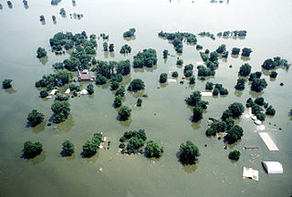
A 100-year flood is a flood event that has on average a 1 in 100 chance of being equaled or exceeded in any given year.

A culvert is a structure that channels water past an obstacle or to a subterranean waterway. Typically embedded so as to be surrounded by soil, a culvert may be made from a pipe, reinforced concrete or other material. In the United Kingdom, the word can also be used for a longer artificially buried watercourse.
Flood forecasting is the process of predicting the occurrence, magnitude, timing, and duration of floods in a specific area, often by analysing various hydrological, meteorological, and environmental factors. The primary goal of flood forecasting is to deliver timely and accurate information to decision-makers, empowering them to take appropriate actions to mitigate the potential consequences of flooding on human lives, property, and the environment. By accounting for the various dimensions of a flood event, such as occurrence, magnitude, duration, and spatial extent, flood forecasting models can offer a more holistic and detailed representation of the impending risks and facilitate more effective response strategies.
The United States Environmental Protection Agency (EPA) Storm Water Management Model (SWMM) is a dynamic rainfall–runoff–subsurface runoff simulation model used for single-event to long-term (continuous) simulation of the surface/subsurface hydrology quantity and quality from primarily urban/suburban areas.

Surface runoff is the unconfined flow of water over the ground surface, in contrast to channel runoff. It occurs when excess rainwater, stormwater, meltwater, or other sources, can no longer sufficiently rapidly infiltrate in the soil. This can occur when the soil is saturated by water to its full capacity, and the rain arrives more quickly than the soil can absorb it. Surface runoff often occurs because impervious areas do not allow water to soak into the ground. Furthermore, runoff can occur either through natural or human-made processes.

An hydrological transport model is a mathematical model used to simulate the flow of rivers, streams, groundwater movement or drainage front displacement, and calculate water quality parameters. These models generally came into use in the 1960s and 1970s when demand for numerical forecasting of water quality and drainage was driven by environmental legislation, and at a similar time widespread access to significant computer power became available. Much of the original model development took place in the United States and United Kingdom, but today these models are refined and used worldwide.
Environmental flows describe the quantity, timing, and quality of water flows required to sustain freshwater and estuarine ecosystems and the human livelihoods and well being that depend on these ecosystems. In the Indian context river flows required for cultural and spiritual needs assumes significance. Through implementation of environmental flows, water managers strive to achieve a flow regime, or pattern, that provides for human uses and maintains the essential processes required to support healthy river ecosystems. Environmental flows do not necessarily require restoring the natural, pristine flow patterns that would occur absent human development, use, and diversion but, instead, are intended to produce a broader set of values and benefits from rivers than from management focused strictly on water supply, energy, recreation, or flood control.
Groundwater models are computer models of groundwater flow systems, and are used by hydrologists and hydrogeologists. Groundwater models are used to simulate and predict aquifer conditions.

A hydrologic model is a simplification of a real-world system that aids in understanding, predicting, and managing water resources. Both the flow and quality of water are commonly studied using hydrologic models.

A stream is a continuous body of surface water flowing within the bed and banks of a channel. Depending on its location or certain characteristics, a stream may be referred to by a variety of local or regional names. Long, large streams are usually called rivers, while smaller, less voluminous and more intermittent streams are known as streamlets, brooks or creeks.
GSSHA is a two-dimensional, physically based watershed model developed by the Engineer Research and Development Center of the United States Army Corps of Engineers. It simulates surface water and groundwater hydrology, erosion and sediment transport. The GSSHA model is used for hydraulic engineering and research, and is on the Federal Emergency Management Agency (FEMA) list of hydrologic models accepted for use in the national flood insurance program for flood hydrograph estimation. Input is best prepared by the Watershed Modeling System interface, which effectively links the model with geographic information systems (GIS).
Hydrological optimization applies mathematical optimization techniques to water-related problems. These problems may be for surface water, groundwater, or the combination. The work is interdisciplinary, and may be done by hydrologists, civil engineers, environmental engineers, and operations researchers.
The following outline is provided as an overview of and topical guide to hydrology:
Vflo is a commercially available, physics-based distributed hydrologic model generated by Vieux & Associates, Inc. Vflo uses radar rainfall data for hydrologic input to simulate distributed runoff. Vflo employs GIS maps for parameterization via a desktop interface. The model is suited for distributed hydrologic forecasting in post-analysis and in continuous operations. Vflo output is in the form of hydrographs at selected drainage network grids, as well as distributed runoff maps covering the watershed. Model applications include civil infrastructure operations and maintenance, stormwater prediction and emergency management, continuous and short-term surface water runoff, recharge estimation, soil moisture monitoring, land use planning, water quality monitoring, and water resources management.
A water year is a term commonly used in hydrology to describe a time period of 12 months for which precipitation totals are measured. Its beginning differs from the calendar year because part of the precipitation that falls in late autumn and winter accumulates as snow and does not drain until the following spring or summer's snowmelt. The goal is to ensure that as much as possible of the surface runoff during the water year is attributable to the precipitation during the same water year.
In hydrology, routing is a technique used to predict the changes in shape of a hydrograph as water moves through a river channel or a reservoir. In flood forecasting, hydrologists may want to know how a short burst of intense rain in an area upstream of a city will change as it reaches the city. Routing can be used to determine whether the pulse of rain reaches the city as a deluge or a trickle.
Amir AghaKouchak is an Iranian American civil engineer, academic and researcher. He is a Professor of Civil Engineering, Environmental Engineering, and Earth System Science at University of California, Irvine.

Watershed delineation is the process of identifying the boundary of a watershed, also referred to as a catchment, drainage basin, or river basin. It is an important step in many areas of environmental science, engineering, and management, for example to study flooding, aquatic habitat, or water pollution.

Ezio Todini is an Italian academic, hydrologist and civil engineer.