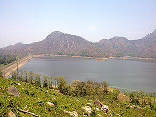
Pothundi Dam is an irrigation dam near Pothundi village in the Palakkad district of Kerala state, India. Constructed in the 19th century, it is considered one of the oldest dams in India. It provides irrigation to an area of 5,470 hectares in the Palakkad district and drinking water supply to the Nemmara, Ayalur, Melarcode Panchayat. An unusual feature of the earth dam is the core wall, which is built with a mixture of jaggery and quick lime.

The Sainte-Anne River is a tributary of the north shore of the Saint Lawrence River, whose mouth is located at Sainte-Anne-de-la-Pérade. This river flows in the province of Quebec, Canada, in the administrative regions of:

Malmsjøen is a lake in the municipality of Skaun in Trøndelag county, Norway. It is located about 1.5 kilometres (0.93 mi) southeast of the village of Skaun, about 7 kilometres (4.3 mi) north of the village of Korsvegen, and about 10 kilometres (6.2 mi) southwest of the village of Melhus. The Norwegian County Road 709 runs along the northern shore of the lake.
Byavatnet is a lake in the municipality of Levanger in Trøndelag county, Norway. It is located about 2.5 kilometres (1.6 mi) south of the village of Ekne and about 3 kilometres (1.9 mi) west of the village of Ronglan. The lake Hammervatnet lies about 3.5 kilometres (2.2 mi) south of Byavatnet and the lake Sønningen lies about 1.5 kilometres (0.93 mi) to the northwest. The 2.31-square-kilometre (570-acre) lake is about 5 kilometres (3.1 mi) long and about 800 metres (0.5 mi) wide.

Viddalsdammen is a lake and a reservoir in Aurland Municipality in Vestland county, Norway. The reservoir has an area of 4.13-square-kilometre (1.59 sq mi) and the elevation varies between 930 metres (3,050 ft) and 868 m (2,848 ft) above sea level. Viddalsdammen is located at the end of the Låvisdalen valley, about 11 kilometres (6.8 mi) southeast of the village of Aurlandsvangen, about 7 kilometres (4.3 mi) southeast of the village of Flåm, and about 6 kilometres (3.7 mi) northeast of Myrdal Station.
Highway 3 is a major provincial paved undivided highway in the Canadian province of Saskatchewan. It runs from the Alberta border, where it continues west as Alberta Highway 45, to the Manitoba border, and then continues east as Highway 77. Highway 3 is about 615 km (382 mi.) long. The CanAm Highway comprises Saskatchewan Highways 35, 39, 6, 3, as well as 2. 59.7 miles (96.1 km) of Saskatchewan Highway 3 contribute to the CanAm Highway between Melfort and Prince Albert.

Ancuabe District is a district of Cabo Delgado Province in northern Mozambique. It covers 4,984 km2 with 199,457 inhabitants in 2015. Its seat is the town of Ancuabe.

The Big Black River is a river crossing the administrative region of Chaudière-Appalaches in Quebec and in Maine. From its source, in L'Islet RCM, Quebec, the river runs northeast and east across the Canada–United States border in Maine Township 14, Range 16, WELS, to the Saint John River in Northwest Aroostook T 15, R 13.
The Daaquam River is a river primarily flowing in the administrative region of Chaudière-Appalaches, at South of Quebec in Canada and northern Maine, in United States. The river runs from its source, south of Sainte-Justine, northeast across the Canada–United States border to the Northwest Branch of the Saint John River in Maine.
The Shields Branch is a tributary of the Big Black River), flowing in:
The Southwest Branch Saint John River is a 62.0-mile-long (99.8 km) river in Maine and Quebec. The branch originates in "Little Saint John Lake" on the international boundary between Saint-Zacharie, Quebec and Seboomook Lake Township 5, Range 20, WELS. The branch forms the Canada–United States border as it flows northeasterly to a confluence with the Little Southwest Branch Saint John River in Seboomook Lake Township 9, Range 18, WELS. The Southwest Branch flows briefly into Quebec and then through Maine to its confluence with the Baker Branch Saint John River in Seboomook Lake Township 9, Range 17, WELS. The Southwest Branch finally joins with the Northwest Branch to form the Saint John River.

Sematan is a settlement in the Lundu district of Sarawak, Malaysia. It lies approximately 67.5 kilometres (42 mi) west-north-west of the state capital Kuching.

Ninam is a census village in Satara district, in the Indian state of Maharashtra. It is a village surrounded by greenery and farms but also mountains. Agriculture is the main land use in the village with more than 75% of the total area being used for agricultural activities. The village close to historic Ajinkyatara fort, which is to the north. The large Jyotirlinga temple is in the center of the village.
The Upsalquitch Northwest River is a tributary of the South bank of the Upsalquitch River, crossing the parishes of Saint-Quentin, Eldon and Addington, in Restigouche County, in the northwest of New Brunswick, in Canada.
The River Gounamitz is a tributary of the head of the Restigouche River, flowing in the Northwest of New Brunswick, in Canada.

Dhuleta is a village in Phillaur tehsil of Jalandhar District of Punjab State, India. It is located 1 kilometre (0.62 mi) away from postal head office Bara Pind. The village is 6.4 kilometres (4.0 mi) away from Apra, 38.5 kilometres (23.9 mi) from Jalandhar, and 125 kilometres (78 mi) from state capital Chandigarh. The village is administrated by a sarpanch who is an elected representative of village as per Panchayati raj (India).
The Otter River is a tributary of the Northwest Branch Saint John River, flowing in Quebec (Canada) and in Maine. This river crosses the following administrative territories:
The Gobeil River is a tributary of the Big Black River, flowing through:
The Little Iroquois River is a tributary of the Iroquois River, flowing in Notre Dame Mountains, the Madawaska County, in Northwest of New Brunswick, in Canada.

The Opawica River is a tributary of the Waswanipi River, which is a tributary of Matagami Lake which in turn flows into the Nottaway River which flows into the south of James Bay. The Opawica River flows in the municipality of Eeyou Istchee Baie-James (municipality), in the administrative region of Nord-du-Québec, in Quebec, the Canada.