Ilm-Kreis is a district in Thuringia, Germany. It is bounded by the city of Erfurt, the districts of Weimarer Land, Saalfeld-Rudolstadt and Hildburghausen, the city of Suhl, and the districts of Schmalkalden-Meiningen and Gotha. It is named after the river Ilm, flowing through the district.
Uder is a municipality in the district of Eichsfeld in Thuringia, Germany. On 1 January 2024, the former municipality Uder was merged with the former municipalities Birkenfelde, Eichstruth, Lenterode, Lutter, Mackenrode, Röhrig, Schönhagen, Steinheuterode, Thalwenden and Wüstheuterode to form the current municipality Uder.

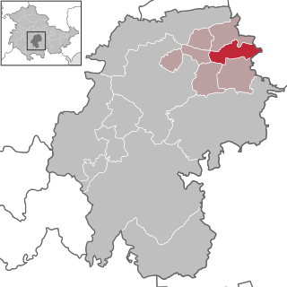
Neundorf (bei Schleiz) is a municipality in the district of Saale-Orla, Thuringia, Germany.

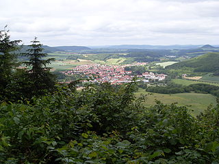
Arnstadt is a town in Ilm-Kreis, Thuringia, Germany, on the river Gera about 20 kilometres (12 mi) south of Erfurt, the capital of Thuringia. Arnstadt is one of the oldest towns in Thuringia, and has a well-preserved historic centre with a partially preserved town wall. The town is nicknamed Das Tor zum Thüringer Wald because of its location on the northern edge of that forest. Arnstadt has a population of approximately 27,000.

Dobitschen is a municipality in the Altenburger Land district, in the far eastern part of Thuringia, Germany. It borders on the municipalities Schmölln, Göllnitz, Mehna and Starkenberg. It is subdivided into the Ortsteile Dobitschen, Meucha, Pontewitz and Rolika.
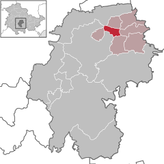
Plaue is a town in the Ilm-Kreis district, in Thuringia, Germany. It is situated on the river Gera, 11 km north of Ilmenau, and 8 km southwest of Arnstadt. The former municipality Neusiß was merged into Plaue in January 2019. Plaue station lies on the Neudietendorf–Ritschenhausen railway.

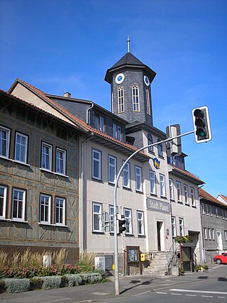
Stadtilm is a town in the Ilm-Kreis district, in Thuringia, Germany. It is situated on the river Ilm, 15 km northeast of Ilmenau, and 11 km southeast of Arnstadt. In July 2018 the former municipality of Ilmtal was merged into Stadtilm.
Berka vor dem Hainich is a municipality in the Wartburgkreis district of Thuringia, Germany.

Oechsen is a municipality in the Wartburgkreis district of Thuringia, Germany.

Elxleben is a municipality in the Sömmerda district of Thuringia, Germany.

Eschenbergen is a municipality in the district of Gotha, in Thuringia, Germany.

Dornheim is a municipality in the district Ilm-Kreis, in Thuringia, Germany.

Elxleben is a municipality in the district Ilm-Kreis, in Thuringia, Germany.
Osthausen-Wülfershausen is a municipality in the district Ilm-Kreis, in Thuringia, Germany.

Graitschen bei Bürgel is a municipality in the district Saale-Holzland, in Thuringia, Germany.

Kaulsdorf is a municipality in the district Saalfeld-Rudolstadt, in Thuringia, Germany.

Lausnitz is a municipality in the district Saale-Orla-Kreis, in Thuringia, Germany. It lies 4 km west of Neustadt an der Orla.

Unterwellenborn is a municipality in the district Saalfeld-Rudolstadt, in Thuringia, Germany. It was created on 1 February 2006 by fusion of the municipalities Birkigt, Goßwitz, Könitz, Lausnitz bei Pößneck and Unterwellenborn itself which had cooperated earlier as Verwaltungsgemeinschaft Unterwellenborn. Already on 9 April 1994, the municipalities Dorfkulm, Langenschade and Oberwellenborn had become part of the municipality of Unterwellenborn. In July 2018 the former municipality of Kamsdorf was merged into Unterwellenborn.

Rosenthal am Rennsteig is a municipality in the district Saale-Orla-Kreis, in Thuringia, Germany. It was created with effect from 1 January 2019 by the merger of the former municipalities of Birkenhügel, Blankenberg, Blankenstein, Harra, Neundorf bei Lobenstein, Pottiga and Schlegel.
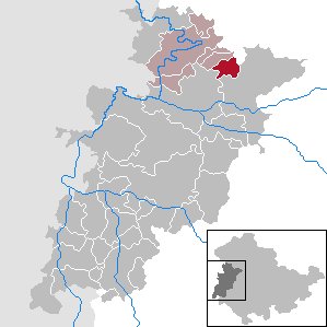
Ilm-Kreis II is an electoral constituency represented in the Landtag of Thuringia. It elects one member via first-past-the-post voting. Under the current constituency numbering system, it is designated as constituency 23. It covers the northern and western part of Ilm-Kreis.