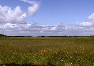
Alligator Lake is located in central Columbia County, Florida, United States. [1]

Alligator Lake is located in central Columbia County, Florida, United States. [1]
In 1835, it was reported that Alligator Lake, also known as Alligator Basin, was a prairie or savanna and was used by the local Native Americans as pasture land. The lake was reported as dry in the fall of 1891 and the fall of 1899, both years with below average rainfall. It was also dry in the winter and spring of 1909 and during the summer of 1909, the lake once again partially filled. [2] [3]

Columbia County is a county located in the north central portion of the U.S. state of Florida. As of the 2020 census, the population was 69,698, up from 67,531 at the 2010 census. Its county seat is Lake City.

The Everglades is a natural region of tropical wetlands in the southern portion of the U.S. state of Florida, comprising the southern half of a large drainage basin within the Neotropical realm. The system begins near Orlando with the Kissimmee River, which discharges into the vast but shallow Lake Okeechobee. Water leaving the lake in the wet season forms a slow-moving river 60 miles (97 km) wide and over 100 miles (160 km) long, flowing southward across a limestone shelf to Florida Bay at the southern end of the state. The Everglades experiences a wide range of weather patterns, from frequent flooding in the wet season to drought in the dry season. Throughout the 20th century, the Everglades suffered significant loss of habitat and environmental degradation.

Keystone Heights is a city located in southwestern Clay County, Florida, United States. The population of the city was 1,446 at the 2020 census and increased to 1,478 in 2021. The city's name is derived from the state of Pennsylvania's nickname, the "Keystone State". Keystone Heights is the southwestern most city in the Jacksonville metropolitan area, home to 1,637,666 residents.

Lake City is a city in and the county seat of Columbia County, Florida, United States. As of the 2020 census, the city's population was 12,329. It is the principal city of the Lake City Micropolitan Statistical Area, which is composed of Columbia County, and had a 2010 population of 67,531. Lake City is 60 miles west of Jacksonville.

Whitefish Township is a civil township of Chippewa County in the U.S. state of Michigan. The population was 575 at the 2010 census.

Adams Township is a civil township of Houghton County in the U.S. state of Michigan. As of the 2020 census, the township population was 2,540.

The Kissimmee River is a river in south-central Florida, United States that forms the north part of the Everglades wetlands area. The river begins at East Lake Tohopekaliga south of Orlando, flowing south through Lake Kissimmee into the large, shallow Lake Okeechobee. Hurricane-related floods in 1947 prompted channelization of the meandering lower stretch, completed by 1970. The straightened course reduced wetland habitat and worsened pollution. In response, efforts since the 1990s have partially restored the river's original state and revitalized the ecosystem, as part of the broader restoration of the Everglades.

The East Bay River in Florida is a 15-mile-long (24 km) river located in Santa Rosa and Okaloosa counties. It flows from east to west, forming near Hurlburt Field, and empties into the eastern portion of East Bay (Florida) near the towns Holley and Navarre. The river forms part of the southern boundary of Eglin Air Force Base.

Lake Jackson is a shallow, prairie lake on the north side of Leon County, Florida, United States, near Tallahassee, with two major depressions or sinkholes known as Porter Sink and Lime Sink.

The Okefenokee National Wildlife Refuge is a 402,000‑acre (1,627 km2) National Wildlife Refuge located in Charlton, Ware, and Clinch Counties of Georgia, and Baker County in Florida, United States. The refuge is administered from offices in Folkston, Georgia. The refuge was established in 1937 to protect a majority of the 438,000 acre (1,772 km2) Okefenokee Swamp. The name "Okefenokee" is a Native American word meaning "trembling earth."

McKinley is an unincorporated community in Lawrence County, Missouri, United States. It is located on Route 14, approximately five miles west of Billings.

Florida's 11th congressional district is a congressional district in the U.S. state of Florida. It includes Sumter County, home to The Villages, and parts of Lake, Orange, and Polk counties. In the 2020 redistricting cycle, the district was moved out of its coastal counties and into Orlando's western suburbs.

The Withlacoochee River or Crooked River is a river in central Florida, in the United States. It originates in the Green Swamp, east of Polk City, flowing west, then north, then northwest and finally west again before emptying into the Gulf of Mexico near Yankeetown. The river is 141 miles (227 km) long and has a drainage basin of 1,170 square miles (3,000 km2). It is believed to have been named after the Withlacoochee River in the northern part of the state, near the border with Georgia.

The Santa Fe River is a 75-mile (121 km) river in northern Florida. The watershed of the river is approximately 1,380 square miles (3,574 km2) and spreads across southern Columbia, southern Suwannee, western Bradford, far southern Baker, Union, northern and eastern Gilchrist, and northern Alachua counties. The headwaters of the river are Lake Santa Fe, near Keystone Heights. The Santa Fe River is usually a slow-flowing river. This slow speed, combined with the abundant leaf-drop from nearby trees, especially Bald Cypress, leads to a very dark-brown river due to dissolved tannins.

New York State Route 28N (NY 28N) is an east–west state highway in the North Country of New York in the United States. It extends for 50.95 miles (82.00 km) through the Adirondack Mountains from Blue Mountain Lake to North Creek. The route is a northerly alternate route to NY 28 between both locations; as such, it passes through several communities that NY 28 bypasses to the south. The westernmost 10 miles (16 km) of NY 28N overlap with NY 30 through the town of Long Lake. NY 28N and NY 30 split in the hamlet of Long Lake, from where NY 30 heads to the north and NY 28N proceeds eastward through mountainous regions of Adirondack Park.

Black Creek is a tributary of the St. Johns River in Clay County, Florida. It is formed by the confluence of North Fork Black Creek and South Fork Black Creek. North Fork Black Creek originates as an outflow from Kingsley Lake and flows north and then southeast, meeting South Fork Black Creek on the east side of MIddleburg. North Fork Black Creek has Yellow Water Creek as its main tributary. South Fork Black Creek originates in a chain of lakes about four miles south of Kingsley Lake, with Ates Creek, Bull Creek, and Greens Creek as its main tributaries. Both forks are fed by areas of wetlands and numerous small streams.

Blue Lake Regional Park is a public park in Fairview, in the U.S. state of Oregon. The 101-acre (41 ha) park, near the south shore of the Columbia River in Multnomah County, includes many covered and uncovered picnic areas, playing fields for sports such as softball, a cross country course and infrastructure related to lake recreation including swimming, boating, and fishing. Encompassing wooded areas, three ponds, and a wetland in addition to the lake, the park is frequented by migrating birds and other wildlife. Paved paths run through the park, which is near the 40-Mile Loop hiking and biking trail. Park vegetation includes cottonwoods, willows, and other trees and shrubs as well as wetland plants such as cattails.

The Leon County paleontological sites are assemblages of Early Miocene invertebrates and vertebrates of Leon County, Florida, United States.
West Lodi is an unincorporated community in Reed Township, Seneca County, Ohio, United States.
Norland is an unincorporated community in Dickenson County, Virginia, in the United States.
30°09′51″N82°37′39″W / 30.16417°N 82.62750°W