Wallis and Futuna, officially the Territory of the Wallis and Futuna Islands, is a French island collectivity in the South Pacific, situated between Tuvalu to the northwest, Fiji to the southwest, Tonga to the southeast, Samoa to the east, and Tokelau to the northeast.
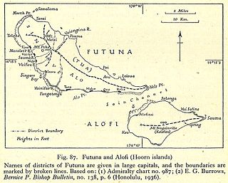
Futuna is the largest island in Hoorn Islands or Îles Horne, located in the Pacific Ocean, part of the French overseas collectivity of Wallis and Futuna. The island occupies an area of 80 km2 (30 sq mi) and as of 2018 it has a population of 10,912.

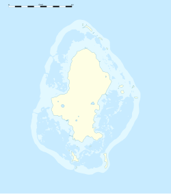
Wallis is a Polynesian atoll/island in the Pacific Ocean belonging to the French overseas collectivity of Wallis and Futuna. It lies north of Tonga, northeast of Fiji, east-northeast of the Hoorn Islands, east of Fiji's Rotuma, southeast of Tuvalu, southwest of Tokelau and west of Samoa. Its area is almost 100 km2 (39 sq mi) with 8,333 people. Its capital is Mata Utu. Roman Catholicism is the predominant religion. Its highest point is Mount Lulu Fakahega. Wallis is of volcanic origin with fertile soil and some remaining lakes. Rainfall is plentiful.

Mata Utu is the capital city of Wallis and Futuna, an overseas collectivity of France. It is located on the island of Uvéa (ʻUvea), in the district of Hahake, of which it is also the capital. It is one of two ports in Wallis and Futuna, the other being at Leava on Futuna. Hihifo Airport, the main airport serving the island and city, is 5.6 kilometres (3.5 mi) to the northwest. Its population was 1,029 in 2018, up from 815 in 1998.
Wallisian, or ʻUvean, is the Polynesian language spoken on Wallis Island. The language is also known as East Uvean to distinguish it from the related West Uvean language spoken on the outlier island of Ouvéa near New Caledonia. The latter island was colonised from Wallis Island in the 18th century.

Hakake is one of the 5 districts of Wallis and Futuna, located in Wallis Island, in the Pacific Ocean. It is part of the Chiefdom of Uvea.

The Wallis and Futuna national football team is the national soccer team of Wallis and Futuna. Wallis and Futuna is not a member of FIFA and, therefore, is not eligible to enter either the FIFA World Cup or the OFC Nations Cup, and due to the low investment in sport on the part of the country, it has been many years since it played an international match.

Lake Lalolalo is a volcanic crater lake surrounded by jungle to the southwest of the island of Wallis (Uvea) in the Pacific Ocean. The largest lake on the island, it lies off Route 1 between the coastal village of Mala'etoli and Ahoa. A small lake, Lake Lano, lies just to the northwest.

The University of New Caledonia UNC is a French university which is part of the Academy of New Caledonia located in Nouméa and Koné.
The following outline is provided as an overview of and topical guide to Wallis and Futuna:

Rugby union in Wallis and Futuna is a popular sport within the French overseas territory.
The sport of football in the overseas collectivity of Wallis and Futuna is governed by the Fédération de Ligue de Football de Wallis et Futuna. The association administers the Wallis and Futuna national football team as well as the Wallis Première Division and the Futuna Première Division. No women's football is known of, though it is possible that the sport is not segregated by gender for youth football.
Lake Alofivai is a lake on the northeastern side of Wallis (Uvea) in the Pacific. It is located off Route 1 (RT1) adjacent to the village of Alofivai. The lake is reportedly "often dry, and the bottom of the crater then affords pasture for the cows of the nearby mission schools." However, during wetter periods, the lake is populated with frogs.

Severe Tropical Cyclone Fran was the third tropical cyclone within four weeks to impact Vanuatu in 1992. Fran formed on 4 March and then gradually intensified, with winds reaching gale-force on 5 March, and hurricane-force a few days later. Few days later, Cyclone Fran reached severe tropical cyclone status near Vanuatu, and also became a powerful Category 5-equivalent on the Saffir–Simpson Hurricane Scale. The storm weakened somewhat due to land interaction, but briefly re-intensified after moving away from land. Fran gradually weakened over the next several days over less favorable conditions. Meanwhile, the storm passed north of New Caledonia. Eventually, as a Category 2 system on the Australian scale, Fran made landfall on Queensland on 16 March. Afterwards, Cyclone Fran turned towards the southeast and eventually headed back out to sea, eventually dissipating the next day. On Efate, over 130 houses lost roofs. Along Queensland, two rivers sustained major flooding, but no deaths were attributed to this cyclone. Total damage from the system was AU$8–10 million. Moderate damage was also reported in Fiji. In New Caledonia, the storm brought flooding and landslides.
Severe Tropical Cyclone Ron was the strongest tropical cyclone on record to impact Tonga. The system was first noted as a tropical depression, to the northeast of Samoa on January 1, 1998. Over the next day the system gradually developed further and was named Ron as it developed into a Category 1 tropical cyclone on the Australian tropical cyclone intensity scale during the next day. The system subsequently continued to move south-westwards and became a Category 3 severe tropical cyclone, as it passed near Swains Island during January 3.
Severe Tropical Cyclone Evan was considered to be the worst tropical cyclone to affect the island nation of Samoa since Cyclone Val in 1991 and was the strongest storm to impact the main South Pacific islands until Winston in 2016. The system was first noted on December 9, 2012, as a weak tropical depression about 700 km (435 mi) to the northeast of Suva, Fiji. Over the next couple of days, the depression gradually developed further before it was named Evan on December 12, as it had fully developed into a tropical cyclone. During that day the system moved toward the Samoan Islands and gradually intensified, before the system slowed and severely affected the Samoan Islands during the next day with wind gusts of up to 210 km/h (130 mph).
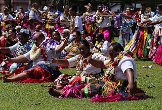
Wallis and Futuna, an overseas territory of France in Oceania, has a rich Polynesian culture that is very similar to the cultures of its neighbouring nations Samoa and Tonga. The Wallisian and Futunan cultures share very similar components in language, dance, cuisine and modes of celebration.

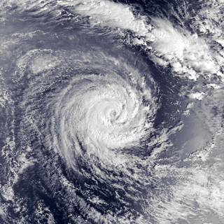
Severe Tropical Cyclone Hina in March 1997 was the worst tropical cyclone to affect the South Pacific island nation of Tonga since Cyclone Isaac in 1982. The system was first noted within the monsoon trough on March 11, 1997, as a weak shallow depression within the vicinity of Rotuma. Over the next two days, the depression remained near Rotuma with no preferred movement, as it started to develop further within favorable conditions for further development. The system was subsequently named Hina on March 15, after it had started to move eastwards and had passed to the southeast of Niulakita, Tuvalu. During that day the system moved south-eastwards and impacted Wallis and Futuna, before it passed over Tonga's southern islands of Tongatapu and 'Eua during March 16. After impacting Tonga the system moved rapidly towards the south-southeast and weakened below tropical cyclone intensity, before it was last noted on March 21 about 1,500 km (930 mi) to the south of the Pitcairn Islands. During the system's post-analysis, it was determined that the warning centers had underestimated Hina's intensity as it passed over Tonga, after damage in the island nation had been greater than expected.
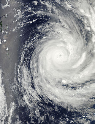
Severe Tropical Cyclone Raja was a tropical cyclone that holds the 24-hour rainfall record of 674.9 mm (26.57 in) for the French Overseas Territory of Wallis and Futuna. The system was first noted by the Fiji Meteorological Service (FMS) as a weak tropical disturbance northeast of Tokelau in mid-December 1986. The system developed further as it moved southwest over the next few days, and it was classified as Tropical Cyclone Raja on 23 December. The newly named system slowed and unexpectedly recurved southeast towards the French territory of Wallis and Futuna on 24 December. Over the next two days, Raja interacted with what would become Severe Cyclone Sally and executed a tight loop, passing within 55 km (35 mi) of Futuna. The system peaked as a Category 3 severe tropical cyclone on 28 December, with estimated 10-minute sustained winds of 90 mph (150 km/h). The storm turned southwest the next day and threatened Fiji, where it passed within 20 km (10 mi) of Vanua Levu and near several smaller islands in the Lau group during the following day. Raja gradually weakened over the next few days as it moved south of Fiji; it was last noted on 5 January 1987 after it filled up over the north Tasman Sea.
Soakimi Gatafahefa, also known as simply Soakimi Gata, a Polynesian transliteration of Joachim Gata, was the first Roman Catholic priest from Polynesia. He worked in several Oceanic countries including Tonga, Samoa, Fiji, Wallis and Futuna, and later Australia and New Zealand.