Altamira (Caracas)

Last updated
Aereal view of the Plaza Francia and its surroundings, which compose the Altamira zone of Caracas. Vista aerea de la Plaza Altamira de Caracas.jpg
Aereal view of the Plaza Francia and its surroundings, which compose the Altamira zone of Caracas.

Altamira is a neighborhood located in the Chacao municipality of Caracas, Venezuela. It has its own Metro Station, many hotels and restaurants, and it is an important business and residential center of the city. It is also an important tourist destination and cultural center in Caracas. The Francisco de Miranda avenue (a major avenue in Caracas) and the Distibuidor Altamira (a congested highway exit) are both located in Altamira. This neighborhood borders El Ávila National Park to the north, La Castellana neighborhood to the west, Los Palos Grandes to the east, and Bello Campo neighborhood to the south.

Caracas Metro rapid transit system in Caracas, Venezuela

The Caracas Metro is a mass rapid transit system serving Caracas, Venezuela. It was constructed and is operated by Compañía Anónima Metro de Caracas, a government-owned company that was founded in 1977 by José González-Lander who headed the project for more than thirty years since the early planning stages in the 1960s. Its motto is "Somos parte de tu vida". In 1978 MTA - New York City Transit's R46 #1216 was shipped from the Pullman Standard's plant as a sample of rolling stock to be used for this new Metro system that was under construction at the time.

Francisco de Miranda Venezuelan revolutionary

Sebastián Francisco de Miranda y Rodríguez de Espinoza, commonly known as Francisco de Miranda, was a Venezuelan military leader and revolutionary. Although his own plans for the independence of the Spanish American colonies failed, he is regarded as a forerunner of Simón Bolívar, who during the Spanish American wars of independence successfully liberated much of South America. He was known as "The First Universal Venezuelan" and "The Great Universal American". In the National Archive of Venezuela can be found the statute of the blood purity of the father of Francisco de Miranda.

Interchange (road) road junction, typically using grade separation

In the field of road transport, an interchange is a road junction that uses grade separation, and typically one or more ramps, to permit traffic on at least one highway to pass through the junction without interruption from other crossing traffic streams. It differs from a standard intersection, where roads cross at grade. Interchanges are almost always used when at least one road is a controlled-access highway or a limited-access divided highway (expressway), though they are sometimes used at junctions between surface streets.

Contents

History

Plaza Francia Plaza Francia.jpg
Plaza Francia
View from Altamira neighborhood ChacaoAltamiraView2004-8.jpg
View from Altamira neighborhood

Altamira was created on June 30, 1577, by Juan Andres Varela. This neighborhood is currently home to Plaza Francia (though it is commonly called Plaza Altamira), a well-known landmark which includes an obelisk and a fountain. This square and most of Altamira was built by Luis Roche, who owned most of the area in 1943. In 1944, Luis Roche ordered -with permission of the government- the construction of many avenues and the square. Roche wanted the square's obelisk to be "higher than the Cathedral of Caracas". [ citation needed ] The square was completed by Martin Hermanos co on August 11, 1945, and was originally called Plaza Altamira. On January 17, 1967, the Venezuelan and French governments agreed to rename Plaza Altamira to Plaza Francia (France Square in Spanish). The French government built a Plaza Venezuela in their country in 1975.[ citation needed ]

Plaza Francia (Caracas) square in Caracas, Venezuela

Plaza Francia, also known as "Plaza Altamira", is a public space located in Altamira, east Caracas. It was built at the beginning of the 1940s and opened in August 11, 1945 with the original name of "Plaza Altamira". Is name was later changed due to an agreement between the cities of Caracas and Paris to have a Venezuela Square in Paris and a France Square in Caracas. This square was designed by town planner Luis Roche within the project of "Altamira neighborhood", a wealthy district of Chacao municipality in Miranda States.

An obelisk is a tall, four-sided, narrow tapering monument which ends in a pyramid-like shape or pyramidion at the top. These were originally called tekhenu by their builders, the Ancient Egyptians. The Greeks who saw them used the Greek term 'obeliskos' to describe them, and this word passed into Latin and ultimately English. Ancient obelisks are monolithic; that is, they consist of a single stone. Most modern obelisks are made of several stones; some, like the Washington Monument, are buildings.

Luis Roche was an important Venezuelan urbanist and was the Venezuelan ambassador to Argentina. He was also an amateur film director.

In 1948, Luis Roche began exploring the possibility of building a tunnel between Altamira and the Caribbean Sea. He contacted the people who were in charge of the construction of the Hudson River Tunnels, in New York City. This project was scrapped due to its high cost as it required three tunnels, two of them used exclusively for ventilation. If built, the tunnel would have been about eight kilometers long. Luis Roche was later assigned Venezuelan Ambassador to Argentina.

Caribbean Sea A sea of the Atlantic Ocean bounded by North, Central, and South America

The Caribbean Sea is a sea of the Atlantic Ocean in the tropics of the Western Hemisphere. It is bounded by Mexico and Central America to the west and south west, to the north by the Greater Antilles starting with Cuba, to the east by the Lesser Antilles, and to the south by the north coast of South America.

Hudson River river in New York State, draining into the Atlantic at New York City

The Hudson River is a 315-mile (507 km) river that flows from north to south primarily through eastern New York in the United States. The river originates in the Adirondack Mountains of Upstate New York, flows southward through the Hudson Valley to the Upper New York Bay between New York City and Jersey City. It eventually drains into the Atlantic Ocean at New York Harbor. The river serves as a political boundary between the states of New Jersey and New York at its southern end. Further north, it marks local boundaries between several New York counties. The lower half of the river is a tidal estuary, deeper than the body of water into which it flows, occupying the Hudson Fjord, an inlet which formed during the most recent period of North American glaciation, estimated at 26,000 to 13,300 years ago. Tidal waters influence the Hudson's flow from as far north as the city of Troy.

New York City Largest city in the United States

The City of New York, usually called either New York City (NYC) or simply New York (NY), is the most populous city in the United States and thus also in the state of New York. With an estimated 2017 population of 8,622,698 distributed over a land area of about 302.6 square miles (784 km2), New York is also the most densely populated major city in the United States. Located at the southern tip of the state of New York, the city is the center of the New York metropolitan area, the largest metropolitan area in the world by urban landmass and one of the world's most populous megacities, with an estimated 20,320,876 people in its 2017 Metropolitan Statistical Area and 23,876,155 residents in its Combined Statistical Area. A global power city, New York City has been described as the cultural, financial, and media capital of the world, and exerts a significant impact upon commerce, entertainment, research, technology, education, politics, tourism, art, fashion, and sports. The city's fast pace has inspired the term New York minute. Home to the headquarters of the United Nations, New York is an important center for international diplomacy.

Today, Altamira has its own Metro Station, many hotels and restaurants, and is an important business center in Caracas. Avenida Francisco de Miranda (a major avenue in Caracas) and the Distribuidor Altamira (a congested highway exit) are both located in Altamira.

Altamira was the scene of a mass shooting on December 6, 2002. João de Gouveia murdered three citizens and injured 19 participating in a demonstration in Plaza Altamira against Venezuelan president Hugo Chávez. [1] The shooting occurred during the 2002-2003 general strike. On August 16, 2004, Plaza Francia was the scene of another incident. A group of opposition activists, protesting what they considered to be fraudulent electoral results of the Presidential Recall Referendum, were met with a hail of bullets from a group of Pro-Government supporters. [2] One person was killed and nine wounded. The gunmen were clearly identified by photographs taken by AP and Reuters photographers. Authorities detained and sentenced Jhon Carlos Jiménez Esalas (32), Henry José Parra Linero (29) and Pedro Celestino Ramos Ponche (56) [2] [3]

Hugo Chávez 48th President of Venezuela

Hugo Rafael Chávez Frías was a Venezuelan politician who was President of Venezuela from 1999 to 2013. Chávez was also leader of the Fifth Republic Movement political party from its foundation in 1997 until 2007, when it merged with several other parties to form the United Socialist Party of Venezuela (PSUV), which he led until 2012.

Education

The British School, Caracas is in Altamira. [4]

A branch of the worldwide Tomchei Tmimim [5] . The hub of the bajurim.

See also

Related Research Articles

Capital District (Venezuela) Place

The Capital District is Venezuela's federal district. It has an area of 433 km2 and there is only one administrative division (municipio), Libertador, which contains about half of Caracas, the Venezuelan capital city, which is also the seat of the three branches of the federal government of Venezuela.

Chacao Municipality Municipality in Miranda, Venezuela

Chacao is one of the five political and administrative subdivisions of the city of Caracas, Venezuela. The other four are Baruta, El Hatillo, Libertador and Sucre. This legal entity is known as the Caracas Metropolitan District. Chacao is also one of the 21 municipalities that make up the State of Miranda, Venezuela.

Municipalities of Venezuela

Municipalities of Venezuela are subdivisions of the States of Venezuela. There are 335 municipalities dividing the 23 states and Capital District.

El Hatillo Municipality Municipality in Miranda, Venezuela

El Hatillo Municipality is an administrative division of the State of Miranda, Venezuela; along with Baruta, Chacao, Libertador and Sucre, it is one of the five municipalities of Caracas, the capital of Venezuela. It is located in the southeastern area of Caracas, and in the northwestern part of the State of Miranda.

Libertador Bolivarian Municipality Municipality in Capital District, Venezuela

The Libertador Bolivarian Municipality is the only administrative division of the Capital District and along with the municipalities of Baruta, Chacao, El Hatillo and Sucre forms the Metropolitan District of Caracas. It is landlocked by Vargas State and also borders Miranda State on the east and south. The municipality is one of a number in Venezuela named "Libertador Municipality", in honour of Venezuelan independence hero Simón Bolívar.

Las Mercedes, Caracas

Las Mercedes is the largest district for shopping and leisure in Latin America. It is located at the Baruta Municipality, Miranda (state), Caracas.

The Ministry of Aquatic and Air Transport is a ministry of the Government of Venezuela. Its head office is on the 12th floor of the Torre Pequiven in Chacao Municipality, Caracas.

El Rosal, Caracas Neighborhood of Caracas, Venezuela

El Rosal is a neighbourhood of Caracas, Venezuela, in the Chacao municipality. It is located at East Caracas, near the geographic center of Caracas and is one of its financial centres.

La Castellana, Caracas Neighborhood in Caracas, Venezuela

La Castellana is a district in Caracas, Venezuela, located in the northeast part of the city, La Castellana is bordered on the south by Chacao, on the east by Altamira (Caracas) neighbourhood, on the west by Caracas Country Club and Campo Alegre neighbourhood and on the north by El Ávila National Park.

Campo Alegre, Caracas

Campo Alegre is a residential neighborhood located in the Chacao municipality of Caracas, Venezuela. This district holds the hotel Embassy Suites by Hilton , and the most exclusive party room of the city, the "Quinta Esmeralda", meeting point of the Venezuelan upper-class families.

Los Palos Grandes

Los Palos Grandes is a residential, tourist and financial district located in the Chacao Municipality in east Caracas, served by the Caracas Metro through the Miranda station of line 1.

Timeline of the 2014 Venezuelan protests

The 2014 Venezuelan protests began in February 2014 when hundreds of thousands of Venezuelans protested due to high levels of criminal violence, inflation, and chronic scarcity of basic goods because of policies created the Venezuelan government. The protests have lasted for several months and events are listed below according to the month they had happened.

Timeline of the 2015 Venezuelan protests

The 2015 Venezuelan protests began in the first days of January primarily due to shortages in Venezuela, with the first massive demonstration occurring on 23 January. The series of protests originally began in February 2014 when hundreds of thousands of Venezuelans protested due to high levels of criminal violence, inflation, and chronic scarcity of basic goods because of policies created the Venezuelan government. As of January 2015, over 50 people had been arrested for protesting. The protests are listed below according to the month they had happened.

East Caracas Municipalities of East Caracas in Miranda, Venezuela

East Caracas generally refers to the eastern portions of Caracas, and may refer specifically to the municipalities from the Metropolitan District of Caracas located in Miranda State: Chacao, Baruta, Sucre, and El Hatillo. It concentrates the 34.8% population of the Metropolitan District of Caracas, and the 21.7% population of the Greater Caracas Area. A very small portion of East Caracas is located in El Recreo Parish of Libertador Municipality, however. That area is considered the East-Center portion of Caracas. Caracas Country Club, the richest neighborhood of the city, is located between El Recreo and Chacao districts.

Sabana Grande, Caracas Caracas

The Sabana Grande district is divided into several middle class neighborhoods located in the Parroquia El Recreo of the Libertador Municipality, in the geographical center of the Metropolitan District of Caracas and owes its name to the old town of Sabana Grande. The Twin Towers of El Recreo Shopping Mall occupy the position number 5 and number 6 of the tallest skyscrapers in Caracas, the capital of Venezuela. The most important neighborhoods of the district are: Sabana Grande, Bello Monte, San Antonio de Sabana Grande, Las Delicias de Sabana Grande and Los Caobos. Sabana Grande is an important commercial, financial, residential and cultural area within the city in the Capital District, on the east side of the central Plaza Venezuela and Los Caobos. The commercial and financial district Sabana Grande is the main commercial corridor of the city and it is estimated that more than 500 thousand people visit it daily. Parroquia El Recreo, specifically Sabana Grande, is the most commercial area of the Libertador Municipality and produces more than half of its tax revenue. For several years, Parroquia El Recreo has wanted to be an independent municipality. Sabana Grande is a district with a very rich history and was the cradle of Venezuelan democracy, since the Puntofijo Pact was signed there. Before suffering a cerebral infarction in 2009, Argentine musician Gustavo Cerati had gone out to party at the Bohemian club Moulin Rouge, located on Francisco Solano López Avenue in Sabana Grande.

Boulevard of Sabana Grande national historical monument of Venezuela in Caracas

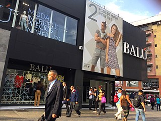
The Boulevard of Sabana Grande is an important leisure and shopping area located in eastern Caracas in the geographic center of the Metropolitan District of Caracas. It is a pedestrian-only, tree-shaded public space. In 2011, the boulevard of Sabana Grande went through a rehabilitation process, thanks to PDVSA La Estancia. A commercial and financial district, Sabana Grande is the commercial corridor, and a tourist district of Caracas and is visited by an estimated 500 thousand people or more daily. Since the construction of the boulevard, the Sabana Grande district has become the main meeting place of Caracas.. Today, Sabana Grande has stores such as Balú H&M, Apolo Shoes, Brands Shop (Estivaneli-Alcott) Planeta Sports (Levi's), Angely, AISHOP, Mango and others. Many important public works of art are displayed along the boulevard and it is considered an open air museum. The boulevard of Sabana Grande is home to the most important ornithological collection in Latin America, the William Phelps Ornithological Collection. It is the space preferred by the LGBT community and urban tribes. The boulevard of Sabana Grande replaced Abraham Lincoln Avenue. Until the beginning of the 20th century, it was called Calle Real because it was the town's main road. Sabana Grande was the residence of Jenie Soep Bamberger, one of the most important madams in 20th century Latin America. The first gay march in Venezuela took place in the Sabana Grande district at midnight on June 23, 1997. City Market Shopping Center, known as the technology center of Caracas, is also located here. In 2013, Revista Distorxión displayed a guitar autographed by Good Charlotte in the City Market Shopping Mall. The boulevard of Sabana Grande is also considered the main bohemian district of Caracas.

El Cafetal Place in Miranda, Venezuela

El Cafetal is a neighborhood located in the Baruta Municipality of Caracas, Venezuela.

References

  1. "Condena por muertos en protesta" (in Spanish). BBC. April 15, 2003. Retrieved 2007-07-09.
  2. 1 2 http://archivo.eluniversal.com/2004/09/05/pol_art_05154A.shtml
  3. (in Spanish) "Sentence". Tribunal Décimo Noveno de Juicio, República Bolivariana de Venezuela. Archived from the original on 21 August 2011. Retrieved 5 August 2010.
  4. "Contact Us Archived 2015-03-02 at the Wayback Machine .." The British School, Caracas. Retrieved on March 16, 2015. "Street Address: Transversal 9 Este Av. Luis Roche Urbanización Altamira Caracas, VENEZUELA"
  5. http://www.jabadve.com

Coordinates: 10°29′N66°50′W / 10.483°N 66.833°W / 10.483; -66.833