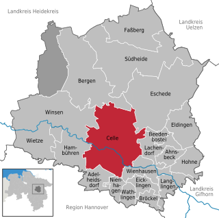
Celle is a town and capital of the district of Celle, in Lower Saxony, Germany. The town is situated on the banks of the river Aller, a tributary of the Weser and has a population of about 71,000. Celle is the southern gateway to the Lüneburg Heath, has a castle built in the Renaissance and Baroque style and a picturesque old town centre with over 400 timber-framed houses, making Celle one of the most remarkable members of the German Timber-Frame Road. From 1378 to 1705, Celle was the official residence of the Lüneburg branch of the dukes of Brunswick-Lüneburg who had been banished from their original ducal seat by its townsfolk.

The Aller is a 215-kilometre-long (134 mi) river in the states of Saxony-Anhalt and Lower Saxony in Germany. It is a right-hand, and hence eastern, tributary of the Weser and is also its largest tributary. Its last 117 kilometres (73 mi) form the Lower Aller federal waterway (Bundeswasserstraße). The Aller was extensively straightened, widened and, in places, dyked, during the 1960s to provide flood control of the river. In a 20-kilometre-long (12 mi) section near Gifhorn, the river meanders in its natural river bed.

Hildesheim[ˈhɪldəsˌhaɪ̯m](listen) is a city in Lower Saxony, Germany with 101,693 inhabitants. It is in the district of Hildesheim, about 30 km (19 mi) southeast of Hanover on the banks of the Innerste River, a small tributary of the Leine River.

Bernburg (Saale) is a town in Saxony-Anhalt, Germany, capital of the Salzlandkreis district. The former residence of the Anhalt-Bernburg princes is known for its Renaissance castle.
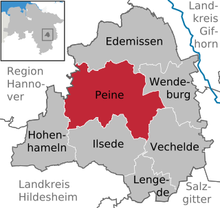
Peine is a town in Lower Saxony, Germany, capital of the district Peine. It is situated on the river Fuhse and the Mittellandkanal, approximately 25 km west of Braunschweig, and 40 km east of Hanover.
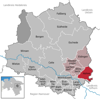
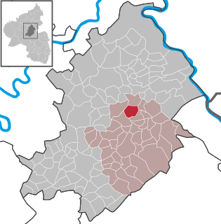
Hohne is a municipality in the state of Lower Saxony in Germany, east of the county town of Celle. It includes the three former parishes of Hohne, Helmerkamp and Spechtshorn. It should not be confused with the British Army camp of Hohne near Belsen about 30 km to the northwest.

Amelinghausen is a municipality in the district of Lüneburg in Lower Saxony, Germany. It is also the seat of the collective municipality (Samtgemeinde) of Amelinghausen.
The Principality of Lüneburg was a territorial division of the Duchy of Brunswick-Lüneburg within the Holy Roman Empire, immediately subordinate to the emperor. It existed from 1269 until 1705 and its territory lay within the modern-day state of Lower Saxony in Germany. The principality was named after its first capital, Lüneburg, which was ruled jointly by all Brunswick-Lüneburg lines until 1637. From 1378, the seat of the principality was in Celle. It lost its independence in 1705 when it was annexed by the Electorate of Brunswick-Lüneburg, but retained its vote in the Reichstag as Brunswick-Celle.
Kastellaun is a town in the Rhein-Hunsrück-Kreis (district) in Rhineland-Palatinate, Germany. It is the seat of the like-named Verbandsgemeinde, a kind of collective municipality.

Bürgstadt is a market community in the Miltenberg district in the Regierungsbezirk of Lower Franconia (Unterfranken) in Bavaria, Germany and the seat of the Verwaltungsgemeinschaft of Erftal. Bürgstadt is a winegrowing community in the wine region of Franken. It has a population of around 4,300.

Beilstein is an Ortsgemeinde – a municipality belonging to a Verbandsgemeinde, a kind of collective municipality – in the Cochem-Zell district in Rhineland-Palatinate, Germany. It belongs to the Verbandsgemeinde of Cochem, whose seat is in the like-named town.
Horn is an Ortsgemeinde – a municipality belonging to a Verbandsgemeinde, a kind of collective municipality – in the Rhein-Hunsrück-Kreis (district) in Rhineland-Palatinate, Germany. It belongs to the Verbandsgemeinde Simmern-Rheinböllen, whose seat is in Simmern.

Celle Castle or, less commonly, Celle Palace, in the German town of Celle in Lower Saxony, was one of the residences of the House of Brunswick-Lüneburg. This quadrangular building is the largest castle in the southern Lüneburg Heath region.
The circular rampart of Burg is a defensive work from the Early Middle Ages period located near the German town of Celle in Lower Saxony. The site, dating roughly to the 10th century and located in an inaccessible area of marsh by the River Fuhse, probably acted as a refuge for the local population. Today this 3-metre-high (9.8 ft) circular embankment belongs to one of the most important Early Middle Age historical monuments in Celle.

Westercelle is a suburb of the district town of Celle in Lower Saxony, Germany, that lies 3 kilometres south of the town centre on the river Fuhse.
Neuenhäusen is a suburb of the town of Celle in Lower Saxony, Germany, and lies south of the Altstadt in its centre. A particular feature of this suburb is that it is where most of the many authorities and public institutions, that have their headquarters in Celle, are located.

The Bundesstraße 214 is a federal road that runs from Lingen to Brunswick in North Germany.

Gifhorn Castle is a castle in Gifhorn, Germany, built between 1525 and 1581 in the Weser Renaissance style. The castle was fortified until 1790 with moats, ramparts and bastions and was never captured. In the 16th century it was the Residenz of the Duchy of Gifhorn under Duke Francis of Brunswick-Lüneburg for just 10 years.

Calenberg Castle was a medieval lowland castle in central Germany, near Schulenburg in the borough of Pattensen, 13 km west of the city of Hildesheim. It was built as a water castle in 1292 by the Welf duke, Otto the Strict, in der Leine river meadows between 2 branches of the Leine river on the southern part of the chalk marl hill of the Calenberg. At the start of the 16th century it was converted into a fort (Feste). In the 15th century, Fort Calenberg gave its name to the Welf Principality of Calenberg. Following the Thirty Years' War it lost its military importance and was slighted. Today it is a ruin with underground vaults that are surrounded by high ramparts.

The Old Castle was a former Elector-owned, substantial water castle in the German city of Koblenz, incepted in the 13th century. It is today reduced to the later Burghaus ; which houses the city archives. It sits on tall foundations and has a tall, black slate roof with further floors in the attic and two small cupolas. The lowland castle abutted the remaining building in the old town quarter. The castle house stands tall, next to the Moselle's right-bank towpath downstream of the strategic Baldwin Bridge built in 1342. The bridge, much-repaired, remains intact.


