
Celle is a town and capital of the district of Celle in Lower Saxony, in north-central Germany. The town is situated on the banks of the river Aller, a tributary of the Weser, and has a population of about 71,000. Celle is the southern gateway to the Lüneburg Heath, has a castle built in the Renaissance and Baroque styles and a picturesque old town centre with more than 400 timber-framed houses, making Celle one of the most remarkable members of the German Timber-Frame Road. From 1378 to 1705 Celle was the official residence of the Lüneburg branch of the dukes of Brunswick-Lüneburg, who had been banished from their original ducal seat by its townsfolk.

The canton of Schaffhausen, also canton of Schaffhouse, is the northernmost canton of Switzerland. The principal city and capital of the canton is Schaffhausen. The canton's territory is divided into three non-contiguous segments, where German territory reaches the Rhine. The large central part, which includes the capital, in turn separates the German exclave of Büsingen am Hochrhein from the rest of Germany.
Soltau is a mid-sized town in the Lüneburg Heath in the district of Heidekreis, in Lower Saxony, Germany. It has around 22,000 inhabitants. The city is centrally located in the Lüneburg Heath and is known nationwide especially for its tourist attractions like the Heide-Park and the Soltau-Therme.

Hannover Hauptbahnhof is the main railway station for the city of Hanover in Lower Saxony, Germany. The railway junction is one of the 21 stations listed as a railway Category 1 station by DB Station&Service. It is also the most important public transport hub of the region of Hanover and it is served regional and S-Bahn services. The station has six platforms with twelve platform tracks, and two through tracks without platforms. Every day it is used by 250,000 passengers and 622 trains stop at the platforms. About 2,000 people work here.

Burgdorf is a town in the Hanover Region, in Lower Saxony, Germany. It is situated approximately 22 km northeast of Hanover. Until 1974, Burgdorf was the capital of the Burgdorf district. The town and its surrounding areas are known for the tradition of growing white Asparagus and for breeding Hanoverian horses. Burgdorf hosts a monthly horse market from April to September every year.
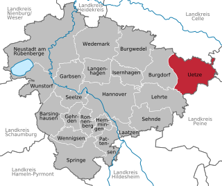
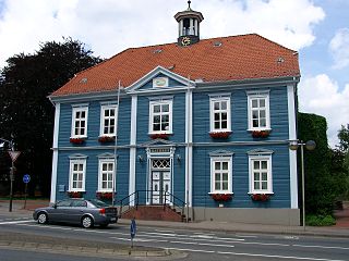
Uetze [ˈʏt͡sə] is a municipality in the district of Hanover, in Lower Saxony, Germany. It is situated on the river Fuhse, approximately 35 km (22 mi) east of Hanover.

Schlieren is a municipality in the district of Dietikon in the canton of Zürich in Switzerland.

Bremerhaven is a city on the east bank of the Weser estuary in northern Germany. It forms an exclave of the city-state of Bremen. The River Geeste flows through the city before emptying into the Weser.
The Osthannoversche Eisenbahnen AG (OHE) is a Celle based transportation company with railway network in North-eastern Lower Saxony around the Lüneburg Heath area of over 250 km.
Altencelle is part of the borough of Celle in Lower Saxony and lies southeast of the town centre, west of the River Aller and east of the Fuhse. It is linked to Celle by the B 214 federal road and state highway K 74.
Garßen is a Lower Saxon village in the southern part of the Lüneburg Heath and, since 1973, part of the borough of Celle in Germany. It lies on the northeastern side of the town.
Neuenhäusen is a suburb of the town of Celle in Lower Saxony, Germany, and lies south of the Altstadt in its centre. A particular feature of this suburb is that it is where most of the many authorities and public institutions, that have their headquarters in Celle, are located.

Wietzenbruch is a suburb in the southwest of the Lower Saxon town of Celle, which was named after the fen wood (Bruchwald) bisected by the river Wietze. Originally, the centre of Wietzenbruch was a small estate farm.

The Bundesstraße 214 is a federal road that runs from Lingen to Brunswick in North Germany.

Wietze is a river of Lower Saxony, Germany, a tributary of the Aller. Its total length including its source river Edder is 41.0 km (25.5 mi).
The Celle-Soltau, Celle-Munster Light Railway was until 1908 a publicly owned company run by the district of Celle in North Germany and was originally named the Garßen–Bergen Light Railway.
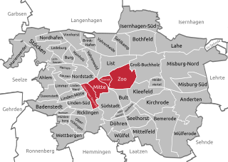
Mitte is the first borough of Hanover, the state capital of Lower Saxony. As of 2020, it has 36,645 inhabitants and consists of the quarters Mitte, Calenberger Neustadt, Oststadt and Zoo. The district mayor is Cornelia Kupsch (CDU).

The Deister Gate is a 550-metre-wide gap between the Deister and Kleiner Deister hill ridges in Springe in Hanover Region, Lower Saxony, Germany. The height of the pass varies between 130 m above NN to 120 m above NN. The River Haller rises in the Deister Gate. Several transport and supply routes run through the Deister Gate.

Langenhagen Pferdemarkt station (Langenhagen (Han) until 27 May 2000) is a station in the town of Langenhagen, which lies north of Hanover, the capital of the German state of Lower Saxony. At present it is served by lines S4 and S5 of the Hanover S-Bahn. It was opened as Langenhagen station in 1890 and was the only station in Langenhagen in the first half of the 20th century. Three extra stations have been built since because of the growth of Langenhagen and the development of Hannover Airport. Since regional and long-distance services now only stop in the neighbouring Langenhagen Mitte station, Pferdemarkt station is now only served by S-Bahn services.

Celle station is a railway station in the municipality of Celle, located in the Celle district in Lower Saxony, Germany.


