Alvarado, Indiana

Last updated

Alvarado, Indiana
Alvarado IN USA 1.jpg
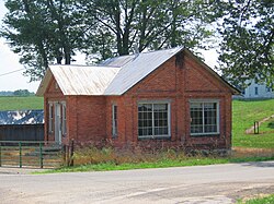
An old brick house in Alvarado
USA Indiana location map.svg
Red pog.svg
Alvarado
Usa edcp location map.svg
Red pog.svg
Alvarado
Coordinates: 41°34′36″N84°50′16″W / 41.57667°N 84.83778°W / 41.57667; -84.83778
Country United States
State Indiana
County Steuben
Township Richland
Elevation
[1]
958 ft (292 m)
Time zone UTC-5 (Eastern (EST))
  Summer (DST) UTC-4 (EDT)
ZIP code
46742
Area code 260
GNIS feature ID430126 [1]

Alvarado is an unincorporated community in Richland Township, Steuben County, in the U.S. state of Indiana. [1]

History

A post office was established at Alvarado in 1855, and remained in operation until 1904. [2] An old variant name of the community was called Richland Center. [3]

In 1849, the Alvarado United Methodist Church was built, and is still in service today. [4]

References

  1. 1 2 3 U.S. Geological Survey Geographic Names Information System: Alvarado, Indiana
  2. "Steuben County". Jim Forte Postal History. Retrieved October 3, 2016.
  3. "USGS detail on Alvarado - Variant Citation" . Retrieved October 3, 2016.
  4. "Alvarado United Methodist Church". Alvarado United Methodist Church. Retrieved June 6, 2018.