
The Nile is a major north-flowing river in northeastern Africa. It flows into the Mediterranean Sea. The Nile is the longest river in Africa. It has historically been considered the longest river in the world, though this has been contested by research suggesting that the Amazon River is slightly longer. Of the world's major rivers, the Nile is one of the smallest, as measured by annual flow in cubic metres of water. About 6,650 km (4,130 mi) long, its drainage basin covers eleven countries: the Democratic Republic of the Congo, Tanzania, Burundi, Rwanda, Uganda, Kenya, Ethiopia, Eritrea, South Sudan, Sudan, and Egypt. In particular, the Nile is the primary water source of Egypt, Sudan and South Sudan. The Nile is an important economic driver supporting agriculture and fishing.
The Gambela Region (also spelled Gambella (Catching the male Leopard in Anywaa language); Amharic: ጋምቤላ), officially the Gambela Peoples' Region, is a regional state in western Ethiopia, bordering South Sudan. Previously known as Region 12, its capital is Gambela located in Anywaa zone. The Region is situated between the Baro and Akobo Rivers, with its western part including the Openo River. Covering an area of approximately 29,783 square kilometers, Gambela is one of Ethiopia's smaller regions and one of its least populous, with 525,000 inhabitants. It is home to a diverse population, including the Anuak the indigenous, Nuer, and other indigenous groups called Majang Komo and Opo. The region's economy is largely based on agriculture, with significant contributions from fishing and cross-border trade. The landscape is characterized by lowland plains, wetlands, and a tropical climate, making it distinct from the highland areas that dominate much of Ethiopia.

The Awash River is a major river of Ethiopia. Its course is entirely contained within the boundaries of Ethiopia and empties into a chain of interconnected lakes that begin with Lake Gargori and end with Lake Abbe on the border with Djibouti, some 100 kilometres from the head of the Gulf of Tadjoura. The Awash River is the principal stream of an endorheic drainage basin covering parts of the Amhara, Oromia and Somali Regions, as well as the southern half of the Afar Region. The Awash River basin, spanning 23 administrative zones, covers 10% of Ethiopia's area.

Gambela, also spelled Gambella, is a city and separate woreda in Ethiopia and the capital of the Gambela Region. Located in Anyuak Zone, at the confluence of the Baro River and its tributary the Jajjabe, the city has a latitude and longitude of 8°15′N34°35′E and an elevation of 526 meters. It is surrounded by Gambella Zuria.

The Anyuak, also known as Anyuaa and Anywaa, are a Luo Nilotic ethnic group inhabiting parts of East Africa. The Anuak belong to the larger Luo family group. Their language is referred to as Dha-Anywaa. They primarily reside in the Gambela Region of western Ethiopia, and South Sudan. Group members number between 200,000 and 300,000 people worldwide. Many of the Anyuak people now follow Christianity. It is one of the first of the Nilotic groups to become almost entirely Christian, following the Shilluk people.
The Baro River or Baro/Openo Wenz, known to the Anuak as Openo River, is a river in southwestern Ethiopia, which defines part of Ethiopian border with South Sudan. From its source in the Ethiopian Highlands it flows west for 306 kilometres (190 mi) to join the Pibor River. The Baro-Pibor confluence marks the beginning of the Sobat River, a tributary of the White Nile.

Administrative Zone 1 was one of the three zones of the Ethiopian Region of Gambela. This zone was bordered on the south by Administrative Zone 2, on the west by Administrative Zone 3 and on the north and east by the Oromia Region. It was later added to Anuak Zone. Towns and cities in this zone included Itang and Gambela.
Gog is a woreda in Gambela Region, Ethiopia. Part of the Anuak Zone, Gog is bordered on the south by Dimma, on the southwest by the Akobo River which separates it from South Sudan, on the west by Jor, and on the north by Abobo. The major town in Gog is Fugnido.
'Jikaw (Ji̱ekɔ̱w) is a woreda in Gambela Region, Ethiopia. Part of the Nuer Zone, Jikaw is bordered on the south by the Anuak Zone, on the west by the Alwero River which separates it from Wanthoa, on the north by the Baro River which separates it from South Sudan, and on the east by Lare. Towns in Jikaw include Kuachthiang and Teluth.
The Birbir River of southwestern Ethiopia is a tributary of the Baro River, which it creates at its confluence with the Gebba. It is politically important because its course defines part of the boundary between the Mirab Welega and Illubabor Zones of the Oromia Region. Richard Pankhurst notes that the Birbir is economically important for the discovery in 1904 of deposits of platinum along its course.
The Reb is a river of north-central Ethiopia which empties into Lake Tana in a small delta. The river originates on the slopes of Mount Guna, and flows west through Kemekem woreda. It has no significant tributaries.

The Pibor River is a river in eastern South Sudan, which defines part of South Sudan's border with Ethiopia. From its source near Pibor Post it flows north for about 320 kilometres (200 mi), joining the Baro River to form the Sobat River, which is a tributary of the White Nile.
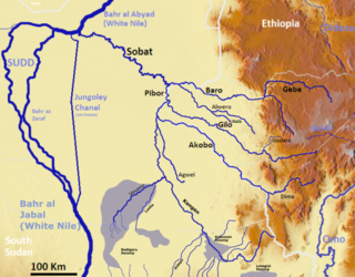
The Gilo River is a river in the Gambela Region of southwestern Ethiopia. A variety of names also knows it: the Gimira of Dizu call it the "Mene", while the Gemira of Chako call it "Owis", and Amhara and Oromo settlers in the early 20th century knew it by a third name, "Bako". From its source in the Ethiopian Highlands near Mizan Teferi it flows to the west, through Lake Tata to join the Pibor River on Ethiopia's border with Sudan. The combined waters then join the Sobat River and the White Nile.

The Gumara is a river of northern-western Ethiopia. It empties into Lake Tana into a bird's-foot delta from the east. Hot springs on the Gumara's banks at Wanzaye, which were popular in medicinal hot baths from the late 18th century till now, were already mentioned by missionary Henry Stern.
Jikawo River is a river of southwestern Ethiopia. It is a tributary of the Baro River, which it joins at latitude and longitude 8°22′N33°46′E.
The Sor is a river of southwestern Ethiopia. A tributary of the Birbir River on its left side and joins it at latitude and longitude 8°30′48″N35°11′17″E, the Sor rises in Sayo.
The Yabus River rises in the far west of Ethiopia, in Asosa Zone, flows west into Sudan past the town of Yabus, then enters South Sudan. At the town of Bunj it turns south west and enters the Machar Marshes, where it loses its identity.
The Gebba is a river of southwestern Ethiopia. It is a tributary of the Baro River, which is created at the confluence of the Gebba and the Birbir. The river is the planned site for the twin Gebba Hydro electric power dams.
The Daga River is a river in South Sudan. It rises in the mountains of the Mirab Welega Zone in Ethiopia, just east of the South Sudan-Ethiopia border, where it is known as the Deqe Sonka Shet. It flows west past the town of Daga Post and discharges into the Machar Marshes.
Anyuak Zone or Anywaa Zone is a zone in Gambela Region of Ethiopia. It was created from former Administrative Zone 1 and Administrative Zone 2 of Gambela. This zone is bordered on the southwest by South Sudan, on the southeast by the Southern Nations, Nationalities, and Peoples Region, on the east by Majang Zone, on the northeast by the Oromia Region, and on the northwest by South Sudan and Nuer Zone. Towns in this zone include Gambela, Abwobo and Pinyudo.
