Amet Sound

Last updated

Amet Sound is a large body of water, an embayment of the Northumberland Strait, on the north shore Nova Scotia straddling Colchester and Pictou counties. [1] It takes its name from Amet Island, a small island just beyond the mouth of the sound in Northumberland Strait. [2] Because of its sheltered position, its bays and harbours are considered "safe haven" for yachts in the event of major storms. [3]

Contents

Geography

Aerial view of Tatamagouche, looking north-northwest along the Waugh River toward Tatamagouche Bay and Amet Sound. Tatamagouche Aerial.jpg
Aerial view of Tatamagouche, looking north-northwest along the Waugh River toward Tatamagouche Bay and Amet Sound.

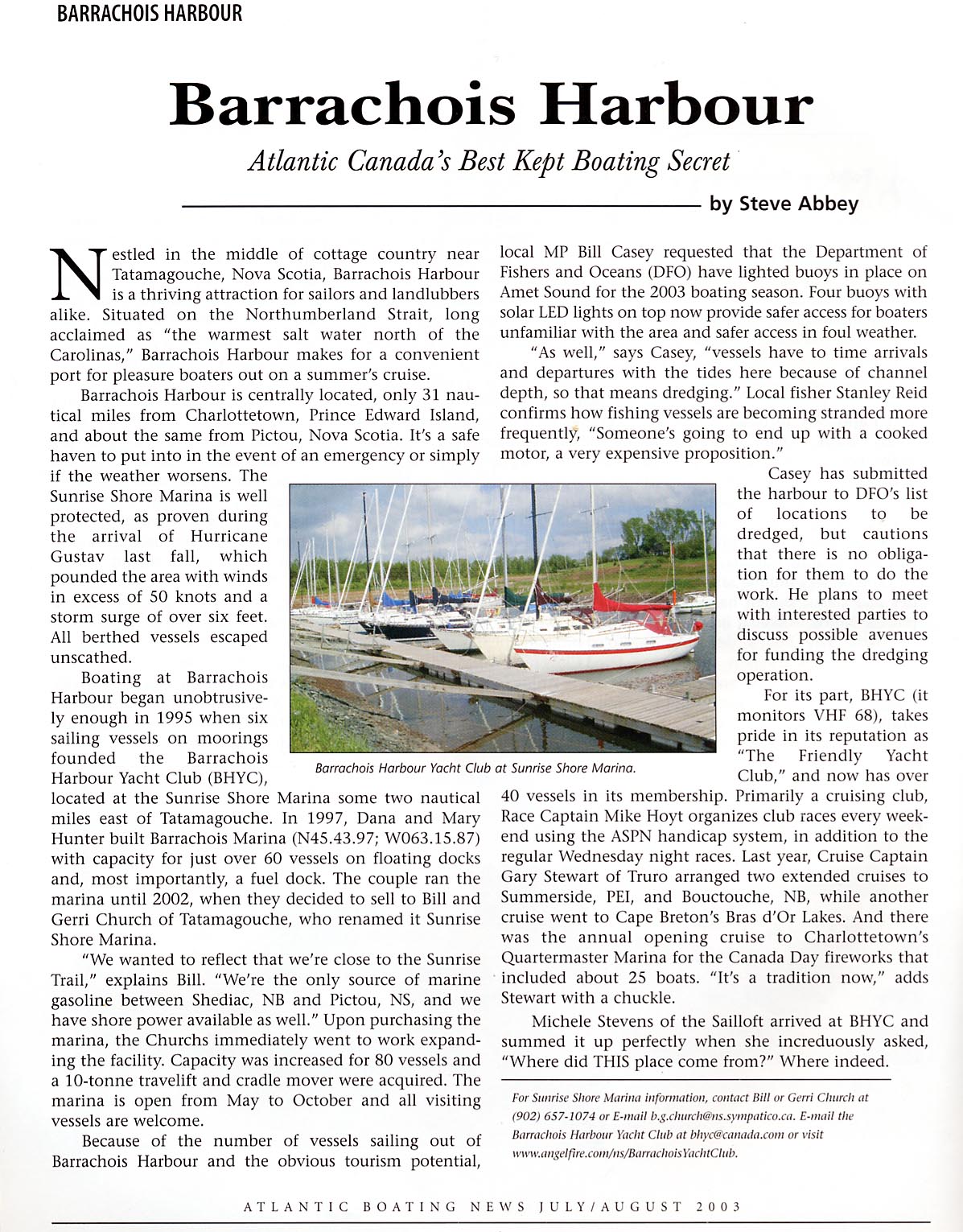
Extending 19 kilometres (12 mi) east to west and 7.8 kilometres (4.8 mi) north to south, this wide and shallow sound is separated from the Northumberland Strait by Malagash Point peninsula on the west and Cape John on the east. Its inland extensions include Tatamagouche Bay to the west-southwest, Barrachois Harbour to the southwest, Brule Harbour to the south and John Bay to the southeast. In total it has an area of 112.2 square kilometres (43.3 sq mi) and a perimeter of 84 kilometres (52 mi), with a maximum depth of 12.5 metres (41 ft). The mean tidal range is 1.6 metres (5.2 ft) with large tides measuring over 2.5 metres (8.2 ft) The watershed measures 971.7 square kilometres (375.2 sq mi) and the major streams draining the watershed are the Waugh River and River John. [4]

Cultural aspects

Surrounding land uses are mostly agricultural and recreational. The Barrachois Harbour Yacht Club is the focus of most recreational boating on the Sound. A Tim Horton Children's Camp is situated on Tatamagouche Bay, while Nelson Memorial Park, a municipal picnic park and floral garden is situated near Tatamagouche and the Rushtons Beach provincial day use park is located in Marshville. [5] [6] The main populated centres are at Tatamagouche on the Waugh River, and River John at the extreme easterly end of the sound. Historically, the area had numerous lobster canneries which were active in the first quarter of the twentieth century. [7]

Related Research Articles

<span class="mw-page-title-main">Gulf of St. Lawrence</span> Outlet of the North American Great Lakes via the St. Lawrence River into the Atlantic Ocean

The Gulf of St. Lawrence is the outlet of the North American Great Lakes via the St. Lawrence River into the Atlantic Ocean. The gulf is a semi-enclosed sea, covering an area of about 226,000 square kilometres (87,000 sq mi) and containing about 34,500 cubic kilometres (8,300 cu mi) of water, at an average depth of 152 metres (500 ft).

<span class="mw-page-title-main">Northumberland Strait</span> Strait between Prince Edward Island, New Brunswick and Nova Scotia

The Northumberland Strait is a strait in the southern part of the Gulf of Saint Lawrence in eastern Canada. The strait is formed by Prince Edward Island and the gulf's eastern, southern, and western shores.

<span class="mw-page-title-main">Pugwash, Nova Scotia</span> Village in Nova Scotia, Canada

Pugwash is an incorporated village in Cumberland County, Nova Scotia, Canada, located on the Northumberland Strait at the mouth of the Pugwash River. It had a population of 746 as of the 2021 census. The name Pugwash is derived from the Mi'kmaq word, Pakwesk meaning "a shoal", in reference to a reef near the mouth of the harbour.

Tatamagouche is a village in Colchester County, Nova Scotia, Canada.

<span class="mw-page-title-main">Bedford Basin</span>

Bedford Basin is a large enclosed bay, forming the northwestern end of Halifax Harbour on Canada's Atlantic coast. It is named in honour of John Russell, 4th Duke of Bedford.

<span class="mw-page-title-main">Halifax Harbour</span> Harbour in Canada

Halifax Harbour is a large natural harbour on the Atlantic coast of Nova Scotia, Canada, located in the Halifax Regional Municipality. Halifax largely owes its existence to the harbour, being one of the largest and deepest ice-free natural harbours in the world. Before Confederation it was one of the most important commercial ports on the Atlantic seaboard. In 1917, it was the site of the world's largest man-made accidental explosion, when the SS Mont-Blanc blew up in the Halifax Explosion of December 6.

Wallace is a rural community in Cumberland County, Nova Scotia, Canada.

<span class="mw-page-title-main">Musquodoboit River</span> River in Nova Scotia, Canada

The Musquodoboit River is a Canadian river located in central Nova Scotia in the northeastern part of Halifax Regional Municipality. The river is approximately 97 kilometres (60 mi) in length with roughly 88 kilometres (55 mi) being traversable by paddle. It has a watershed area of 1,409 square kilometres (544 sq mi)

<span class="mw-page-title-main">Nova Scotia Trunk 6</span>

Trunk 6 is part of the Canadian province of Nova Scotia's system of trunk highways. The route runs from Highway 104 exit 3 at Amherst to the rotary at Pictou, a distance of 136 kilometres (85 mi). It is part of the Sunrise Trail, a designated tourist route.

<span class="mw-page-title-main">Sunrise Trail</span>

The Sunrise Trail is a scenic roadway in the Canadian province of Nova Scotia. It is located along the province's North Shore on the Northumberland Strait for 333 km (207 mi) from Amherst to the Canso Causeway.

<span class="mw-page-title-main">Nova Scotia Route 311</span>

Route 311 is a collector road in the Canadian province of Nova Scotia.

<span class="mw-page-title-main">Geography of Nova Scotia</span>

Nova Scotia is a province located in Eastern Canada fronting the Atlantic Ocean. One of the Maritime Provinces, Nova Scotia's geography is complex, despite its relatively small size in comparison to other Canadian provinces.

<span class="mw-page-title-main">Brule, Nova Scotia</span> Human settlement in Nova Scotia, Canada

Brule is a rural community located in Colchester County, Nova Scotia, Canada.

<span class="mw-page-title-main">River John</span> River in Nova Scotia, Canada

River John is a river in Nova Scotia. Draining the extreme western part of Pictou County, it flows into Amet Sound on the Northumberland Strait at River John, a village which takes its name from the river. The Miꞌkmaq name is Kajeboogwek. An early name was Deception River. Its present name is believed to derive from Rivière Jaune, an Acadian name, though it may also derive from nearby Cap Jean. DesBarres called it River John in his Atlantic Neptune.

Barrachois is a small community in the Canadian province of Nova Scotia, located in Colchester County just east of the village of Tatamagouche and is the home of the Barrachois Harbour Yacht Club as well as a fishing wharf and launch ramp for pleasure craft.

<span class="mw-page-title-main">Barrachois Harbour Yacht Club</span>

The Barrachois Harbour Yacht Club (BHYC) was founded in 1996 and is a private, registered, not-for-profit yacht club located in Barrachois Harbour, northern Nova Scotia, Canada, 1.58 nautical miles east-northeast of the village of Tatamagouche, with access to the Northumberland Strait across Amet Sound.

<span class="mw-page-title-main">Pictou Group</span>

The Pictou Group is a stratigraphical unit of Late Carboniferous to Permian age in the Cumberland Basin of Atlantic Canada.

<span class="mw-page-title-main">Povungnituk River</span> River in Quebec, Canada

The Rivière de Puvirnituq is a river in Kativik, Nord-du-Québec, Quebec, Canada. The river flows 389 kilometres (242 mi) from its source at an unnamed lake to Hudson Bay at the village of Puvirnituq. Its watershed encompasses 28,500 square kilometres (11,000 sq mi). The name of the river comes from the Inuktitut "smells like rotten meat."

The Philadelphia grant describes 200,000 acres (81,000 ha) of land along the south shore of the Northumberland Strait between Tatamagouche and Pictou, Nova Scotia. Following expulsion of the Acadians, the British government distributed Acadian land to various landlords under the condition those landlords oversee repopulation of those lands with colonists loyal to King George III of the United Kingdom.

References

  1. "Amet Sound". Geographical Names Board of Canada . Natural Resources Canada . Retrieved 13 January 2018.
  2. Bill Hamilton, Place Names of Atlantic Canada, University of Toronto Press, 1996, p. 283
  3. Steve Abbey, Barrachois Harbour: Atlantic Canada's Best Kept Boating Secret, Atlantic Boating News, July/August 2003. Accessed January 6, 2015.
  4. Amet Sound Archived August 14, 2014, at the Wayback Machine Fisheries and Oceans Canada. Accessed January 6, 2015.
  5. Nelson Memorial Park Archived January 7, 2015, at the Wayback Machine , Municipality of Colchester County]
  6. Rushtons Beach Provincial Park
  7. "1820 - 1920. A Century of Industry on the North Shore of Nova Scotia: Wallace to River John", Sunrise Trail Museum (Virtual Museum), Accessed January 6, 2015

Coordinates: 45°47′N63°12′W / 45.783°N 63.200°W / 45.783; -63.200