Amrokkang Line

Last updated
Amrokkang Line
Overview
Other name(s)Sup'ung Hoan Line
Native name압록강선 (鴨緑江線)
Type Heavy rail, Freight rail
StatusOperational
Locale North P'yŏngan
Termini Pup'ung
Amrokkang
Stations2
Operation
Opened30 September 1940
Owner P'yŏngbuk Railway (1940-1945)
Korean State Railway (since 1945)
Technical
Line length4.1 km (2.5 mi)
Number of tracksSingle track
Track gauge 1,435 mm (4 ft 8 12 in) standard gauge
Route map

Contents

BSicon fSTRq.svg
BSicon uSTRq.svg
BSicon STRq.svg
Amrokkang Line
BSicon fCONTgq.svg
BSicon KBHFaq.svg
BSicon fSTRq.svg
BSicon STR+r.svg
BSicon uSTRq.svg
BSicon uSTRq.svgBSicon uSTRq.svgBSicon uSTR+r.svg
0.0
Pup'ung
BSicon WASSERq.svgBSicon WASSERq.svgBSicon hKRZWae.svgBSicon WASSERq.svgBSicon WASSER+r.svg
BSicon uSHI1r.svg
BSicon fSPLa.svg
(bridge appx 75 m (246 ft))
BSicon RP1q.svgBSicon RP1q.svgBSicon SKRZ-G1BUE.svgBSicon RP1+r.svgBSicon WASSER.svg
BSicon fv-STRl.svg
BSicon uSHI1+r.svg
BSicon fCONTfq.svg
BSicon STR.svgBSicon RP1eRP1.svg
BSicon RP1q.svg
BSicon RP2oWq.svg
BSicon uBUE.svg
BSicon RP1q.svg
BSicon RP1q.svg
BSicon STR.svgBSicon RP1.svgBSicon WASSER.svg
BSicon ulBHF~L.svg
BSicon uSTRl.svg
BSicon ulBHF~R.svg
BSicon uSTR+r.svg
BSicon WASSER.svg
2.5
Sup'ung
BSicon STR.svgBSicon RP1.svgBSicon WASSERl.svgBSicon WASSERq.svgBSicon uhKRZWae.svgBSicon WABZgr.svg
BSicon STRl.svg
BSicon STR+r.svg
BSicon RP1l.svg
BSicon RP1+r.svgBSicon uSTR+l.svg
BSicon uSTRr.svg
BSicon WASSER+l.svg
BSicon WASSERr.svg
BSicon tSTRa.svgBSicon RP1.svgBSicon uSTR.svgBSicon WASSER.svg
(tunnel appx 185 m (607 ft))
BSicon RP1+l.svg
BSicon RP1q.svg
BSicon tSTRe@f.svg
BSicon RP1rf.svgBSicon uSTR.svgBSicon WASSER.svg
BSicon RP1l.svg
BSicon STRl.svg
BSicon RP1+r.svg
BSicon STR+r.svgBSicon uSTR.svgBSicon WASSER.svg
BSicon tRP1ae.svgBSicon TUNNEL1.svgBSicon uSTR.svgBSicon WASSER.svg
(tunnel appx 60 m (200 ft))
BSicon RP1.svgBSicon STR.svgBSicon uENDEe.svgBSicon WASSER.svg
BSicon RP1l.svg
BSicon STRl.svg
BSicon RP1+r.svg
BSicon STR+r.svgBSicon WASSER.svg
BSicon tSTR+l.svg
BSicon RP1.svg
BSicon tSTRe@fq.svg
BSicon xABZgr.svgBSicon WASSER.svg
(tunnel appx 605 m (1,985 ft))
BSicon tSTRe.svgBSicon RP1.svgBSicon exKBSTe.svgBSicon WFALLg.svg
BSicon KBSTe.svgBSicon RP1.svgBSicon WASSER+l.svgBSicon WASSERr.svgBSicon WORKS.svg
4.1
Amrokkang
BSicon WASSERq.svgBSicon WASSERq.svgBSicon WASSERq.svgBSicon WASSERq.svgBSicon WASSERq.svgBSicon WASSERq.svgBSicon WASSERr.svg
Amrokkang Line
Chosŏn'gŭl
압록강선
Hancha
Revised Romanization Amnokgang-seon
McCune–Reischauer Amrokkang-sŏn

The Amrokkang Line is a non-electrified freight-only railway line of the Korean State Railway in North P'yŏngan Province, North Korea, running from Pup'ung on the P'yŏngbuk Line to Amrokkang Station on the Yalu River. [1]

Korean State Railway

The Korean State Railway is the operating arm of the Ministry of Railways of the Democratic People's Republic of Korea and has its headquarters at P'yŏngyang. The current Minister of Railways is Jang Hyuk, who has held the position since 2015.

North Pyongan Province Province in Kwansŏ, North Korea

North Pyongan Province, written before 1925 in English as Yeng Byen) is a western province of North Korea. The province was formed in 1896 from the northern half of the former P'yŏng'an Province, remained a province of Korea until 1945, then became a province of North Korea. Its capital is Sinŭiju. In 2002, Sinŭiju Special Administrative Region—near the city of Sinuiju—was established as a separately governed Special Administrative Region.

North Korea Sovereign state in East Asia

North Korea, officially the Democratic People's Republic of Korea, is a country in East Asia constituting the northern part of the Korean Peninsula, with Pyongyang the capital and the largest city in the country. The name Korea is derived from Goguryeo which was one of the great powers in East Asia during its time, ruling most of the Korean Peninsula, Manchuria, parts of the Russian Far East and Inner Mongolia, under Gwanggaeto the Great. To the north and northwest, the country is bordered by China and by Russia along the Amnok and Tumen rivers; it is bordered to the south by South Korea, with the heavily fortified Korean Demilitarized Zone (DMZ) separating the two. Nevertheless, North Korea, like its southern counterpart, claims to be the legitimate government of the entire peninsula and adjacent islands.

History

Originally called the Sup'ung Hoan Line, it was opened by the P'yŏngbuk Railway on 30 September 1940. [2]

Following the partition of Korea the line was located within the Soviet zone of occupation, and was nationalised along with all the other railways in the zone by the Provisional People’s Committee for North Korea on 10 August 1946, [1] becoming part of the Korean State Railway.

Soviet Union 1922–1991 country in Europe and Asia

The Soviet Union, officially the Union of Soviet Socialist Republics (USSR), was a socialist state in Eurasia that existed from 30 December 1922 to 26 December 1991. Nominally a union of multiple national Soviet republics, its government and economy were highly centralized. The country was a one-party state, governed by the Communist Party with Moscow as its capital in its largest republic, the Russian Soviet Federative Socialist Republic. Other major urban centres were Leningrad, Kiev, Minsk, Alma-Ata, and Novosibirsk.

Services

Logs floated down the Yalu River in log rafts are loaded onto trains at Amrokkang Station, from where they are shipped to the rest of the country. [3]

Timber rafting log transportation method in which logs are tied together into rafts and drifted or pulled across a water body or down a flatter river

Timber rafting is a log transportation method in which logs are tied together into rafts and drifted or pulled across a water body or down a river. It is arguably the second cheapest method of transportation of timber, next after log driving. Both methods may be referred to as timber floating.

Route

A yellow background in the "Distance" box indicates that section of the line is not electrified.

Distance (km)Station NameFormer Name
TotalS2STranscribedChosŏn'gŭl (Hanja)TranscribedChosŏn'gŭl (Hanja)Connections
0.00.0Pup'ung부풍 (富豊) P'yŏngbuk Line, Sup'ung Line
4.14.1Amrokkang압록강 (鴨緑江)Sup'ung Hoan수풍호안 (水豊湖岸)

Related Research Articles

Yalu River river on the border between North Korea and China

The Yalu River, also called the Amrok River or Amnok River, is a river on the border between North Korea and China. Together with the Tumen River to its east, and a small portion of Paektu Mountain, the Yalu forms the border between North Korea and China and is notable as a site involved in military conflicts such as the First Sino-Japanese War, the Russo-Japanese War, World War II, and the Korean War.

Sinuiju Municipal City in North Pyŏngan, North Korea

Sinŭiju ; Sinŭiju-si, known before 1925 in English as Yeng Byen City) is a city in North Korea which faces Dandong, China across the international border of the Yalu River. It is the capital of North P'yŏngan province. Part of the city is included in the Sinŭiju Special Administrative Region, which was established in 2002 to experiment with introducing a market economy.

Wiwon County County in Chagang Province, North Korea

Wiwŏn County is a kun, or county, in northern Chagang province, North Korea. It stands across the Yalu River from the People's Republic of China. It was originally part of North P'yŏngan province, but was annexed to Chagang in 1954. It borders Manp'o and Sijungto the north, Kanggye and Songgan to the east, Ch'onch'ŏn to the southeast, Kop'ung to the south and west, and Ch'osan to the west.

Sakchu County County in North Pyŏngan, North Korea

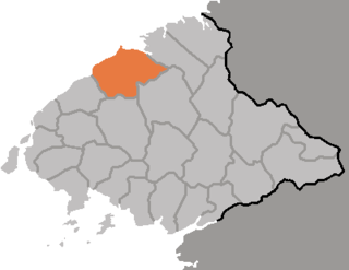
Sakchu County is a kun, or county, in northern part of North P'yŏngan province, in North Korea. It lies along the Yalu River bordering the People's Republic of China to the north. Within North Korea, it borders Ch'angsŏng to the east, Ch'ŏnma and Taegwan to the south, and Ŭiju to the west.

Chongju Chongnyon Station

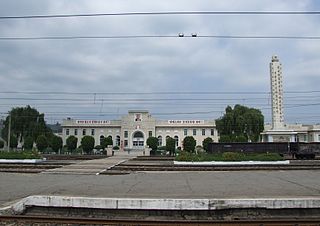
Chŏngju Ch'ŏngnyŏn Station is a railway station in Yŏkchŏn-dong, Chŏngju city, North P'yŏngan Province, North Korea. It is the junction of the P'yŏngŭi and P'yŏngbuk lines of the Korean State Railway.

Sohae Line

The Sŏhae Line, also known as the Anju Colliery Line, is a partially electrified standard-gauge secondary line of the Korean State Railway in South P'yŏngan Province, North Korea, running from Mundŏk on the P'yŏngŭi Line to Hwap'ung. The line is electrified between Mundŏk and P'yŏngnam Sŏho and between Ch'ŏngnam and Sŏsi.

Pyongbuk Line

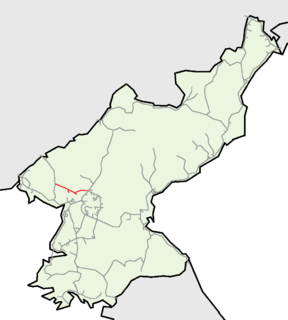
The P'yŏngbuk Line is an electrified standard-gauge secondary trunk line of the Korean State Railway in North Pyŏngan Province, North Korea, running from Chŏngju on the P'yŏngŭi Line to Ch'ŏngsu; it meets the Ch'ŏngnyŏn P'arwŏn Line at Kusŏng, and at Ch'ŏngsu, via a bridge across the Yalu River, it goes to Shanghekou, China, where it connects to China Railway's Fengshang Railway to Fenghuangcheng.

Paechon Line The railway which connects Haeju with Paechon in DPRK.

The Paech'ŏn Line is a partially electrified standard-gauge secondary railway line of the Korean State Railway in South Hwanghae Province, North Korea, running from Changbang on the Hwanghae Ch'ŏngnyŏn Line to Ŭnbit.

Chongnyon Parwon Line railway which connects Kujang with Kusong in DPRK.

The Ch'ŏngnyŏn P'arwŏn Line is a non-electrified standard-gauge secondary railway line of the Korean State Railway in North P'yŏngan Province, North Korea, running from Kujang on the Manp'o and P'yŏngdŏk Lines to Kusŏng on the P'yŏngbuk Line.

The Pyeongbuk Railway was a privately owned railway company in Japanese-occupied Korea.

Chongsu Station

Ch'ŏngsu Station is a railway station of the Korean State Railway in Ch'ŏngsu Workers' District, Sakchu County, North P'yŏngan Province, North Korea. It is the northern terminus of the P'yŏngbuk Line of the Korean State Railway. The line continues past the station to a factory at Namsal-li.

Pup'ung Station is a railway station of the Korean State Railway in Pup'ung, Sakchu County, North P'yŏngan Province, North Korea, on P'yŏngbuk Line of the Korean State Railway. It is also the starting point of the Sup'ung Line and the Amrokkang Line.

Supung Station

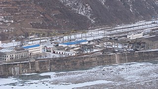
Sup'ung Station is a railway station of the Korean State Railway in Sup'ung Workers' District, Sakchu County, North P'yŏngan Province, North Korea; it is the terminus of the Sup'ung Line of the Korean State Railway.

Amrokkang Station is a freight-only railway station of the Korean State Railway in Hoan, Sup'ung Workers' District, Sakchu County, North P'yŏngan Province, North Korea; it is the terminus of the Amrokkang Line of the Korean State Railway.

Kusŏng Station is a railway station of the Korean State Railway in Yŏkchŏn-dong, Kusŏng city, North P'yŏngan Province, North Korea, on the P'yŏngbuk Line of the Korean State Railway. It is also the western terminus of the Ch'ŏngnyŏn P'arwŏn Line.

The Taegwalli Line is a non-electrified railway line of the Korean State Railway in Taegwan County, North P'yŏngan Province, North Korea, running from Sinon on the P'yŏngbuk Line to Taegwalli Station, a private station for Korean Workers Party officials.

Supung Line

The Sup'ung Line is an electrified railway line of the Korean State Railway in North P'yŏngan Province, North Korea, running from Pup'ung on the P'yŏngbuk Line to Sup'ung.

Unbong Line

The Unbong Line is a secondary railway line of the Korean State Railway located entirely within Unbong-rodongjagu, Chasŏng County, Chagang, North Korea, running from Sangp'unggang on the Pukpu Line to Kuunbong.

Kuunbong Station

Kuunbong Station is a freight-only railway station in Unbong-rodongjagu, Chasŏng County, Chagang Province, North Korea; adjacent to the Chasŏng Dam on the Yalu River, it is the terminus of the Unbong Line of the Korean State Railway.

The Yangsi Line was a non-electrified standard-gauge railway line of the Korean State Railway in North P'yŏngan Province, North Korea, running from Namsi (Yŏmju) on the P'yŏngŭi Line to South Sinŭiju, likewise on the P'yŏngŭi Line, with which it was merged in 1964.

References

  1. 1 2 Kokubu, Hayato, 将軍様の鉄道 (Shōgun-sama no Tetsudō) ISBN   978-4-10-303731-6
  2. 朝鮮總督府官報 (The Public Journal of the Governor-General of Korea), Shōwa Nr. 4114, 7 October 1940
  3. North Korea Geographic Information: Transportation Geography - P'yŏngbuk Line (in Korean)