Zahir Raihan was a Bangladeshi novelist, writer and filmmaker. He is most notable for his documentary Stop Genocide (1971), made during the Bangladesh Liberation War. He was posthumously awarded Ekushey Padak in 1977 and Independence Day Award in 1992 by the Government of Bangladesh.

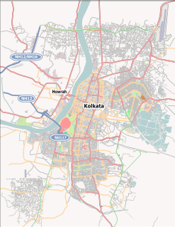
South 24 Parganas or sometimes South Twenty Four Parganas is a district in the Indian State of West Bengal, headquartered in Alipore. It is the largest district of West Bengal state by area and second largest by population. It is the sixth most populous district in India. On one side is the urban fringe of Kolkata and on the other, the remote riverine villages in the Sundarbans.
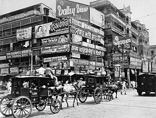
West Bengal is the state with highest population density in India. The state is dotted with several small and medium towns and cities. Historically, the main source of income of the people of West Bengal has been farming, and, as a consequence, the state previously had a large rural population skew. At the turn of the 20th century, however, the role of industry in West Bengal increased substantially, leading to a population move into urban areas.

Amtala is a census town under Bishnupur police station of Bishnupur II CD Block in Alipore Sadar subdivision of South 24 Parganas district in the Indian State of West Bengal. It is a part of Kolkata Urban Agglomeration.
Abu Naser Muhammad Gaziul Haque was a language activist and an activist leader during the Bengali Language Movement.
Oli Ahad was a Bangladeshi politician and language activist of the Language Movement. He was awarded Independence Day Award in 2004 by the Government of Bangladesh.
Joka is a locality in South West Kolkata, India.
Barhampur subdivision is an administrative subdivision of Murshidabad district in the state of West Bengal, India.
Alipore Sadar subdivision is a subdivision of South 24 Parganas district in the Indian State of West Bengal. It consists of three municipalities and five community development blocks. The five community development blocks contain 36 census towns and 45 gram panchayats. Apart from these, a large parts of Kolkata Municipal Corporation fall in this subdivision. The subdivision has its headquarters in Alipore.
Naoda is a community development block that forms an administrative division in Barhampur subdivision of Murshidabad district in the Indian state of West Bengal.

South Bengal is a term used for the southern parts of Bengal including Southern Bangladesh and Southern West Bengal.
Bishnupur II is a Community Development Block that forms an administrative division in Alipore Sadar subdivision of South 24 Parganas district in the Indian State of West Bengal.

Jatindra Rajendra Mahavidyalaya, also known as Amtala College established in 1986, is a general degree college of Amtala in Murshidabad district. It offers undergraduate courses in arts. It is affiliated to University of Kalyani.
Naoda is a town, not identified in 2011 census, with a police station, in Naoda CD Block in Barhampur subdivision of Murshidabad district in the state of West Bengal, India.
Hariharpara is a village, with a police station, in Hariharpara CD Block in Barhampur subdivision of Murshidabad district in the state of West Bengal, India.
Amtala is a town, with a college, not identified in 2011 census, in Naoda CD Block in Barhampur subdivision of Murshidabad district in the state of West Bengal, India.
Amtala is a census town in South 24 Parganas district in the Indian state of West Bengal.
Amtala High School is a secondary and higher secondary educational school located at Amtala, Naoda, Murshidabad District, West Bengal, India.
Amtala Annadamani Balika Vidyalaya is a secondary and higher secondary educational high school located in Amtala, Naoda, Murshidabad, India.


