
Effingham is a city in and the county seat of Effingham County, Illinois, United States. It is in South Central Illinois. Its population was 12,252 at the 2020 census. The city is part of the Effingham, IL Micropolitan Statistical Area.

Lakshmipur, also spelt Laxmipur, with an area of 1455.96 km2, is a district of Bangladesh. It is bordered by Chandpur to the north, Bhola and Noakhali districts to the south, Noakhali to the east, and Barisal and Bhola districts to the west. Lakshmipur was the part of Noakhali until 15 February 1984.
Rangia is a city and a municipal board in Kamrup rural district in the Indian state of Assam. It is the regional divisional headquarters of the Northeast Frontier Railway. It is situated 52 kilometres away from the state headquarters Dispur Guwahati and 39 kilometres from Jalukbari.
Melvisharam is a town and suburb of Vellore city in the Indian state of Tamil Nadu. It is 7 kilometres from Ranipet, 5 km from historic town of Arcot and 17 km from Vellore city.
Sandwip is an upazila of Chattogram District in Chattogram Division, Bangladesh. It encompasses the islands of Sandwip and Urir Char.
Chatkhil is an upazila of Noakhali District in the Division of Chittagong, Bangladesh. It is bounded by Laksham and Shahrasti Upazila on the north, Lakshmipur Sadar Upazila on the south, Begumganj Upazila on the east, and Ramgonj Upazila on the west. Chatkhil thana was formed in 1977 and was upgraded into an upazila in 1983.
Bhairab is a upazila of Kishoreganj District in the Division of Dhaka, Bangladesh. Joanshahi was another name of Bhairab. The city centre of this upazila is Bhairab Bazaar. About 118,992 people live in Bhairab municipality which makes this city the largest in Kishoreganj District and 28th largest city in Bangladesh.
Gafargaon is an upazila of Mymensingh District in the Division of Mymensingh, Bangladesh.
Narayanganj Sadar is an upazila of Narayanganj District in the Division of Dhaka, Bangladesh.
Alamdanga is an upazila of Chuadanga District in the Division of Khulna, Bangladesh. It covers an area of 380.38 square kilometres (146.87 sq mi).
Keshabpur is an upazila of Jessore District in the Division of Khulna, Bangladesh.
Maheshpur Upazila is a part of Jhenaidah District in the Khulna Division of Bangladesh.
Dupchanchia Upazila is an upazila of Bogura District in the Division of Rajshahi, Bangladesh. Dupchanchia Thana was established in 1880 and was converted into an upazila in 1983. It is named after its administrative center, the town of Dupchanchia.
Mithapukur is an upazila of Rangpur District in the division of Rangpur, Bangladesh. The upazila is situated in the middle of Rangpur, surrounded by Rangpur Sadar to the north, Pirganj to the south, Badarganj and Phulbari to the west and Pirgachha and Sundarganj to the east. Mithapukur is famous for being the birthplace of Begum Rokeya Sakhawat Hossain and its sweet mango Harivanga.
Shahjadpur is an upazila or sub-district of Sirajganj District in Rajshahi Division of Bangladesh.
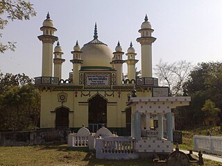
Furfura Sharif is a village in Jangipara community development block of Srirampore subdivision in Hooghly District in the state of West Bengal, India. It is a holy place for some Bengali Muslims. Before the afternoon prayers, people queue up at the mazar (shrine) of Mohammad Abu Bakr Siddique (1846-1939), a prominent pir of the town. People say it is the second most prominent mazar in the country after Ajmer Sharif Dargah in Rajasthan.
Kholagram Mathiura union is a union parishad in Beanibazar Upazila, Sylhet District, Bangladesh.
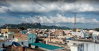
Pernambut is a town and village headquarters also a Municipality in Vellore district in the Indian state of Tamil Nadu. The economy is dependent on leather tanning industry, earning it the nickname Leather Tanning city of Tamil Nadu.Pernambut is a municipality and headquarters of Pernambut taluk which is an administrative division comprising 52 Revenue villages in the district of Vellore.
Ghola Noapara is a census town within the jurisdiction of the Usthi police station in the Magrahat I CD block in the Diamond Harbour subdivision of the South 24 Parganas district in the Indian state of West Bengal.
ʿAbd al-Wāḥid Bengālī was a 19th-century Muslim theologian, teacher and social reformer. He was one of the initiators of the Deobandi movement into Bengal, and co-founded Al-Jamiatul Ahlia Darul Ulum Moinul Islam in 1896.

