
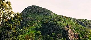
Yem Zone is one of the zones in the Central Ethiopia Regional State. Yem is named for the Yem, people whose homeland lies in this zone,. Yem is bordered on the west and north by the Oromia Region, and separated from Gurage on the northeast and Hadiya on the east by the Omo River. High points in Yem include Mount Bor Ama, Mount Azulu and Mount Toba. The administrative center of Yem is Saja.
Hadiya is a zone in the Central Ethiopia Regional State of Ethiopia. This zone is named after the Hadiya of the Hadiya Kingdom, whose homeland covers part of the administrative division. Hadiya is bordered on the south by Kembata, on the southwest by the Dawro Zone, on the west by the Omo River which separates it from Oromia Region and the Yem Special Woreda, on the north by Gurage, on the northeast by Silte, and on the east by the Alaba Zone; the woredas of Mirab Badawacho and Misraq Badawacho form an exclave separated from the rest of the zone by Kembata. The administrative center of Hadiya is Hosaena.
Kembata is a zone in the Central Ethiopia Regional State of Ethiopia. It was formerly known as Kembata, Alaba and Tembaro, until Alaba and Tembaro became a special woreda in 2002 and 2023 respectively. This zone is named after the Kambaata people which gained zonal posture following the establishment of Central Ethiopian region in 2023.
Amaro Zone (Kore) is a zone in the south-west Ethiopian Regional State of Ethiopia, and the people are called Kore, and their language is Korigna. The Amaro Kore people are the descendants of the Christian missioners of the north Ethiopian sematic peoples of Gonder, who were moved gradually through the northern shewa (menze) to the central and south-western Ethiopian lands of Damot (wolayta), Dawuro, Gamo Gofa, and surrounding areas of the region with their Christian traditions and heritages around the eleventh, twelfth, and thirteenth centuries. As the native of kore nation Theologian Jebdu kassahun evidentially assured and narrated, that was a time of ST. Abune Gebremenfes kidus, st.tekle Haymanot, and emperor Yikuno Amlak, who were preached and expanded Christianity to central and south western Ethiopian lands. Amaro is one of the areas in which members of Kore nations widely live in. Amaro Kore people got zonal status in August 2023 A.D upon the formation of the South west Ethiopia Regional State. In 2011 A.D, the Segen Area Peoples Zone was established, which includes Amaro woreda and the three former special woredas surrounding it. Located in the Great Rift Valley, Amaro kore peoples land is bordered on the south by Burji Zone, on the southwest by Konso Zone, on the west by Dirashe Zone, on the northwest by Gamo Zone and Lake Chamo, and on the north by Lake Abaya and in east and northeast by Oromia Region. It is divided into 35 kebeles. The administrative center of the woreda is Kelle, and Jijola woreda, Derba Menena woreda, and Kereda are other growing municipals of the zone. The highest peak in the zone is Mount Dello, which is part of the Kore mountains, the highest in Jemjem plateau and the second from the region. Much of the western part of this zone lies inside the Nechisar National Park. The major crops grown in Amaro are enset, teff, maize, wheat, barley, navy beans, and coffee. Amaro has 39 kilometers of all-weather roads and 16 kilometers of dry-weather roads, for an average road density of 36 kilometers per 1000 square kilometers. The Central Statistical Agency (CSA) reported that 1,082 tons of coffee were produced in the year ending in 2005, based on inspection records from the Ethiopian Coffee and Tea authority. This represented 0.48% of the Southern Nations, Nationalities and Peoples' Region (SNNPR)'s output and 1.08% of Ethiopia's total output.
Damot Gale is a woreda in South Ethiopia Regional State, Ethiopia. Part of the Wolayita Zone, Damot Gale is bordered on the southwest by Sodo Zuria, on the northwest by Boloso Sore and Damot Pulasa, on the north by the Hadiya Zone, on the east by Diguna Fango, and on the southeast by Damot Weyde. The administrative center of Damot Gale is Boditi. Damot Pulasa woreda was separated from Damot Gale.
Enemorina Eaner is one of the woredas in the Southern Nations, Nationalities, and Peoples' Region of Ethiopia. This woreda is named in part after one of the sub-groups of the Sebat Bet Gurage, the Enemor, who are first mentioned in a list of groups paying tribute to Emperor Yeshaq I, and other sub-group, Eaner. Part of the Gurage Zone, Enemorina Eaner is bordered on the south by the Hadiya Zone, on the southwest by Yem special woreda, on the west by Oromia Region, on the north by Cheha, on the east by Geta, and on the southeast by Endegagn. The administrative center of Enemorina Eaner is Gunchire. Endegagn was separated from this woreda.
Leemo is one of the woredas in the Central Ethiopia Regional State of Ethiopia. The relationship of the name of this woreda to that of the medieval kingdom in the Gibe region is unclear. A part of the Hadiya Zone, Limo is bordered on the south by the Kembata Tembaro Zone, on the southwest by Duna and Soro, on the west by Gomibora, on the northwest by Misha, on the northeast by Ana Lemo, and on the southeast by Shashogo. Towns in Lemo include Belesa and Lisana. The town of Hosaena is surrounded by Limo. Parts of Limo woreda were separated to create Ana Lemo, Hosaena, Mirab Azernet Berbere and Misraq Azernet Berbere woredas.
Badawacho was one of the 77 woredas in the Southern Nations, Nationalities, and Peoples' Region of Ethiopia. A triangle-shaped exclave of the Hadiya Zone, Badawacho was bordered on the south by the Wolayita Zone, on the west and north by the Kembata Tembaro Zone, and on the east by the Oromia Region and Sidama Zone. Badawacho has got three small lakes: Budamada - deepest of all three, Tiello and Matchafara - home for hippopotamus and variety of birds. The Bilate River which separates the three lakes is also home for crocodiles and hippopotamus. The major town in Badawacho was Shone. Badawacho was separated for Mirab Badawacho and Misraq Badawacho woredas.
Soro is one of the woredas in the Southern Nations, Nationalities, and Peoples' Region of Ethiopia. Part of the Hadiya Zone, Soro consists large population of Hadiya and Danta dubamo people, bordered on the south by the Kembata Tembaro Zone, on the southwest by the Dawro Zone, on the west by the Omo River which separates it from the Oromia Region, on the north by Gomibora, on the northeast by Limo, and on the southeast by Duna. The administrative center of this woreda is Gimbichu; other towns in Soro include Jajura. Parts of Soro were separated to create Duna and Gomibora woredas.
Omo Sheleko was one of 77 woredas in the Southern Nations, Nationalities, and Peoples' Region of Ethiopia. Part of the Kembata Alaba and Tembaro Zone, Omo Sheleko was bordered on the south by the Semien Omo Zone, on the west by the Omo River which separates it from another part of the Semien Omo Zone, on the north by the Hadiya Zone, and on the east by Kacha Bira. Towns in Omo Sheleko included Mudula and Tunto. Omo Sheleko was divided for Hadero Tunto and Tembaro woredas.
Kedida Gamela is a woreda in the Central Ethiopia Regional State of Ethiopia. Part of the Kembata Zone. Kedida Gamela is bordered on the east and south by an Misraq Badawacho woreda of the Hadiya Zone, on the west by Kacha Bira, on the northwest by Angacha, on the north by Damboya, and on the northeast by the Bilate River which separates it from Halaba Zone. The northern part of Kedida Gamela was separated to create Damboya woreda. The administrative center of the district is Durame.
Halaba is a zone in the Central Ethiopia Regional State. It is named after the Halaba people, and covers part of their homeland. Located in the Great Rift Valley, Halaba zone is bordered on the south by an exclave of Hadiya Zone, on the southwest by the Kembata Tembaro Zone, on the west and north by Hadiya Zone, on the north east by Lake Shala, and on the east by Oromia Region; the Bilate River, which is its major body of water, defines its western boundary. The administrative center is halaba Kulito.
Kacha Bira is a woreda in the Southern Nations, Nationalities, and Peoples' Region of Ethiopia. Part of the Kembata Tembaro Zone, Kacha Bira is bordered on the south by an exclave of the Hadiya Zone, on the southwest by the Wolayita Zone, on the west by Hadero Tunto, on the northwest by the Hadiya Zone, on the north by Doyogena and Angacha, and on the east by Kedida Gamela. Towns in Kacha Bira include Shinshicho and Hadero.
Shebedino is a woreda in Southern Nations, Nationalities, and Peoples' Region, Ethiopia. Part of the Sidama Zone located in the Great Rift Valley, Shebedino is bordered on the south by Dale, on the west by Boricha, on the north by Awasa Zuria, on the east by Gorche, and on the southeast by Wensho. Towns in Shebedino include Leku. Boricha and Gorche woredas were separated from Shebedino woreda.
Wenago is one of the woredas in the Southern Nations, Nationalities, and Peoples' Region of Ethiopia. Part of the Gedeo Zone, Wenago is bordered on the southwest by Yirgachefe, on the northwest by the Oromia Region, on the northeast by Dila Zuria, and on the southeast by Bule. Towns in Wenago include Wenago. Dila Zuria woreda and Dila town were separated from Wenago.
Kindo Koysha is a district in the South Ethiopia Regional State of Ethiopia. It is a Part of the Wolayita Zone, Kindo Koysha is bordered on the south by Offa, on the southwest by Kindo Didaye, on the west by the Dawro Zone, on the north by Boloso Bombe, on the west by Damot Sore, on the southwest by Kindo Didaye and on the southeast by Bayra Koysha. The administrative center of Kindo Koysha is Bale Hawassa. Kindo Didaye woreda was separated from Kindo Koysha.
Bure is one of the woredas in the Oromia Region of Ethiopia. Part of the Illubabor Zone, Bure is bordered on the south by Nono, on the southwest by the Gambela Region, on the west by the Kelem Welega Zone, on the northeast by Metu, and on the southeast by Ale; the Birbir River defines the west and north boundaries. Towns in Bure include Bure and Sibo. Huka Halu woreda was separated from Bure.
Seraro is one of the woredas in the Oromia Region of Ethiopia. Part of the West Arsi Zone located in the Great Rift Valley, Seraro is bordered on the south and west by the Southern Nations, Nationalities and Peoples' Region, on the north by Shala, and on the east by Naannawa Shashamane; its western boundary is defined by the course of the Bilate River. The administrative center of this woreda is Loke.
Fentale is one of the districts in the Oromia of Ethiopia. Part of the East Shewa Zone located in the Great Rift Valley, Fentale is bordered on the southeast by the Arsi Zone, on the southwest by Boset, on the northwest by the Amhara Region, and on the northeast by the Afar Region. The administrative center of Fentale is Metehara; other towns include Haroo Adii.
Arsi Negele is a woreda in Oromia Region, Ethiopia. It is named after its administrative center, Arsi Negele. Part of the West Arsi Zone located in the Great Rift Valley, Arsi Negele is bordered on the south by Naannawa Shashamane and Kofale, on the southwest by Lake Shala which separates it from Shala, on the west by the Southern Nations, Nationalities and Peoples Region, on the north by East Shewa with which it shares the shores of Lakes Abijatta and Langano, and on the east by the Heban Arsi, Qore woreda and small portion by Arsi Zone.