Aztec is a city in, and the county seat of, San Juan County, New Mexico, United States. As of the 2010 census, the city population was 6,763. The Aztec Ruins National Monument is located on the north side of the city.

The Grand Staircase–Escalante National Monument (GSENM) is a United States national monument originally designated in 1996 as 1,880,461 acres (7,610 km2) of protected land in southern Utah. In 2017, the monument's size was reduced by half in a succeeding presidential proclamation. The land is among the most remote in the country; it was the last to be mapped in the contiguous United States.

The Red Rock Canyon National Conservation Area in Clark County, Nevada, is an area managed by the Bureau of Land Management as part of its National Landscape Conservation System, and protected as a National Conservation Area. It is about 15 miles (24 km) west of Las Vegas, and is easily seen from the Las Vegas Strip. More than three million people visit the area each year.

Lake Mead National Recreation Area is a U.S. national recreation area in southeastern Nevada and northwestern Arizona. Operated by the National Park Service, Lake Mead NRA follows the Colorado River corridor from the westernmost boundary of Grand Canyon National Park to just north of the cities of Laughlin, Nevada and Bullhead City, Arizona. It includes all of the eponymous Lake Mead as well as the smaller Lake Mohave – reservoirs on the river created by Hoover Dam and Davis Dam, respectively – and the surrounding desert terrain and wilderness.
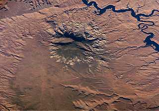
The San Rafael Swell is a large geologic feature located in south-central Utah, USA about 16 miles (26 km) west of Green River. The San Rafael Swell, measuring approximately 75 by 40 miles, consists of a giant dome-shaped anticline of sandstone, shale, and limestone that was pushed up during the Paleocene Laramide Orogeny 60–40 million years ago. Since that time, infrequent but powerful flash floods have eroded the sedimentary rocks into numerous valleys, canyons, gorges, mesas, buttes, and badlands.

Cleveland National Forest encompasses 460,000 acres, mostly of chaparral, with a few riparian areas. A warm dry mediterranean climate prevails over the forest. It is the southernmost U.S. National Forest of California. It is administered by the U.S. Forest Service, a government agency within the United States Department of Agriculture. It is divided into the Descanso, Palomar and Trabuco Ranger Districts and is located in the counties of San Diego, Riverside, and Orange.

The Hells Canyon Wilderness is a wilderness area in the western United States, in Idaho and Oregon. Created 46 years ago in 1975, the Wilderness is managed by both the U.S. Bureau of Land Management and the U.S. Forest Service and contains some of the most spectacular sections of the Snake River as it winds its way through Hells Canyon, North America's deepest river gorge and one of the deepest gorges on Earth. The Oregon Wilderness Act of 1984 added additional acreage and currently the area protects a total area of 217,927 acres (88,192 ha). It lies entirely within the Hells Canyon National Recreation Area except for a small 946-acre (383 ha) plot in southeastern Wallowa County, Oregon which is administered by the Bureau of Land Management. The area that is administered by the Forest Service consists of portions of the Wallowa, Nez Perce, Payette, and Whitman National Forests.
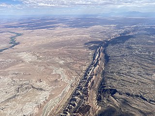
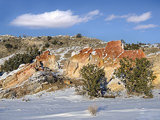
The Navajo Section is a physiographic section of the larger Colorado Plateaus Province, which in turn is part of the larger Intermontane Plateaus physiographic Division.

The Bisti/De-Na-Zin Wilderness is a 45,000-acre (18,000 ha) wilderness area located in San Juan County in the U.S. state of New Mexico. Established in 1984, the Wilderness is a desolate area of steeply eroded badlands managed by the Bureau of Land Management, with the exception of three parcels of private Navajo land within its boundaries. The John D. Dingell, Jr. Conservation, Management, and Recreation Act, signed March 12, 2019, expanded the Bisti/De-Na-Zin Wilderness by approximately 2,250 acres.

The Oregon Badlands Wilderness is a 29,301-acre (11,858 ha) wilderness area located east of Bend in Deschutes and Crook counties in the U.S. state of Oregon. The wilderness is managed by the Bureau of Land Management as part of the National Landscape Conservation System and was created by the Omnibus Public Land Management Act of 2009, which was signed into law by President Barack Obama on 30 March 2009.

The Santa Rosa Wilderness is a 72,259-acre (292.42 km2) wilderness area in Southern California, in the Santa Rosa Mountains of Riverside and San Diego counties, California. It is in the Colorado Desert section of the Sonoran Desert, above the Coachella Valley and Lower Colorado River Valley regions in a Peninsular Range, between La Quinta to the north and Anza Borrego Desert State Park to the south. The United States Congress established the wilderness in 1984 with the passage of the California Wilderness Act, managed by the both US Forest Service and the Bureau of Land Management. In 2009, the Omnibus Public Land Management Act was signed into law which added more than 2,000 acres (8.1 km2). Most of the Santa Rosa Wilderness is within the Santa Rosa and San Jacinto Mountains National Monument.
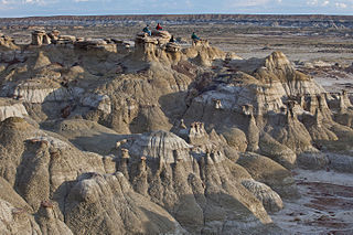
Ah-Shi-Sle-Pah Wilderness is located in San Juan County, New Mexico, between Chaco Canyon and the De-Na-Zin Wilderness. The wilderness has multicolored badlands, sandstone hoodoos, petrified wood and dinosaur bones, similar to those found in the nearby Bisti Badlands and De-Na-Zin Wilderness.

The Devils Garden of the Grand Staircase–Escalante National Monument (GSENM) in south central Utah, United States, is a protected area featuring hoodoos, natural arches and other sandstone formations. The area is also known as the Devils Garden Outstanding Natural Area within the National Landscape Conservation System.

The Rio Grande del Norte National Monument is an approximately 242,555-acre (98,159 ha) area of public lands in Taos County, New Mexico, proclaimed as a national monument on March 25, 2013 by President Barack Obama under the provisions of the Antiquities Act. It consists of the Rio Grande Gorge and surrounding lands, managed by the Bureau of Land Management (BLM).

Little Finland is a scenic red rock area, located in a remote section of Clark County, Nevada south of Mesquite, known for its red rock scenery and strangely-shaped, delicate rock formations. The landscape is similar to Valley of Fire State Park, which is about 20 miles (32 km) to the west, across Lake Mead. The rock formations are composed of red Aztec Sandstone, fossil sand dunes. Many of the features are small erosional fins, hence the name.

The Trail of the Ancients is a New Mexico Scenic Byway to prehistoric archaeological and geological sites of northwestern New Mexico. It provides insight into the lives of the Ancestral Puebloans and the Navajo, Ute, and Apache peoples. Geological features include canyons, volcanic rock features, and sandstone buttes. Several of the sites are scenic and wilderness areas with recreational opportunities.
Ojito Wilderness is a designated Wilderness Area in Sandoval County, New Mexico, administered by the U. S. Bureau of Land Management. Established in 2005, the 11,823 acre primitive area protects a rugged and austere landscape north of Albuquerque, and is open to primitive camping, hiking, and horseback riding.
Irish Canyon is a valley in Moffat County in northwestern Colorado at 6,099 feet [CONVERT?] in elevation according to United States Geological Survey (USGS). The Bureau of Land Management states that the elevations rise from 6,100 to 8,636 feet. It is a scenic canyon and somewhat remote. It is designated both as the Irish Canyon Natural Area and Irish Canyon Area of Critical Environmental Concern.

