
Thane district is a district in the Konkan Division of Maharashtra, India. At the 2011 Census it was the most populated district in the country, with 11,060,148 inhabitants; however, in August 2014 the district was split into two with the creation of a new Palghar district, leaving the reduced Thane district with a 2011 Census population of 11,060,148. The headquarters of the district is the city of Thane. Other major cities in the district are Navi Mumbai, Kalyan-Dombivli, Mira-Bhayander, Bhiwandi, Ulhasnagar, Ambarnath, Badlapur, Murbad and Shahapur.

Madurai district is one of the 38 districts of the state of Tamil Nadu in southeastern India. The city of Madurai serves as the district headquarters. It houses the famous Sri Meenakshi Sundareshwarar temple and is situated on the banks of the river Vaigai. Thiruparankundram is one of the major tourist place in the district. As of 2011, the district had a population of 3,038,252 with a sex-ratio of 990 females for every 1,000 males. Aside from the city of Madurai, the larger towns are Melur, Vadipatti, Thirumangalam, Thirupparankundram, Peraiyur, and Usilampatti. It is an important hub for various film shootings. Alanganallur is a popular spot in the district for Jallikattu, as are Palamedu and Avaniyapuram.

Anand District is an administrative district of Gujarat state in western India and whose popular nickname is Charotar. It was carved out of the Kheda district in 1997. Anand is the administrative headquarters of the district. It is bounded by Kheda District to the north, Vadodara District to the east, Ahmedabad District to the west, and the Gulf of Khambhat to the south. Major towns are Umreth, Khambhat, Karamsad, Tarapur, Petlad, Borsad and Sojitra.
Karamsad is a City and All the limits of Karamsad Municipality fall within the limits of Anand Municipal Corporation.. Anand Municipal Corporation limits are visible all around.. in Anand district in the Indian state of Gujarat. It is part of the Chhagaam Gol.
Bhadran is a village in the state of Gujarat, in far western India. It is in the Anand district. Bhadran was nicknamed the "Paris of Gaekwad state" due to its prosperity and civil works carried out by Maharaja Sayajirao Gaekwad III, the visionary ruler of Baroda. It has been called the greatest village in India by Vallabhbhai Patel.
Dahegam is a city and a municipality in the Gandhinagar district in the state of Gujarat, India.

Gurmitkal, or Gurumithakal, is a panchayat town in the northeast of Yadgir district in the Indian state of Karnataka. Administratively, it is under Gurumitkal Taluka.

Mohpa is a city with a municipal council in Nagpur district in the Indian state of Maharashtra. Although physically located within Kalmeshwar taluka, it is not subject to taluka governance. It is divided in to basically three part
Raybag is a taluka in Belgaum district in the Indian state of Karnataka. It derives its name from the two words namely "Rai" and "bagh" in which "Rai" means king and "bagh" means tiger.
Surgana is a census town and taluka in Nashik District in the Indian state of Maharashtra.
Tarsali is a census town in Vadodara district in the Indian state of Gujarat.
Thiruvennainallur is a taluk in Viluppuram district in the Indian state of Tamil Nadu. It is a major sugarcane agricultural region.
Khadki is a cantonment in the city of Pune, India. It has now flourished as a quasi-metropolis & centered in the northern region of the city.
Satana is a town and a municipal council in Nashik District in the Indian state of Maharashtra. It is in the taluka of Baglan, which is sometimes called Satana, because of the city's dominance in the taluka. The name "Satana" is derived from "Śāṭyāyani" one of the minor Upanishads of the Muktika canon.
Peth or Peint is the smallest tehsil of Nashik subdivision of Nashik district in Maharashtra, India. It belongs to Northern Maharashtra region. It belongs to Nashik Division. Peth is a Taluka headquarter. It is located 54 km to the West of Nashik District headquarters. It is also called as Peint. Pin code of Peth is 422208 and postal head office is Peth.
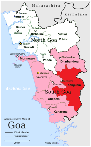
Sanguemtaluka is an administrative region of Goa state, India.

Ambegaon taluka is a taluka in Shirur subdivision of Pune district of state of Maharashtra in India. One of the twelve most revered Shiva temples or Jyotirlinga, the Bhimashankar Temple is in Khed taluka. But due to Bhimashankar Sanctuary, the road is through Ambegaon taluka.

Gadhinglaj is a taluka in Maharashtra. The city of Gadhinglaj is the taluka headquarters and Gadhinglaj subdivision headquarters as well. As of 2011, the taluka had a population of 874,015, of which 35% were urban. Languages spoken in this area are Marathi, Kannada, Hindi and English also. But the most-spoken language is Marathi, as Marathi is a state language.
Haladi is a Town in Gadhinglaj Taluka Kolhapur district situated in the southwest corner of state Maharashtra, India. Harali is situated on banks of Hiranyakeshi river originated from the Great Amboli Ghats is about 7 km from Gadhinglaj towards south and 12 km from the second largest city Kadgaon in Gadhinglaj Taluka and just 2 km from Mahagaon,Gadhinglaj. It is managed by Town Council.In 2011 it has a population of about 9,856. Harali is the eight largest city and town in Gadhinglaj Taluka. Shri Appasaheb Nalawade Gadhinglaj Taluka Sahakari Sakhar Karkhana is situated in the town.

Bhat is a village in Daskroi Taluka in Ahmedabad district of Gujarat State, India. Bhat is located near the bank of the Sabarmati River, 24 km towards west from District headquarters Ahmedabad, 5 km from Daskroi and 49 km from State capital Gandhinagar.

