
Panchkula district was formed as the 17th district of Haryana state in India on 15 August 1995. It comprises two sub divisions and two tehsils: Panchkula and Kalka. It has 264 villages out of which twelve are un-inhabited and ten wholly merged with towns or treated as census towns according to the 1991 census. There are five towns in the district: Barwala, Kalka, Panchkula, Pinjore and Raipur Rani. The total population of the district is 319,398 out of which 173,557 are males and 145,841 are females.
Sant Kabir Nagar district is one of the 75 districts of Uttar Pradesh state in northern India. Khalilabad city is the district headquarters. Sant Kabir Nagar district is a part of Basti division. The total area of Sant Kabir Nagar district is 1646 Sq. Km.

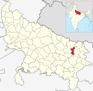
Kanpur Nagar district, meaning Urban Kanpur District is one of the districts of the Uttar Pradesh state of India. It is a part of Kanpur division and its district headquarters is Kanpur. Kanpur was formerly spelled Cawnpore.

Bathinda district is in Malwa region of Punjab, India. The districts encompass an area of 3,385 square kilometers. By area, Bathinda District is the third-largest in Punjab. It is bounded by Faridkot district and Moga district on the north, Mukatsar district on the west, Barnala and Mansa districts on the east, and the state of Haryana on the south. Bathinda is cotton producing belt of Punjab.

Rampur district is one of the districts of Uttar Pradesh state of India, and Rampur town is the district headquarters. Rampur district is a part of Moradabad division. The district occupies an area of 2,367 km2 (914 sq mi).
Kolami is a tribal Central Dravidian language spoken in Maharashtra and Telangana states of India. It falls under the Kolami–Naiki group of languages. It is the most widely spoken Central Dravidian language.

Bhogpur is a town and a nagar panchayat in Jalandhar district in the state of Punjab, India. Bhogpur is the first city from the overall india who created its own website on city name. Bhogpur sugar mill is first Co-operative sugar mill and still running successfully.

Injambakkam is a locality in the south of Chennai in the Indian state of Tamil Nadu. Being a part of the Walajabad block of the district, its panchayat is part of Walajabad panchayat union. Injambakkam is located along the ECR.

{{Infobox settlement | name = Raybag | other_name = Raibag | nickname = Bagi ur | settlement_type = town/taluka | image_skyline = | image_alt = | image_caption = | pushpin_map = India Karnataka#India3 | pushpin_label_position = right | pushpin_map_alt = | pushpin_map_caption = Location in Karnataka, India | coordinates = 16.48°N 74.78°E | subdivision_type = Country | subdivision_name = India | subdivision_type1 = State | subdivision_name1 = Karnataka | subdivision_type2 = District | subdivision_name2 = Belgaum | established_title = | established_date = | founder = | named_for = | government_type = | governing_body = Nagar Palika | unit_pref = Metric | area_footnotes = | area_rank = | area_total_km2 = | elevation_footnotes = | elevation_m = 590 | population_total = 18,984 | population_as_of = 2011 | population_rank = | population_density_km2 = auto | population_demonym = | population_footnotes = | demographics_type1 = Languages | demographics1_title1 = Official | demographics1_info1 = [[ಕನ್ನಡ][Kannada]] | timezone1 = IST | utc_offset1 = +5:30 | postal_code_type = | postal_code = 591317 | registration_plate = KA23 | website = karnataka.gov.in | iso_code = IN-KA | footnotes = }} Raybag is a panchayat town and taluka in Belgaum district in the Indian state of Karnataka. It derives its name from the two words namely "Raya'' and "bagh" in which "Raya'' means king and "bagh" means tiger.
Bhurakui is a village in Anand district in the Indian State of Gujarat. The town is off the main road connecting Borsad to Tarapur. Nearby towns are Tarapur, Dharmaj, Bochasan, Vadadala. The nearest railway is at Bochasan and the nearest airport is Vadodara Airport.
Bellad Bagewadi is a village in the southern state of Karnataka, India. It is located in the Hukeri taluk of Belgaum district in Karnataka.
Handigund (ಹಂದಿಗುಂದ)is a village in the southern state of Karnataka, India. Its name derives from Hainagund(ಹೈನಗುಂದ), which means "famous for milking". The village is the site of three private primary schools and four high schools and one PU college. It is located in the Raybag taluk of Belgaum district in Karnataka.
Jugul is a village in the southern state of Karnataka, India. It is located in the Atahni taluk of Belagavi district in Karnataka.
Khilegaon is a village in Belgaum district in Karnataka, India. Famous for its Lord Basaveshwara temple built by Adilshahi second Sultan of Vijayapur.
Yerikoppa is a village in the southern state of Karnataka, India. It is located in the Dharwad taluk of Dharwad district. Yerikoppa is 8.5 km distance from its Taluk Main Town Dharwad. Yerikoppa is 5.9 km distance from its District Main City Dharwad and 388 km distance from its State Main City Bangalore.

Quimoh is a town situated between two districts, Kulgam district and Anantnag district, towards North of Dachnipora located in the Indian union territory of Jammu and Kashmir. The distance between Kulgam and Quimoh is 11 km where its headquarters are located. It is bounded by Devsar towards west, Anantnag city towards East, Qazigund town towards South, and Kulgam city towards west.
Petlad assembly constituency is one of the 182 assembly constituencies of Gujarat. It is located in Anand district.

Petlad Junction railway station is a railway station on the Western Railway network in the state of Gujarat, India. Petlad Junction railway station is 21 km far away from Anand railway station. Passenger, DEMU trains halt at Petlad Junction railway station.
Bochasan Junction railway station is a railway station on the Western Railway network in the state of Gujarat, India. Passenger trains halt at Bochasan Junction railway station.

