| Annette Island Army Airfield | |||||||||||||||
|---|---|---|---|---|---|---|---|---|---|---|---|---|---|---|---|
 | |||||||||||||||
| Summary | |||||||||||||||
| Airport type | Military | ||||||||||||||
| Owner | United States Army | ||||||||||||||
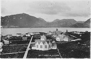
| Serves | Metlakatla, Alaska | ||||||||||||||
| Location | Annette Island | ||||||||||||||
| Built | 1941 | ||||||||||||||
| Elevation AMSL | 119 ft / 36 m | ||||||||||||||
| Coordinates | 55°02′33″N131°34′20″W / 55.04250°N 131.57222°W Coordinates: 55°02′33″N131°34′20″W / 55.04250°N 131.57222°W | ||||||||||||||
| Map | |||||||||||||||
 Annette Island AAF Location of airport in Alaska | |||||||||||||||
| Runways | |||||||||||||||
| |||||||||||||||
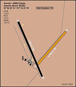
Annette Island Army Airfield is a closed United States Army airfield located on Annette Island in the Prince of Wales – Hyder Census Area of the U.S. state of Alaska. It is located 5 nautical mile s (9 km ) south of Metlakatla, Alaska. [1] After its closure, it was redeveloped into Annette Island Airport.

The United States Army (USA) is the land warfare service branch of the United States Armed Forces. It is one of the seven uniformed services of the United States, and is designated as the Army of the United States in the United States Constitution. As the oldest and most senior branch of the U.S. military in order of precedence, the modern U.S. Army has its roots in the Continental Army, which was formed to fight the American Revolutionary War (1775–1783)—before the United States of America was established as a country. After the Revolutionary War, the Congress of the Confederation created the United States Army on 3 June 1784 to replace the disbanded Continental Army. The United States Army considers itself descended from the Continental Army, and dates its institutional inception from the origin of that armed force in 1775.

Annette Island or Taak'w Aan (Tlingit) is an island in the Gravina Islands of the Alexander Archipelago of the Pacific Ocean on the southeastern coast of the U.S. state of Alaska. It is at 55°08′06″N131°27′21″W. It is about 18 km (11 mi) long and about 18 km (11 mi) wide. The land area is 332.573 km2 (128.407 sq mi). Annette Island is located west across the Revillagigedo Channel from the Alaska mainland and south of Revillagigedo Island. The Island was named in 1879 by William Healey Dall, an American naturalist and explorer in Alaska, in honor of his wife Annette Whitney Dall.

In the United States, a state is a constituent political entity, of which there are currently 50. Bound together in a political union, each state holds governmental jurisdiction over a separate and defined geographic territory and shares its sovereignty with the federal government. Due to this shared sovereignty, Americans are citizens both of the federal republic and of the state in which they reside. State citizenship and residency are flexible, and no government approval is required to move between states, except for persons restricted by certain types of court orders. Four states use the term commonwealth rather than state in their full official names.