Annette Island

Last updated
Annette Island location in southeast Alaska AKMap-doton-Metlakatla.PNG
Annette Island location in southeast Alaska
Annette Island Panorama Annette Island panorama.JPG
Annette Island Panorama

Annette Island or Taak'w Aan (Tlingit) is an island in the Gravina Islands of the Alexander Archipelago of the Pacific Ocean on the southeastern coast of the U.S. state of Alaska. It is at 55°08′06″N131°27′21″W / 55.13500°N 131.45583°W / 55.13500; -131.45583 . It is about 18 km (11 mi) long and about 18 km (11 mi) wide. The land area is 332.573 km2 (128.407 sq mi). Annette Island is located west across the Revillagigedo Channel from the Alaska mainland and south of Revillagigedo Island. The Island was named in 1879 by William Healey Dall, an American naturalist and explorer in Alaska, in honor of his wife Annette Whitney Dall. [1]

Contents

The meaning of the Tlingit name for the island is Winter Town. Since the late 19th century, it has been the base of the Annette Island Reserve of the Metlakatla Alaska Native Community, composed mostly of Tsimshian people. This is the only Indian reservation in Alaska as Metlakatla voted to opt out of giving up their lands under the Alaska Native Claims Settlement Act of the 1970s. In 2016 they elected Audrey Hudson as their first Tribal Chairwoman. [2]

Community and demographics

The largest settlement on the island is Metlakatla. The federally recognized Metlakatla Indian Community was founded by an unordained Anglican missionary William Duncan and Tsimshian followers who moved with him from their community of Metlakatla in British Columbia after he developed new doctrine and schismatized from his church.

Fish trap on Tamgas Stream, Annette Island, July 1910 Fish trap in Tamgas Stream, Annette Island, Alaska, July 26, 1910 (COBB 156).jpeg
Fish trap on Tamgas Stream, Annette Island, July 1910

Since the late 19th century, the entire island has been an Indian reserve, a status enacted by Congress when the Tlingit agreed to let the Tsimshian use this territory.

Government

The Tsimshian set up their government under the Indian Reorganization Act (1934), writing a constitution for electoral government. They have a twelve-person Council. "The mayor, secretary, and treasurer are elected by the general voting membership of the community. Each of these is elected for a two-year term. Council seats are staggered, resulting in the election of six Council seats each year and three executives every second year." [2]

Since the late 1970s, this has been the only remaining reservation in Alaska, as the Metlakatla opted out of giving up their lands for payment under the Alaska Native Claims Settlement Act. [2]

In 2016 its Tribal Chairwoman is Audrey Hudson, the first woman to be elected to this role. She also serves as mayor, city manager, and police commissioner of the Metlakatla Indian Community. [2]

The island's population was 1,447 at the 2000 census. [3] The island population is composed mainly of Tsimshian people. It is a cultural crossroads for Tlingit and Haida Natives as well.

Infrastructure

Annette Island Airfield, 1941 Landing Fields - Alaska - Annette - NARA - 68158692 (cropped).jpg
Annette Island Airfield, 1941

A network of unimproved roads and trails on the island were developed during years of logging. More than 50 years after the United States made a treaty with the Metlakatla Community that promised a cross-island road in exchange for their allowing construction and operation of an airfield on the island, it made good on its word. A joint armed forces task force constructed a 15-mile road across the island, completed from 1997 to 2007, which connected Metlakatla on the ocean side to the side facing Ketchikan, where a ferry landing has been built. [4] This has not improved access by ferry to the mainland.

After the Second World War, the airfield was used as a United States Coast Guard Search and Rescue base. It served commercial aircraft as well until the 1970s, when the new Ketchikan Airport was built at Gravina Island in the Inside Passage.

Climate

Annette Island landscape AnnetteIslandScenery.jpg
Annette Island landscape

The lower elevations of Annette Island have a Marine west coast climate (Köppen Cfb), with windy and wet weather year-round, cool winters, and mild summers, and straddle the border between USDA Plant Hardiness Zones 7 and 8. [5] Due to its southerly and maritime location, with an annual mean temperature of 47.7 °F (8.7 °C), the Annette Island Airport is one of the warmest locations statewide. Precipitation falls on most days during the winter, and the seasonal total snowfall of 33.5 inches (85 cm) occurs mostly from November to March, with some accumulation during April. Snowfall in May and October is relatively rare; warm spells raise the high to 50 °F (10 °C) for several days each month. During summer, there is an average of 17 days with 70 °F (21 °C)+ highs, and rain still falls on around half of the days. Precipitation averages more than 103 inches (2.62 m) annually, with June and July being the driest months and October and November the wettest. Extreme temperatures have ranged from −4 °F (−20 °C) on January 30, 1947, up to 93 °F (34 °C) on June 19, 2004, with the temperature having fallen below 0 °F (−18 °C) only on a handful of occasions. In addition, the Annette Island Airport holds the Alaska state monthly record high temperatures for January (66 °F or 19 °C on January 14, 2017), April (82 °F or 28 °C on April 29, 1976), and November (67 °F or 19 °C on November 1, 1970). [6]

Climate data for Annette Island Airport, Alaska, 1991–2020 normals, extremes 1941–2019 [7]
MonthJanFebMarAprMayJunJulAugSepOctNovDecYear
Record high °F (°C)66
(19)
65
(18)
65
(18)
82
(28)
88
(31)
93
(34)
90
(32)
90
(32)
82
(28)
71
(22)
67
(19)
62
(17)
93
(34)
Mean maximum °F (°C)51.6
(10.9)
51.9
(11.1)
53.5
(11.9)
64.0
(17.8)
71.2
(21.8)
77.5
(25.3)
77.8
(25.4)
78.3
(25.7)
69.2
(20.7)
60.2
(15.7)
53.3
(11.8)
50.7
(10.4)
82.0
(27.8)
Mean daily maximum °F (°C)42.9
(6.1)
44.1
(6.7)
46.0
(7.8)
51.8
(11.0)
58.6
(14.8)
62.9
(17.2)
65.9
(18.8)
66.3
(19.1)
61.1
(16.2)
53.6
(12.0)
46.8
(8.2)
43.1
(6.2)
53.6
(12.0)
Daily mean °F (°C)37.7
(3.2)
38.3
(3.5)
40.1
(4.5)
45.4
(7.4)
51.7
(10.9)
56.4
(13.6)
59.7
(15.4)
60.0
(15.6)
55.1
(12.8)
47.9
(8.8)
41.7
(5.4)
38.3
(3.5)
47.7
(8.7)
Mean daily minimum °F (°C)32.5
(0.3)
32.6
(0.3)
34.1
(1.2)
38.9
(3.8)
44.8
(7.1)
49.9
(9.9)
53.5
(11.9)
53.8
(12.1)
49.1
(9.5)
42.3
(5.7)
36.5
(2.5)
33.5
(0.8)
41.8
(5.4)
Mean minimum °F (°C)16.8
(−8.4)
19.9
(−6.7)
24.1
(−4.4)
30.7
(−0.7)
36.3
(2.4)
43.2
(6.2)
47.7
(8.7)
46.9
(8.3)
39.3
(4.1)
30.8
(−0.7)
23.2
(−4.9)
18.4
(−7.6)
10.0
(−12.2)
Record low °F (°C)−4
(−20)
2
(−17)
1
(−17)
21
(−6)
30
(−1)
37
(3)
40
(4)
40
(4)
30
(−1)
18
(−8)
−3
(−19)
1
(−17)
−4
(−20)
Average precipitation inches (mm)10.43
(265)
7.71
(196)
7.88
(200)
7.18
(182)
5.55
(141)
5.09
(129)
5.17
(131)
7.92
(201)
10.16
(258)
12.87
(327)
12.55
(319)
11.00
(279)
103.51
(2,628)
Average snowfall inches (cm)7.0
(18)
7.3
(19)
7.8
(20)
1.0
(2.5)
0.0
(0.0)
0.0
(0.0)
0.0
(0.0)
0.0
(0.0)
0.0
(0.0)
0.0
(0.0)
3.6
(9.1)
8.1
(21)
34.8
(89.6)
Average precipitation days (≥ 0.01 in)21.917.922.019.115.315.515.415.819.522.523.323.2231.4
Average snowy days (≥ 0.1 in)4.74.25.41.40.10.00.00.00.00.02.94.923.6
Average relative humidity (%)77.178.175.475.474.977.078.680.881.681.579.178.878.2
Average dew point °F (°C)27.0
(−2.8)
30.6
(−0.8)
30.6
(−0.8)
34.3
(1.3)
39.7
(4.3)
45.7
(7.6)
50.2
(10.1)
51.3
(10.7)
47.7
(8.7)
40.8
(4.9)
33.3
(0.7)
29.1
(−1.6)
38.4
(3.5)
Mean monthly sunshine hours 49.670.6105.4147.0186.0162.0148.8145.7108.068.251.034.11,276.4
Mean daily sunshine hours 1.62.53.44.96.05.44.84.73.62.21.71.13.5
Source 1: NOAA (humidity and dew point 1961–1990, mean maxima/minima 19812010) [8] [9] [10]
Source 2: Deutscher Wetterdienst (sun 1961–1990) [11]

Demographics

Historical population
CensusPop.Note
1950 302
1960 33711.6%
1970 195−42.1%
1980 139−28.7%
1990 43−69.1%
U.S. Decennial Census [12]

Annette first appeared on the 1950 U.S. Census as an unincorporated village. [13] In 1980, it was made a census-designated place (CDP). [14] It last returned in 1990 [15] and was dissolved as a CDP effective as of the 2000 census. [16]

Related Research Articles

<span class="mw-page-title-main">Southeast Alaska</span> Region of Alaska

Southeast Alaska, often abbreviated to Southeast or Southeastern, and sometimes called the Alaska(n) Panhandle, is the southeastern portion of the U.S. state of Alaska, bordered to the east and north by the northern half of the Canadian province of British Columbia. The majority of Southeast Alaska is situated in Tlingit Aaní, much of which is part of the Tongass National Forest, the United States' largest national forest. In many places, the international border runs along the crest of the Boundary Ranges of the Coast Mountains. The region is noted for its scenery and mild, rainy climate.

<span class="mw-page-title-main">Prince of Wales–Hyder Census Area, Alaska</span> Census area in Alaska, United States

Prince of Wales–Hyder Census Area is a census area located in the U.S. state of Alaska. As of the 2020 census, the population was 5,753, up from 5,559 in 2010. It is part of the unorganized borough and therefore has no borough seat. Its largest communities are Metlakatla and Craig. It was formerly part of the Census Bureau's Prince of Wales–Outer Ketchikan Census Area, but the name was changed in 2008 after most of the Outer Ketchikan was lost to annexation by the Ketchikan Gateway Borough.

<span class="mw-page-title-main">Yakutat, Alaska</span> Consolidated city-borough in Alaska, United States

The City and Borough of Yakutat is a borough in the state of Alaska. Yakutat was also the name of a former city within the borough. The name in Tlingit is Yaakwdáat. It is derived from an Eyak name, diyaʼqudaʼt, and was influenced by the Tlingit word yaakw.

<span class="mw-page-title-main">Ketchikan, Alaska</span> City in Alaska, United States

Ketchikan is a city in and the borough seat of the Ketchikan Gateway Borough of Alaska. It is the state's southeasternmost major settlement. Downtown Ketchikan is a National Historic Landmark District.

<span class="mw-page-title-main">Metlakatla, Alaska</span> CDP in Alaska, United States

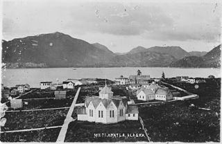
Metlakatla is a census-designated place (CDP) on Annette Island in Prince of Wales-Hyder Census Area, Alaska, United States. At the 2010 census the population was 1,405; this had grown to 1,454 by the 2020 census.

<span class="mw-page-title-main">Angoon, Alaska</span> City in Alaska, United States

Angoon is a city on Admiralty Island in Hoonah-Angoon Census Area, Alaska, United States. At the 2000 census the population was 572; by the 2010 census the population had declined to 459. The name in Tlingit, Aangóon, means roughly "isthmus town."

<span class="mw-page-title-main">Tsimshian</span> Indigenous people of the northwest coast of North America

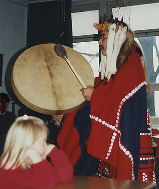
The Tsimshian are an Indigenous people of the Pacific Northwest Coast of North America. Their communities are mostly in coastal British Columbia in Terrace and Prince Rupert, and Metlakatla, Alaska on Annette Island, the only reservation in Alaska.

<span class="mw-page-title-main">Alexander Archipelago</span> Island group off the southeastern coast of Alaska, United States

The Alexander Archipelago is a 300-mile (480 km) long archipelago in North America lying off the southeastern coast of Alaska. It contains about 1,100 islands, the tops of submerged coastal mountains that rise steeply from the Pacific Ocean. Deep channels and fjords separate the islands and cut them off from the mainland. The islands shelter the northern part of the Inside Passage as it winds its way among them.

Revillagigedo Island is an island in the Alexander Archipelago in Ketchikan Gateway Borough of the southeastern region of the U.S. state of Alaska. Running about 89 km (50 mi) north-south and 48 km (35 mi) east-west, it is 2,754.835 km² (1,063.65 mi²) in area, making it the 12th largest island in the United States and the 170th largest island in the world. Its center is located near 55°38′03″N131°17′51″W.

<span class="mw-page-title-main">Gravina Island</span> Island in Alexander Archipelago, Alaska, US

Gravina Island is an island in the Gravina Islands of the Alexander Archipelago in southeastern Alaska. It is 21 miles (34 km) long and about 9.5 miles (15.3 km) wide, with a land area of 94.81 square miles (245.6 km2). The island had a population of 50 people at the 2000 census.

<span class="mw-page-title-main">Tsimshianic languages</span> Endangered language family of British Columbia and Alaska

The Tsimshianic languages are a family of languages spoken in northwestern British Columbia and in Southeast Alaska on Annette Island and Ketchikan. All Tsimshianic languages are endangered, some with only around 400 speakers. Only around 2,170 people of the ethnic Tsimshian population in Canada still speak a Tsimshian language; about 50 of the 1,300 Tsimshian people living in Alaska still speak Coast Tsimshian. Tsimshianic languages are considered by most linguists to be an independent language family, with four main languages: Coast Tsimshian, Southern Tsimshian, Nisg̱a’a, and Gitksan.

<span class="mw-page-title-main">Ketchikan International Airport</span> Airport

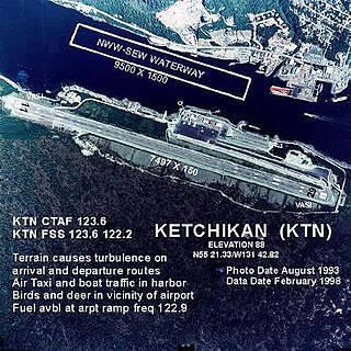
Ketchikan International Airport is a state-owned, public-use airport located one nautical mile (2 km) west of the central business district of Ketchikan, a city in Ketchikan Gateway Borough in Alaska, that has no direct road access to the outside world or to the airport. The airport is located on Gravina Island, just west of Ketchikan on the other side of the Tongass Narrows. Passengers must take a seven-minute ferry ride across the water to get to the airport from the town.

MV <i>Lituya</i>

MV Lituya is a shuttle ferry operated by the Alaska Marine Highway System. Her route connects Metlakatla on Annette Island to Ketchikan.

<span class="mw-page-title-main">Peter Simpson (Native rights activist)</span>

Peter Simpson (1871?–1947) was a Canadian-born Tsimshian activist for Alaska Native rights, and co-owner of the first Indian-owned business in Alaska.

<span class="mw-page-title-main">William Duncan (missionary)</span> English missionary

William Duncan was an English-born Anglican missionary who founded the Tsimshian communities of Metlakatla, British Columbia, in Canada, and Metlakatla, Alaska, in the United States. Although sometimes referred to as "Father Duncan" in subsequent reports, he was never ordained.

<span class="mw-page-title-main">Edward Marsden</span> Canadian-American missionary

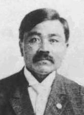
The Rev. Edward Marsden (1869–1932) was a Canadian-American missionary and member of the Tsimshian nation who became the first Alaska Native to be ordained in the ministry.

<span class="mw-page-title-main">David A. Boxley</span> American artist

David A. Boxley is an American artist from the Tsimshian tribe in Alaska, most known for his prolific creation of Totem Poles and other Tsimshian artworks.

<span class="mw-page-title-main">Benjamin Haldane</span> First Nations photographer

Benjamin Alfred Haldane was a Tsimshian professional photographer from Metlakatla, Alaska.

<span class="mw-page-title-main">Loring, Alaska</span> Unincorporated community in Alaska, United States

Loring was established in 1885 with the first post office in the District of Alaska and is a census-designated place (CDP) in Ketchikan Gateway Borough in the U.S. state of Alaska. As of the 2020 census, The population is 0, down from 4 at the 2010 census, although the number increases in summer months.

<span class="mw-page-title-main">Pennock Island</span>

Pennock Island is located in the U.S. state of Alaska near the city of Ketchikan. The island is situated within the Ketchikan Gateway Borough and is part of the Alexander Archipelago. Most of the island is public land managed by the Tongass National Forest.

References

  1. Fuller, Myron F.; Sanford, Samuel (1906). Record of Deep-Well Drilling for 1905. Washington: Government Printing Office. p. 102. Retrieved 17 April 2015.
  2. 1 2 3 4 Dennis Zotigh, "Audrey Hudson: NMAI’s Meet Native America Series" Archived 2016-06-28 at the Wayback Machine , Indian Country Today, 26 June 2016; accessed 27 June 2016
  3. Annette Island: Block Groups 1 and 2 and Blocks 3004 thru 3013, Block Group 3, Census Tract 4, Prince of Wales-Outer Ketchikan Census Area, Alaska United States Census Bureau
  4. Fact Sheet: "Operation Alaskan Road: Joint Task Force Alaskan Road," Elmendorf Air Force Base; Retrieved on February 6, 2008.
  5. "USDA Plant Hardiness Zone Map zip code 99926". USDA. Archived from the original on 2021-08-16. Retrieved 15 August 2021.
  6. All-time Statewide Daily Temperature Extremes Archived 2010-06-10 at the Wayback Machine
  7. "Service Change Notice 19-75" (PDF). National Weather Service. 2019-09-03. Archived from the original (PDF) on 2020-10-16. Retrieved 2019-09-03.
  8. "NOWData NOAA Online Weather Data". National Oceanic and Atmospheric Administration . Retrieved 2022-09-01.
  9. "Station Name: AK ANNETTE ISLAND AP". National Oceanic and Atmospheric Administration. Retrieved 2019-10-31.
  10. "U.S. Climate Normals Quick Access". National Oceanic and Atmospheric Administration . Retrieved August 24, 2022.
  11. "Klimatafel von Annette / Annette Island, Alaska / USA" (PDF). Baseline climate means (1961-1990) from stations all over the world (in German). Deutscher Wetterdienst. Archived from the original (PDF) on 2023-07-15. Retrieved November 28, 2016.
  12. "U.S. Decennial Census". Census.gov. Retrieved June 6, 2013.
  13. "Number of Inhabitants: Alaska" (PDF). census.gov. 1950. Archived (PDF) from the original on 2010-08-10.
  14. "Number of Inhabitants: Alaska" (PDF). census.gov. 1980. Archived (PDF) from the original on 2010-08-05.
  15. "1990 Census of Population and Housing, Summary Social, Economic, and Housing Characteristics: Alaska" (PDF). census.gov. 1990. Archived (PDF) from the original on 2004-07-21.
  16. "2000 Census of Population and Housing, Summary Population and Housing Characteristics: Alaska" (PDF). census.gov. 2000. Archived (PDF) from the original on 2003-03-21.