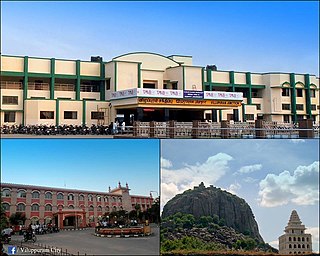
Viluppuram is one of the 33 districts which make up the state of Tamil Nadu, situated on the southern tip of India. The district headquarters is located at Viluppuram. The district was founded on September 30, 1993, when it was created out of the South Arcot district. Viluppuram is the largest district in the state. It lies between the Tiruchirapalli and Chennai national highways. It is well-connected by rail and road, and is a major rail junction. This district has several tourist spots which are more than 500 years old, such as the Gingee Fort.

Brammadesam is an Indian Panchayat village located in Tindivanam taluk of Villupuram district in the state of Tamil Nadu. It is one of the 56 village panchayats coming under Marakkanam block of the Villupuram district. The village code for Brahmadesam is 10 and it falls under the Marakkanam Block.
Koonimedu is a panchayat village in Tamil Nadu, India. It is part of the Marakkanam block of the Viluppuram district and is located 22 kilometres from Pondicherry and 130 km (81 mi) from Chennai. It has a population of approximately 5000 people, of whom 70% are Muslims and the remaining 30% predominantly non Muslims.Koonimedu is also known as chinna kuwait because of their occupational route. One after another, koonimedu people travelleing Kuwait to earn. Apart from Kuwait, some other countries where Koonimedu NRIs living is Singapore, Malaysia, UAE, Oman, Qatar, France and Saudi Arabia. Koonimedu village was one of the oldest villages in Villupuram. It is said that, muslim population spread here during period King Arcod Nawab, for his soldiers passing way to Pondicherry old French colony. The latitude 12.11574 and longitude 79.907041 are the geocoordinate of the Koonimedu. Chennai is the state capital for Koonimedu village. It is located around 116.5 km (72.4 mi) away from Koonimedu.. The other nearest state capital from Koonimedu is Pondicherry and its distance is 21.3 km The other surrounding state capitals are Pondicherry 21.3 km, Bangalore 271.3 km, Thiruvananthapuram 506.5 km (314.7 mi)
The Chinnasalem block is a revenue block in the Viluppuram district of Tamil Nadu, India. It has a total of 50 panchayat villages.
The Kanai block is a revenue block in the Viluppuram district of Tamil Nadu, India. It has a total of 51 panchayat villages.
The Marakkanam block is a revenue block in the Viluppuram district of Tamil Nadu, India. It has a total of 56 panchayat villages.
The Mugaiyur block is a revenue block in the Viluppuram district of Tamil Nadu, India. It has a total of 63 panchayat villages.
The Rishivandiyam block is a revenue block in the Viluppuram district of Tamil Nadu, India. It has a total of 53 panchayat villages.
The Gingee block is a revenue block in the Viluppuram district of Tamil Nadu, India. It has a total of 60 panchayat villages.
The Kandamangalam block is a revenue block in the Viluppuram district of Tamil Nadu, India. It has a total of 45 panchayat villages.
The Mailam block is a revenue block in the Viluppuram district of Tamil Nadu, India. It has a total of 47 panchayat villages.
The Melmalayanur block is a revenue block in the Viluppuram district of Tamil Nadu, India. It has a total of 55 panchayat villages.
The Kallakkurichi block is a revenue block in the Viluppuram district of Tamil Nadu, India. It has a total of 46 panchayat villages.
The Gingee block is a revenue block in the Viluppuram district of Tamil Nadu, India. It has a total of 15 panchayat villages.
The Thiruvennainallur block is a revenue block in the Viluppuram district of Tamil Nadu, India. It has a total of 49 panchayat villages.
The Sankarapuram is a revenue block in the Viluppuram district of Tamil Nadu, India. It has a total of 44 panchayat villages.
The Tirunavalur block is a revenue block in the Viluppuram district of Tamil Nadu, India. It has a total of 44 panchayat villages.
Annamputhur is a village panchayat in the Marakkanam block, Viluppuram district, Tamil Nadu, India. The panchayat is known for Srinidheeswarar temple and a huge Shivalinga that people of this area have had reconstructed with the help of the Archaeological Survey of India.

Endiyur is a village panchayat located in Tindivanam Taluk Villupuram district of Tamil-Nadu State, India. Pin code of Endiyur is 604 001 and telephone STD code is 04147. Native language of the village is Tamil. The village is connected with nearby places through road transport SH-134. Nearest railway station is Tindivanam which is 5 km from the village. Puducherry is 32.8 km from Endiyur. The village has a grand Draupadi Amman temple in the center of the village and the villagers celebrate 7 to 10 days of temple festival in the month of May or June every year including theemidhi thiruvizha. Endiyur Boys, a group consisting of youngsters from the village are working towards publishing the goodness of their village online.


