Aokautere is named after Te Aokautere, a great Rangitāne chief during the late 18th century. In the 19th century, it was known as Fitzherbert, after the politician William Fitzherbert who promoted settlement of the Manawatu. The Fitzherbert East Dairy Factory building still carries the name these days.[2]
Aokautere has views of the Ruahine and Tararua Ranges (with the Wind Turbine Farms) and on a clear day it is possible to see Ruapehu.
Anzac Park (Te Motu-o-Poutoa), a clifftop reserve colloquially known as Pork Chop Hill, has views across the city, through to the southern Ruahine and northern Tararua ranges. It is also possible to see distant Taranaki and Ruapehu. There is also access to the Stairway of Tāne (Te Arapiki-a-Tāne), steps cut into the former Anzac Cliffs, now collapsed into a slope.
Prior to 1996, Aokautere was part of the Manawatu electorate. However, due to the reformation of the electoral system from FPP to MMP, the electorate of Palmerston North's boundaries were redrawn to include Aokautere. Palmerston North's electorate boundaries were redrawn in 2007 and Aokautere was shifted to the Rangitikei electorate. Rangitikei as of 2020 is represented by National MP Ian McKelvie, who was elected in 2011.
The Aokautere statistical area, which covers 7.14km2 (2.76sqmi),[3] had a population of 765 at the 2018 New Zealand census, an increase of 99 people (14.9%) since the 2013 census, and an increase of 198 people (34.9%) since the 2006 census. There were 237 households. There were 384 males and 384 females, giving a sex ratio of 1.0 males per female. The median age was 40.6 years (compared with 37.4 years nationally), with 186 people (24.3%) aged under 15 years, 123 (16.1%) aged 15 to 29, 354 (46.3%) aged 30 to 64, and 102 (13.3%) aged 65 or older.
Ethnicities were 88.6% European/Pākehā, 8.6% Māori, 1.6% Pacific peoples, 5.1% Asian, and 3.1% other ethnicities (totals add to more than 100% since people could identify with multiple ethnicities).
The proportion of people born overseas was 24.7%, compared with 27.1% nationally.
Although some people objected to giving their religion, 52.9% had no religion, 38.8% were Christian, 1.2% were Hindu, 0.4% were Buddhist and 1.6% had other religions.
Of those at least 15 years old, 222 (38.3%) people had a bachelor or higher degree, and 51 (8.8%) people had no formal qualifications. The median income was $43,100, compared with $31,800 nationally. The employment status of those at least 15 was that 273 (47.2%) people were employed full-time, 132 (22.8%) were part-time, and 18 (3.1%) were unemployed.[1]
Aokautere Rural is a statistical area east and southeast of Aokautere, which covers 83.31km2 (32.17sqmi).[5] It had a population of 690 at the 2018 New Zealand census, an increase of 45 people (7.0%) since the 2013 census, and an increase of 153 people (28.5%) since the 2006 census. There were 243 households. There were 336 males and 351 females, giving a sex ratio of 0.96 males per female. The median age was 43.4 years (compared with 37.4 years nationally), with 144 people (20.9%) aged under 15 years, 108 (15.7%) aged 15 to 29, 354 (51.3%) aged 30 to 64, and 84 (12.2%) aged 65 or older.
Ethnicities were 91.3% European/Pākehā, 8.3% Māori, 0.9% Pacific peoples, 3.5% Asian, and 3.9% other ethnicities (totals add to more than 100% since people could identify with multiple ethnicities).
The proportion of people born overseas was 18.7%, compared with 27.1% nationally.
Although some people objected to giving their religion, 56.1% had no religion, 34.3% were Christian, 0.9% were Muslim, 0.4% were Buddhist and 0.9% had other religions.
Of those at least 15 years old, 189 (34.6%) people had a bachelor or higher degree, and 54 (9.9%) people had no formal qualifications. The median income was $46,400, compared with $31,800 nationally. The employment status of those at least 15 was that 327 (59.9%) people were employed full-time, 99 (18.1%) were part-time, and 15 (2.7%) were unemployed.[4]
Education
Aokautere School is a co-educational state primary school for Year 1 to 6 students,[6] with a roll of 134 as of March 2021.[7]
Palmerston North is a city in the North Island of New Zealand and the seat of the Manawatū-Whanganui region. Located in the eastern Manawatu Plains, the city is near the north bank of the Manawatu River, 35 km (22 mi) from the river's mouth, and 12 km (7 mi) from the end of the Manawatu Gorge, about 140 km (87 mi) north of the capital, Wellington. Palmerston North is the country's eighth-largest urban area, with an urban population of 81,500.
Manawatū-Whanganui is a region in the lower half of the North Island of New Zealand, whose main population centres are the cities of Palmerston North and Whanganui. It is administered by the Manawatū-Whanganui Regional Council, which operates under the name Horizons Regional Council.
Bulls is a small town north west of Palmerston North on the west coast of the North Island of New Zealand. It is in a fertile farming area in the Rangitikei District at the junction of State Highways 1 and 3 about 135 kilometres (84 mi) north of Wellington. According to a June 2020 Statistics New Zealand estimate, Bulls has a population of 2,150 inhabitants.
The Tararua District is an area near the south-east corner of New Zealand's North Island that is administered by the Tararua District Council. It has a population of 18,900, and an area of 4,360.56 km². The Tararua District Council was created by the amalgamation of the Dannevirke Borough, Eketahuna County Council, Pahiatua Borough Council, Pahiatua County Council and Woodville District Council in the 1989 local government reforms.
The Manawatu District is a local government district in the Manawatū-Whanganui Region in the North Island of New Zealand.
Woodville, previously known as The Junction is a small town in the southern North Island of New Zealand, 75 km north of Masterton and 25 km east of Palmerston North. The 2013 census showed that 1401 people reside in Woodville.
Ashhurst is a township and outlying suburb of Palmerston North, in the Manawatū-Whanganui region of New Zealand's North Island.
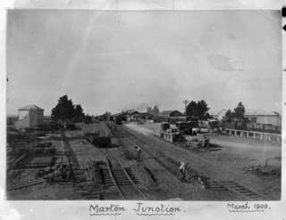
Marton is a town in the Rangitikei district of the Manawatū-Whanganui region of New Zealand's North Island. It is situated 35 kilometres southeast of Whanganui and 40 kilometres northwest of Palmerston North.
The Rangitikei District is a territorial authority located primarily in the Manawatū-Whanganui region in the North Island of New Zealand, although a small part, the town of Ngamatea, lies in the Hawke's Bay Region. It is located in the southwest of the island, and follows the catchment area of the Rangitīkei River.
Linton is a suburb of Palmerston North, situated 11km south-west of the city.
Roslyn is a suburb in the city of Palmerston North, Manawatū-Whanganui, New Zealand.
Kelvin Grove is a suburb of Palmerston North on New Zealand's North Island. It is bounded on the north by the North Island Main Trunk railway, Manawatu District and Milson, on the west by Palmerston North–Gisborne Line and Roslyn, the south by the Manawatu River, and the east by James Line and Whakarongo.
Hokowhitu is a riverside suburb of the New Zealand city of Palmerston North, with some of the highest property values in the city.
Fitzherbert is a suburb of Palmerston North, Manawatū-Whanganui, New Zealand.
Milson is a suburb of Palmerston North, Manawatū-Whanganui, New Zealand. The suburb is located to the north of the city, beyond the North Island Main Trunk Rail.
Palmerston North Central is the central suburb and central business district of Palmerston North, on New Zealand's North Island.
Pohangina is a small rural community in the Manawatū-Whanganui region of New Zealand, just north of Ashhurst.
Porewa is a rural community, in the Rangitikei District of the Manawatū-Whanganui region of New Zealand's North Island.
Kauwhata is a rural locality and a statistical area in Manawatu District, in the Manawatū-Whanganui region in New Zealand's central North Island.
Parewanui is a settlement situated southeast of Bulls in the North Island of New Zealand.
This page is based on this Wikipedia article Text is available under the CC BY-SA 4.0 license; additional terms may apply. Images, videos and audio are available under their respective licenses.