The Palmerston North Teachers' College was built in Hokowhitu in the 1960s. Massey University took over the college in 2009. The New Zealand Defence Force began using some of the buildings in 2011.[3]
Massey relocated the college to Turitea campus in 2013 and sold the land in 2016. When the site was sold, the land consisted of 20 buildings; including halls, offices, a library, a marae and sporting facilities.[4] The site began to be redeveloped into housing in 2018.[5]
The Hokowhitu Lagoon, Caccia Birch House, Jickell Street Reserve and Manawatu Golf Course are located next to the former education campus. Wallace Park, the home of the Ruahine Association Football Club and local cricket teams, is located nearby. Other local features include the Hokowhitu Domain, Crewe Crescent Reserve, Franklin Reserve, Fitzroy Bend Park, Milverton Park and playground, Awatea Reserve and stream, Hardie St Park and Centennial Drive Reserve.[6]
Hokowhitu is part of the Palmerston North and Te Tai Hauāuru electorates.
Hokowhitu covers 5.19km2 (2.00sqmi)[1] and had an estimated population of 11,460 as of June 2022,[2] with a population density of 2,208 people per km2.
Hokowhitu had a population of 10,950 at the 2018 New Zealand census, an increase of 315 people (3.0%) since the 2013 census, and an increase of 399 people (3.8%) since the 2006 census. There were 4,113 households, comprising 5,232 males and 5,712 females, giving a sex ratio of 0.92 males per female, with 1,830 people (16.7%) aged under 15 years, 2,838 (25.9%) aged 15 to 29, 4,557 (41.6%) aged 30 to 64, and 1,725 (15.8%) aged 65 or older.
Ethnicities were 77.5% European/Pākehā, 11.8% Māori, 3.0% Pacific peoples, 15.3% Asian, and 3.3% other ethnicities. People may identify with more than one ethnicity.
The percentage of people born overseas was 26.7, compared with 27.1% nationally.
Although some people chose not to answer the census's question about religious affiliation, 47.8% had no religion, 38.5% were Christian, 0.6% had Māori religious beliefs, 1.9% were Hindu, 1.4% were Muslim, 1.7% were Buddhist and 1.9% had other religions.
Of those at least 15 years old, 3,138 (34.4%) people had a bachelor's or higher degree, and 942 (10.3%) people had no formal qualifications. 1,920 people (21.1%) earned over $70,000 compared to 17.2% nationally. The employment status of those at least 15 was that 4,197 (46.0%) people were employed full-time, 1,521 (16.7%) were part-time, and 399 (4.4%) were unemployed.[7]
Hokowhitu has three co-educational state primary schools: Hokowhitu School in the north,[13][14] with a roll of 361,[15] College Street Normal School in the west,[16][17] with a roll of 599,[18] and Winchester School in the east,[19][20] with a roll of 358.[21]
St James School, a co-educational state-integrated Catholic primary school located just south of Hokowhitu School,[22][23] has a roll of 145.[24]
Dannevirke, is a rural service town in the Manawatū-Whanganui region of the North Island, New Zealand. It is the major town of the administrative of the Tararua District, the easternmost of the districts of which the Horizons Regional Council has responsibilities.
Ashhurst is a town and outlying suburb of Palmerston North, in the Manawatū-Whanganui region of New Zealand's North Island.
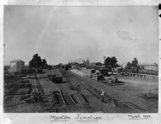
Marton is a town in the Rangitikei district of the Manawatū-Whanganui region of New Zealand's North Island. It is situated 35 kilometres southeast of Whanganui and 40 kilometres northwest of Palmerston North.
Roslyn is a suburb in the city of Palmerston North, Manawatū-Whanganui, New Zealand.
Kelvin Grove is a suburb of Palmerston North on New Zealand's North Island. It is bounded on the north by the North Island Main Trunk railway, Manawatū District and Milson, on the west by Palmerston North–Gisborne Line and Roslyn, the south by the Manawatū River, and the east by James Line and Whakarongo.
Papaioea is a suburb of Palmerston North on New Zealand's North Island.
Aokautere is a suburb of the New Zealand city of Palmerston North. It is situated in the cliffs on the south banks of the Manawatu River.
Terrace End is a suburb of Palmerston North, New Zealand.
Milson is a suburb of Palmerston North, Manawatū-Whanganui, New Zealand. The suburb is located to the north of the city, beyond the North Island Main Trunk Rail.
Takaro is a suburb and constituent ward of Palmerston North, Manawatū-Whanganui, New Zealand.
Awapuni is a suburb of Palmerston North, Manawatū-Whanganui, New Zealand. It is located south west of Palmerston North Central. The New Zealand Ministry for Culture and Heritage gives a translation of "blocked-up river" for Awapuni.
West End is a suburb of the New Zealand city of Palmerston North.
Palmerston North Central is the central suburb and central business district of Palmerston North, on New Zealand's North Island.
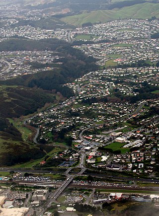
Cannons Creek is a suburb of Porirua City approximately 22km north of Wellington in New Zealand.
Te Hapara is a suburb of the New Zealand city of Gisborne. It is located in the northwest of the city. It contains one primary school, Te Hapara School, which is located in Mill Road.
Nelson South is an inner suburb of Nelson, New Zealand. It lies to the southwest of Nelson city centre, between it and Bishopdale, close to the foot of The Grampians. The main inland route to Stoke, New Zealand, Waimea Road, is Nelson South's main road.
Riverdale is a suburb of Gisborne, in the Gisborne District of New Zealand's North Island.
Whanganui East is a suburb of Whanganui, in the Whanganui District and Manawatū-Whanganui region of New Zealand's North Island.
College Estate is a suburb of Whanganui, in the Whanganui District and Manawatū-Whanganui region of New Zealand's North Island.
Manukura is a co-educational designated character school for Year 9 to 13 students. It is based at Massey University in Palmerston North, New Zealand. It is effectively a sports academy specialising in Māori students. The school was founded in 2005 and was originally known as Tū Toa. The school has programmes in netball, basketball, rugby union and rugby sevens. Yvette McCausland-Durie was a co-founder of the school, and is also a member of its board of trustees.
1 2 "Statistical area 1 dataset for 2018 Census". Statistics New Zealand. March 2020. Milverton (231400), Hokowhitu Central (231700), Hokowhitu East (231800), Ruahine (232000) and Hokowhitu South (232300).
This page is based on this Wikipedia article Text is available under the CC BY-SA 4.0 license; additional terms may apply. Images, videos and audio are available under their respective licenses.