Applegate Valley

Last updated
Image of Ruch, Oregon Ruch, Oregon.jpg
Image of Ruch, Oregon
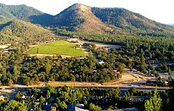
A view of Applegate Valley from Woodrat Mountain Applegate.jpg
A view of Applegate Valley from Woodrat Mountain

Applegate Valley is the valley of the Applegate River in Southern Oregon, United States and extending slightly into Northern California. Applegate Valley is in Jackson County to the east and Josephine County to the west, and includes a little bit of Siskiyou County in California near Applegate Lake. It encompasses the area between Jacksonville and Grants Pass. Oregon Route 238 (Jacksonville Highway) is a main route through the valley. The five recognized unincorporated communities in Applegate Valley are Ruch and Applegate in Jackson County, and Williams, Murphy, and Wilderville in Josephine County.

Many wineries of the Applegate Valley AVA (American Viticultural Area), a sub-appellation of the Rogue Valley AVA, are located in the valley.

The area is also a well known medical marijuana growing region.[ citation needed ]

See also

42°19′N123°17′W / 42.32°N 123.29°W / 42.32; -123.29


Related Research Articles

<span class="mw-page-title-main">Josephine County, Oregon</span> County in Oregon, United States

Josephine County is one of the 36 counties in the U.S. state of Oregon. As of the 2020 census, the population was 88,090. The county seat is Grants Pass. The county is named after Virginia Josephine Rollins (1834–1912), a settler who was the first white woman to live in the county's boundaries. Josephine County comprises the Grants Pass, OR Metropolitan Statistical Area, which is included in the Medford-Grants Pass, OR Combined Statistical Area.

<span class="mw-page-title-main">Jackson County, Oregon</span> County in Oregon, United States

Jackson County is one of the 36 counties in the U.S. state of Oregon. As of the 2020 census, the population was 223,259. The county seat is Medford. The county is named for Andrew Jackson, the seventh president of the United States. Jackson County comprises the Medford, OR Metropolitan Statistical Area. There are 11 incorporated cities and 34 unincorporated communities in Jackson County; the largest is Medford, which has been the county seat since 1927.

<span class="mw-page-title-main">Rogue Valley</span> Valley in Southern Oregon, United States

The Rogue Valley is a valley region in southwestern Oregon in the United States. Located along the middle Rogue River and its tributaries in Josephine and Jackson counties, the valley forms the cultural and economic heart of Southern Oregon near the California border. The largest communities in the Rogue Valley are Medford, Ashland and Grants Pass. The most populated part of the Rogue Valley is not along the Rogue proper, but along the smaller Bear Creek tributary.

<span class="mw-page-title-main">Applegate, Oregon</span> Unincorporated community in the state of Oregon, United States

Applegate is an unincorporated community in Jackson County, Oregon, United States. It is west of Medford on Oregon Route 238 and the Applegate River. The community was probably named for Lindsay Applegate, who, along with his brothers Jesse and Charles, explored the Applegate Valley while blazing the Applegate Trail.

<span class="mw-page-title-main">Southern Oregon AVA</span> American Viticultural Area

The Southern Oregon AVA is an American Viticultural Area which lies in Southern Oregon, United States. The Southern Oregon AVA was established in 2005 and was created to include the land of two smaller AVAs: the Rogue Valley AVA and the Umpqua Valley AVA. Southern Oregon AVA was established to allow the two principal winegrowing regions in the southern part of the state to market themselves jointly. This creation of a "super-AVA" is a departure from the trend in the Willamette Valley AVA or northern Oregon of establishing smaller AVAs specific to a particular locale's climate or soil conditions.

<span class="mw-page-title-main">Rogue Valley AVA</span> American Viticultural Area in southern Oregon

The Rogue Valley AVA is an American Viticultural Area located in southern Oregon. The federal government approved this appellation in 1991. It is entirely contained within the larger Southern Oregon AVA and includes the drainage basin of the Rogue River and several tributaries, including the Illinois River, the Applegate River, and Bear Creek. Most wineries in the region are found in the valleys formed by one of these three tributaries, rather than along the Rogue River itself. The region is 70 miles (113 km) wide by 60 miles (97 km) long ; there are fewer than 20 wineries with only 1,100 acres (450 ha) planted. Each river valley has a unique terroir, and grows different varieties of grapes. Overall, however, this region is the warmest and driest of Oregon's wine-growing regions.

<span class="mw-page-title-main">Applegate Valley AVA</span> Designated wine grape-growing region in Oregon

The Applegate Valley AVA is an American Viticultural Area located in southern Oregon. It is entirely contained within the Rogue Valley AVA, which is itself included within the larger Southern Oregon AVA. The region is named for the Applegate River, which flows through the town of Applegate and near the city of Jacksonville. The Applegate Valley has been a grape-growing region since 1870 when A. H. Carson began planting 30 acres of grapes along North Applegate Road. One of Oregon's first wineries was established in the Applegate Valley. This region contains vineyards at altitudes ranging from 1,000 feet (300 m) to 1,500 feet (500 m) above sea level, and is warmer and drier than the Illinois Valley to the west, but less so than the Bear Creek Valley to the east. Grapes that thrive here include Tempranillo, Merlot, Cabernet Franc, Cabernet Sauvignon, Syrah, Tannat, Vermentino, Chardonnay, and Zinfandel.

<span class="mw-page-title-main">Applegate River</span> River in Oregon, United States of America

The Applegate River is a 51-mile (82 km)-long tributary of the Rogue River in the U.S. state of Oregon. It drains approximately 698 square miles (1,810 km2). Rising in northern California, it soon crosses the border and flows northeast then northwest to meet the Rogue about 6 miles (9.7 km) west of Grants Pass. It drains forested foothills of the Siskiyou Mountains along the Oregon–California border.

<span class="mw-page-title-main">Ruch, Oregon</span> Unincorporated community in Oregon, US

Ruch is an unincorporated community and census-designated place (CDP) in Jackson County, Oregon, United States. It is located on Oregon Route 238, southeast of Grants Pass. As of the 2010 census, it had a population of 840.

Valley View Winery is a winery in the Applegate Valley AVA in Southern Oregon, United States, founded in 1972.

The Red Hill Douglas County, Oregon AVA is an American Viticultural Area located in Douglas County, Oregon, near the town of Yoncalla. It is entirely contained within the Umpqua Valley AVA, which is itself included within the larger Southern Oregon AVA.

<span class="mw-page-title-main">Eola-Amity Hills AVA</span>

The Eola-Amity Hills AVA is an American Viticultural Area located in Polk County and Yamhill County, Oregon. It is entirely contained within the Willamette Valley AVA, and stretches from the city of Amity in the north to Salem in the south. The Eola and Amity hills cover an area west of the Willamette River approximately 15 miles (24 km) long by 6 miles (10 km) wide. The Eola-Amity Hills area benefits from steady winds off the Pacific Ocean that reach the Willamette Valley through the Van Duzer Corridor, a gap in the Oregon Coast Range, moderating the summer temperatures. The Eola Hills were named after the community of Eola, whose name was derived from Aeolus, the Greek god of the winds.

<span class="mw-page-title-main">Williams, Oregon</span> Unincorporated community in the state of Oregon, United States

Williams is an unincorporated community and census-designated place (CDP) in Josephine County, Oregon, United States. As of the 2010 census it had a population of 1,072.

Wonder is an unincorporated community in Josephine County, Oregon, United States, on U.S. Route 199 about 13 miles west of Grants Pass and 8 miles east of Selma. It is within the Rogue River – Siskiyou National Forest.

Pleasant Valley is an unincorporated community in Josephine County, Oregon, United States. It is located about 11 miles (18 km) north of Grants Pass, just west of Interstate 5. The community, which is located along the route of the Applegate Trail, is the site of a pioneer cemetery, and at one time it had a school.

<span class="mw-page-title-main">Charles S. Drew</span> American Union Army officer (1825–1886)

Charles Stewart Drew, also known as C.S. Drew, was a representative in the legislature of the Oregon Territory of the United States and quartermaster general of the territorial militia in the 1850s. During the American Civil War, he was a Union Army officer, serving in the 1st Oregon Cavalry regiment. He eventually reached the rank of lieutenant colonel. In 1864, he led an Army reconnaissance party into southeastern Oregon. The expedition, known as the Owyhee Reconnaissance, traveled through uncharted country from Fort Klamath to Fort Boise and back. Drew was the author of two historically important military reports; one documented Indian attacks on American settlers in the Oregon Territory and the other was his report of the Owyhee Reconnaissance.

<span class="mw-page-title-main">John E. Ross</span> American politician

John England Ross was an American politician born in Madison County, Ohio. He led volunteer forces from Oregon in the Cayuse War and the Modoc War, prospected for gold in the California Gold Rush, and represented Jackson County, Oregon in the Oregon Territorial Legislature and Oregon State Senate.

<span class="mw-page-title-main">McKee Bridge</span> United States historic place

The McKee Bridge is a covered bridge in Jackson County in the U.S. state of Oregon. Built on land donated by Adelbert (Deb) McKee, a stage station operator, the bridge originally carried a road over the Applegate River that linked the Blue Ledge Copper Mine to Jacksonville. The site originally included an ore-hauler rest stop, about halfway between the mine and the city, where relief horses were stationed. The bridge, about 8.3 miles (13.4 km) north of the California border, carried mining and logging traffic from the year of its construction, 1917, through 1956. An unincorporated community, McKee Bridge, is near the bridge.

Palmer Creek is a stream in the U.S. state of Oregon. It is a tributary to the Applegate River.

Slagle Creek is a stream in the U.S. state of Oregon. It is a tributary to the Applegate River.