Ruch, Oregon

Last updated

Ruch, Oregon
Ruch, Oregon.jpg
USA Oregon location map.svg
Red pog.svg
Ruch
Usa edcp location map.svg
Red pog.svg
Ruch
Coordinates: 42°14′14″N123°2′29″W / 42.23722°N 123.04139°W / 42.23722; -123.04139
Country United States
State Oregon
County Jackson
Area
[1]
  Total6.74 sq mi (17.44 km2)
  Land6.74 sq mi (17.44 km2)
  Water0.00 sq mi (0.00 km2)
Elevation
1,527 ft (465 m)
Population
 (2020) [2]
  Total819
  Density121.60/sq mi (46.95/km2)
Time zone UTC-8 (Pacific (PST))
  Summer (DST) UTC-7 (PDT)
ZIP code
97530
Area code(s) 458 and 541
FIPS code 41-64150
GNIS feature ID1148830

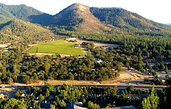
Ruch is an unincorporated community and census-designated place (CDP) in Jackson County, Oregon, United States. It is located on Oregon Route 238, southeast of Grants Pass. As of the 2010 census, it had a population of 840. [3]

Contents

Ruch was named after Casper M. Ruch, who bought a tract of land where the community now stands in 1896. He built a blacksmith shop, a store and a house. When he was appointed as a postmaster of the new post office in 1897 and allowed to name it. He named the post office after himself. The post office closed in 1939. [4]

There are two structures listed on the National Register of Historic Places in Ruch—McKee Bridge and Star Ranger Station.

The Ruch area is home to several Oregon wineries and in the Applegate Valley AVA, a sub-appellation of the Rogue Valley AVA (American Viticultural Area). A small elementary school, Ruch Elementary, is located near the center of the community. The school serves Kindergarten to 8th grade with the Cougars as their mascot.

The Applegate River runs through the southwest edge of the valley.

Demographics

Historical population
CensusPop.Note
2020 819
U.S. Decennial Census [5] [2]

Climate

Ruch has a warm-summer Mediterranean climate (Csb) according to the Köppen climate classification system.

Climate data for Ruch, Oregon, 1991–2020 normals, extremes 1963–present
MonthJanFebMarAprMayJunJulAugSepOctNovDecYear
Record high °F (°C)71
(22)
81
(27)
88
(31)
94
(34)
102
(39)
112
(44)
110
(43)
111
(44)
106
(41)
102
(39)
83
(28)
71
(22)
112
(44)
Mean maximum °F (°C)63.1
(17.3)
69.0
(20.6)
76.2
(24.6)
83.3
(28.5)
91.7
(33.2)
97.5
(36.4)
102.6
(39.2)
103.1
(39.5)
98.9
(37.2)
87.5
(30.8)
71.1
(21.7)
61.3
(16.3)
105.2
(40.7)
Mean daily maximum °F (°C)50.3
(10.2)
55.4
(13.0)
60.4
(15.8)
65.4
(18.6)
74.9
(23.8)
82.4
(28.0)
92.0
(33.3)
91.4
(33.0)
84.8
(29.3)
72.1
(22.3)
56.2
(13.4)
48.6
(9.2)
69.5
(20.8)
Daily mean °F (°C)40.2
(4.6)
43.0
(6.1)
46.6
(8.1)
50.9
(10.5)
58.5
(14.7)
64.7
(18.2)
72.0
(22.2)
71.0
(21.7)
64.9
(18.3)
55.0
(12.8)
44.6
(7.0)
39.3
(4.1)
54.2
(12.4)
Mean daily minimum °F (°C)30.1
(−1.1)
30.6
(−0.8)
32.9
(0.5)
36.3
(2.4)
42.2
(5.7)
47.1
(8.4)
52.0
(11.1)
50.7
(10.4)
44.9
(7.2)
38.0
(3.3)
33.1
(0.6)
30.1
(−1.1)
39.0
(3.9)
Mean minimum °F (°C)21.6
(−5.8)
22.6
(−5.2)
24.5
(−4.2)
27.4
(−2.6)
32.6
(0.3)
37.6
(3.1)
43.7
(6.5)
42.1
(5.6)
35.4
(1.9)
28.1
(−2.2)
22.9
(−5.1)
20.0
(−6.7)
17.5
(−8.1)
Record low °F (°C)8
(−13)
2
(−17)
18
(−8)
20
(−7)
25
(−4)
30
(−1)
34
(1)
32
(0)
22
(−6)
15
(−9)
12
(−11)
−3
(−19)
−3
(−19)
Average precipitation inches (mm)4.36
(111)
3.03
(77)
2.98
(76)
2.13
(54)
1.42
(36)
0.70
(18)
0.52
(13)
0.40
(10)
0.58
(15)
2.33
(59)
3.92
(100)
5.08
(129)
27.45
(698)
Average snowfall inches (cm)0.8
(2.0)
1.8
(4.6)
0.8
(2.0)
0.1
(0.25)
trace0.0
(0.0)
0.0
(0.0)
0.0
(0.0)
0.0
(0.0)
0.0
(0.0)
0.4
(1.0)
1.5
(3.8)
5.4
(13.65)
Average precipitation days (≥ 0.01 in)14.111.113.411.67.94.61.71.93.76.314.314.8105.4
Average snowy days (≥ 0.1 in)0.90.70.40.10.00.00.00.00.00.00.21.03.3
Source 1: NOAA (precip days, snow/snow days 19812010) [6] [7]
Source 2: National Weather Service [8]

Related Research Articles

<span class="mw-page-title-main">McDermitt, Nevada and Oregon</span> Unincorporated community in the state of Nevada, United States

McDermitt is an unincorporated community straddling the Nevada–Oregon border, in Humboldt County, Nevada, and Malheur County, Oregon, United States. McDermitt's economy has historically been based on mining, ranching, and farming. The last mining operation closed in 1990, resulting in a steady decline in population.

<span class="mw-page-title-main">Seneca, Oregon</span> City in Oregon, United States

Seneca is a city in Grant County, Oregon, United States. It is located in the Blue Mountains about 23 miles (37 km) south of Canyon City, on U.S. Route 395, on the edge of the Malheur National Forest. The population was 199 at the 2010 census.

<span class="mw-page-title-main">Cloverdale, Oregon</span> Census-designated place in Oregon, United States

Cloverdale is an unincorporated community in Tillamook County, Oregon, United States. For statistical purposes, the United States Census Bureau has defined Cloverdale as a census-designated place (CDP). The census definition of the area may not precisely correspond to local understanding of the area with the same name. The population was 242 at the 2000 census.

<span class="mw-page-title-main">La Grande, Oregon</span> City in Oregon, United States

La Grande is a city in Union County, Oregon, United States. La Grande is Union County's largest city, with a population of 13,082 at the time of the 2010 U.S. Census. The La Grande metro population is 25,076. It is the 16th largest metropolitan area in Oregon.

<span class="mw-page-title-main">Mapleton, Oregon</span> Unincorporated community in the state of Oregon, United States

Mapleton is an unincorporated community in Lane County, Oregon, United States. It is located on Oregon Route 126 and the Siuslaw River, 45 miles (72 km) west of Eugene and 15 miles (24 km) east of Florence. It is also the western terminus of Oregon Route 36. As of the 2000 census, Mapleton had a total population of 918.

<span class="mw-page-title-main">Mount Hood, Oregon</span> Unincorporated community in the state of Oregon, United States

Mount Hood is an unincorporated community and census-designated place (CDP) in Hood River County, Oregon, United States, about 3 miles (5 km) northeast of Parkdale on Oregon Route 35. As of the 2010 census it had a population of 286. Mount Hood is the terminus of Oregon Route 281, the Hood River Highway.

<span class="mw-page-title-main">Drewsey, Oregon</span> Unincorporated community in the state of Oregon, United States

Drewsey is an unincorporated community in Harney County, in the U.S. state of Oregon. Drewsey is along the main stem of the Malheur River, about 45 miles (72 km) east of Burns, off U.S. Route 20. It has the ZIP Code of 97904.

<span class="mw-page-title-main">Government Camp, Oregon</span> Census-designated place in Oregon, United States

Government Camp is an unincorporated community and census-designated place located in Clackamas County, Oregon, United States, on the base of Mount Hood and north of Tom Dick and Harry Mountain. It is the only town within 5 miles (8 km) of Mount Hood and therefore is the de facto "mountain town" or "ski town". It is the gateway to several ski resorts, with the most popular being Timberline Lodge and Mount Hood Skibowl. Government Camp also has its own, smaller ski resort, Summit Pass.

<span class="mw-page-title-main">Chemult, Oregon</span> Unincorporated community in the state of Oregon, United States

Chemult is an unincorporated community and census-designated place in Klamath County, Oregon, United States, on U.S. Route 97 near the drainage divide between the Klamath and Columbia Rivers. Chemult has a population of about 80 people. Chemult's elevation is 4,764 feet (1,452 m).

<span class="mw-page-title-main">Denio, Nevada</span> Unincorporated community in the state of Nevada, United States

Denio is a census-designated place (CDP) in Humboldt County, Nevada, along the Oregon state line in the United States. The Denio post office was originally north of the state line in Harney County, Oregon, but the residents moved the building into Nevada in the mid-20th century. The population of the CDP, which is entirely in Nevada, was 47 at the 2010 census; additional development considered to be Denio extends into Oregon. The CDP includes a post office, a community center, a library, and the Diamond Inn Bar, the center of the town's social life. Recreational activities in the Denio area include bird watching, photography, off road vehicle use, fishing, recreational black opal mining, rockhounding, hunting, visiting the hot springs, and camping on the Sheldon National Wildlife Refuge.

<span class="mw-page-title-main">Prospect, Oregon</span> Unincorporated community in the state of Oregon, United States

Prospect is an unincorporated community and census-designated place (CDP) in Jackson County, in the U.S. state of Oregon. It lies along Oregon Route 62 on the Rogue River, in the Rogue River – Siskiyou National Forest. As of the 2010 census it had a population of 455.

<span class="mw-page-title-main">Silver Lake, Oregon</span> Unincorporated community in the state of Oregon, United States

Silver Lake is an unincorporated community and census-designated place in western Lake County, Oregon, United States, along Oregon Route 31. As of the 2010 census, it had a population of 149. Facilities include a gas station and a small store, a post office, and a public school, North Lake School, serving grades K-12.

<span class="mw-page-title-main">Crane, Oregon</span> Unincorporated community in the state of Oregon, United States

Crane is a census-designated place and unincorporated community in Harney County, Oregon, United States, northeast of Malheur Lake on Oregon Route 78. Its population was 116 at the 2020 census.

<span class="mw-page-title-main">Winchester, Oregon</span> Unincorporated community in the state of Oregon, United States

Winchester is an unincorporated community in Douglas County, Oregon, United States. It is on the south bank of the North Umpqua River 4 miles (6.4 km) north of Roseburg on Interstate 5 and is included in the Roseburg North CDP for statistical purposes.

<span class="mw-page-title-main">Blodgett, Oregon</span> Unincorporated community in the state of Oregon, United States

Blodgett is a census-designated place (CDP) and unincorporated community in Benton County, Oregon, United States, where Oregon Route 180 meets U.S. Route 20 in the Central Oregon Coast Range 15 miles (24 km) west of Corvallis. It is near the confluence of the Tumtum and Marys rivers. As of the 2010 census, the community had a population of 58.

Riverside is an unincorporated community in Malheur County, Oregon, United States. It lies at an elevation of 3,343 feet (1,019 m) and is part of the Ontario, Oregon–Idaho Micropolitan Statistical Area. It is northeast of Crane and south of Juntura along Juntura–Riverside Road and the South Fork Malheur River near its confluence with the main stem.

<span class="mw-page-title-main">Williams, Oregon</span> Unincorporated community in the state of Oregon, United States

Williams is an unincorporated community and census-designated place (CDP) in Josephine County, Oregon, United States. As of the 2010 census it had a population of 1,072.

<span class="mw-page-title-main">Valley Falls, Oregon</span> Unincorporated community in the state of Oregon, United States

Valley Falls is a small unincorporated community in Lake County, Oregon, United States. The settled area is located at the junction of U.S. Route 395 and Oregon Route 31. The community is named for a small falls on the Chewaucan River just north of the occupied site. East of Valley Falls, the cliff face of Abert Rim overlooks the community.

<span class="mw-page-title-main">Lookingglass, Oregon</span> Community in Oregon, United States

Lookingglass is an unincorporated community and census-designated place in the Lookingglass Valley of Douglas County, Oregon, United States, about 9 miles (14 km) southwest of Roseburg. As of the 2010 census it had a population of 855. Lookingglass is considered a suburb of Roseburg.

Lacomb is a census-designated place and unincorporated community in Linn County, Oregon, United States, located about 10 miles (16 km) northeast of Lebanon. It was named in December 1889 by W.J. Turnidge, a son of a pioneer. As of the 2019 Census it had a population of 481.

References

  1. "ArcGIS REST Services Directory". United States Census Bureau. Retrieved October 12, 2022.
  2. 1 2 "Census Population API". United States Census Bureau. Retrieved October 12, 2022.
  3. "Geographic Identifiers: 2010 Census Summary File 1 (G001): Ruch CDP, Oregon". American Factfinder. U.S. Census Bureau. Archived from the original on February 13, 2020. Retrieved October 30, 2018.
  4. McArthur, Lewis A.; McArthur, Lewis L. (2003) [1928]. Oregon Geographic Names (7th ed.). Portland, Oregon: Oregon Historical Society Press. p. 830. ISBN   978-0875952772.
  5. "Census of Population and Housing". Census.gov. Retrieved June 4, 2016.
  6. "U.S. Climate Normals Quick Access – Station: Ruch, OR (19912020)". National Oceanic and Atmospheric Administration. Retrieved May 5, 2023.
  7. "U.S. Climate Normals Quick Access – Station: Ruch, OR (19812010)". National Oceanic and Atmospheric Administration. Retrieved May 5, 2023.
  8. "NOAA Online Weather Data – NWS Medford". National Weather Service. Retrieved May 5, 2023.