Gold Hill, Oregon

Last updated
Gold Hill, Oregon
Rock Point Hotel - Gold Hill Oregon.jpg
Rock Point Hotel, Gold Hill
Jackson County Oregon Incorporated and Unincorporated areas Gold Hill Highlighted.svg
Location in Oregon
Coordinates: 42°26′1″N123°3′16″W / 42.43361°N 123.05444°W / 42.43361; -123.05444 Coordinates: 42°26′1″N123°3′16″W / 42.43361°N 123.05444°W / 42.43361; -123.05444
Country United States
State Oregon
County Jackson
Incorporated 1895
Government
   Mayor Pro Tem Brad Studebaker
Area
[1]
  Total0.76 sq mi (1.97 km2)
  Land0.76 sq mi (1.97 km2)
  Water0.00 sq mi (0.00 km2)
Elevation
1,085 ft (330.7 m)
Population
 (2020) [2]
  Total1,335
  Density1,751.97/sq mi (676.77/km2)
Time zone UTC-8 (Pacific)
  Summer (DST) UTC-7 (Pacific)
ZIP code
97525
Area code 541
FIPS code 41-29950 [3]
GNIS feature ID1639311 [4]
Website www.cityofgoldhill.com

Gold Hill is a city in Jackson County, Oregon, in the United States. As of the 2010 census the population was 1,335. [5] It is along a bend of the Rogue River.

Contents

History

The City's name comes from a nearby hill that was the location of a 19th-century gold discovery, on "Big Bar” on the Rogue River in the early 1850s. In 1852, Colonel William T'Vault and family made a claim, naming it Dardanelles, on the south side of the Rogue. [6] Gold Hill became a boomtown overnight after time it became well known as pocket gold county. Seasoned prospectors specialized in placer mining from rivers, creeks, and streams. Gold Hill became world famous for its production of cement from area limestone deposit's. [7]

Geography

According to the United States Census Bureau, the city has a total area of 0.77 square miles (1.99 km2), all of it land. [8]

Gold Hill lies east of the city of Rogue River and northwest of Central Point and Medford along Interstate 5 and Oregon Route 99 in the Rogue River Valley. Gold Hill is connected to Shady Cove to the northeast by Oregon Route 234. [9]

Demographics

Historical population
CensusPop.Note
1900 385
1920 422
1930 50219.0%
1950 619
1960 608−1.8%
1970 603−0.8%
1980 90449.9%
1990 9646.6%
2000 1,07311.3%
2010 1,22013.7%
2020 1,3359.4%
U.S. Decennial Census [10] [2]

2010 census

As of the census of 2010, there were 1,220 people, 509 households, and 336 families living in the city. The population density was 1,584.4 inhabitants per square mile (611.7/km2). There were 552 housing units, at an average density of 716.9 per square mile (276.8/km2). The racial makeup of the city was 93.5% White, 0.2% African American, 1.6% Native American, 0.5% Asian, 0.7% from other races, and 3.6% from two or more races. Hispanic or Latino of any race were 2.7% of the population. [3]

There were 509 households, of which 27.3% had children under the age of 18 living with them, 46.4% were married couples living together, 12.4% had a female householder with no husband, 7.3% had a male householder with no wife, and 34.0% were non-families. 25.7% of all households were made up of individuals, and 8.6% had someone living alone who was 65 years of age or older. The average household size was 2.40 and the average family size was 2.83. [3]

The median age in the city was 43.9 years. 19.5% of residents were under the age of 18; 8.8% were between the ages of 18 and 24; 23.1% were from 25 to 44; 34.2% were from 45 to 64; and 14.4% were 65 years of age or older. The gender makeup of the city was 50.1% male and 49.9% female. [3]

2000 census

As of the census of 2000, there were 1,073 people, 419 households, and 294 families living in the city. The population density was 1,543.5 people per square mile (591.8/km2). There were 446 housing units at an average density of 641.6 per square mile (246.0/km2). The racial makeup of the city was 96.09% White, 0.09% African American, 1.96% Native American, 0.09% Asian, 0.09% Pacific Islander, 0.28% from other races, and 1.40% from two or more races. Hispanic or Latino of any race were 3.36% of the population. [3]

There were 419 households, out of which 35.8% had children under the age of 18 living with them, 49.6% were married couples living together, 14.6% had a female householder with no husband, and 29.8% were non-families. 23.9% of all households were made up of individuals, and 8.8% had someone living alone who was 65 years of age or older. The average household size was 2.56 and the average family size was 2.95. [3]

In the city, the population had 28.3% under the age of 18, 7.0% from 18 to 24, 27.4% from 25 to 44, 25.9% from 45 to 64, and 11.4% who were 65 years of age or older. The median age was 37 years. For every 100 females, there were 91.3 males. For every 100 females age 18 and over, there were 89.9 males. [3]

The median income for a household in the city was $32,500, and the median income for a family was $35,438. Males had a median income of $33,625 versus $23,036 for females. The per capita income for the city was $16,856. About 10.3% of families and 12.5% of the population were below the poverty line, including 15.3% of those under age 18 and 6.4% of those age 65 or over. [3]

Museums and other points of interest

Gold Hill is home to the Oregon Vortex, a roadside attraction. North of Gold Hill is Nugget Falls, a popular destination for whitewater kayaking.

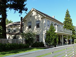
The Gold Hill Historical Society maintains a free museum in the 1901 Beeman–Martin House that is open Thursday through Saturday. The museum collection includes mining equipment, a stamp mill known as the Lucky Bart Stamp Mill (Owner, President - Bartholomew Signorritti - hence the name) Lucky Bart. He was also owner of the Lucky Bart Mining Company in Sacramento, California. The stamp mill was built by Union Iron Works of San Francisco, California (1892) [11] The stamp mill was purchased then shipped to for the Lucky Bart Mining Company of Sacramento to Gold Hill in the spring of 1893. Morton Lindley became president for the company Scientific press

Related Research Articles

<span class="mw-page-title-main">Josephine County, Oregon</span> County in Oregon, United States

Josephine County is one of the 36 counties in the U.S. state of Oregon. As of the 2020 census, the population was 88,090. The county seat is Grants Pass. The county is named after Virginia Josephine Rollins (1834-1912), a settler who was the first white woman to live in the county's boundaries. Josephine County comprises the Grants Pass, OR Metropolitan Statistical Area, which is included in the Medford-Grants Pass, OR Combined Statistical Area.

<span class="mw-page-title-main">Jackson County, Oregon</span> County in Oregon, United States

Jackson County is one of the 36 counties in the U.S. state of Oregon. As of the 2020 census, the population was 223,259. The county seat is Medford. The county is named for Andrew Jackson, the seventh president of the United States.

<span class="mw-page-title-main">Douglas County, Oregon</span> County in Oregon, United States

Douglas County is one of the 36 counties in the U.S. state of Oregon. As of the 2020 census, the population was 111,201. The county seat is Roseburg. The county is named after Stephen A. Douglas, an American politician who supported Oregon statehood. Douglas County comprises the Roseburg, OR Micropolitan Statistical Area.

<span class="mw-page-title-main">Baker County, Oregon</span> County in Oregon, United States

Baker County is one of the 36 counties in the U.S. state of Oregon. As of the 2020 census, the population was 16,668. The county seat and largest city is Baker City. The county was organized on September 22, 1862, when a portion of Wasco County was partitioned off. The new county's area was reduced in 1864 when Union County was partitioned off, and again in 1887 when Malheur County was partitioned off. The county's lines were last adjusted in 1901 when a parcel was added to the county.

<span class="mw-page-title-main">Rich Hill, Missouri</span> City in Missouri, United States

Rich Hill is a city in southern Bates County, Missouri, and is part of the Kansas City metropolitan area within the United States. The population was 1,232 at the 2020 census.

<span class="mw-page-title-main">Powers, Oregon</span> City in Oregon, United States

Powers is a city in Coos County, Oregon, United States. The population was 689 at the 2010 census.

<span class="mw-page-title-main">Gold Beach, Oregon</span> City in Oregon, United States

Gold Beach is a city in and the county seat of Curry County, Oregon, United States, on the Oregon Coast. The population was 2,241 at the 2020 census.

<span class="mw-page-title-main">Canyon City, Oregon</span> City in Oregon, United States

Canyon City is a city in Grant County, Oregon, United States. It is the county seat of Grant County, and is about 2 miles (3 km) south of John Day on U.S. Highway 395. As of the 2010 census, the city had a total population of 703.

<span class="mw-page-title-main">Granite, Oregon</span> City in Oregon, United States

Granite is a city in Grant County, in the U.S. state of Oregon. The city had a population of 38 in 2010, up from 24 in 2000. In 2010, it was the fourth-smallest incorporated city by population in Oregon. The smaller cities were Shaniko, Lonerock (21), and nearby Greenhorn (0).

<span class="mw-page-title-main">John Day, Oregon</span> City in Oregon, United States

John Day is a city located about 2 miles (3.2 km) north of Canyon City in Grant County, Oregon, at the intersection of U.S. Routes 26 and 395. The city was named for the nearby John Day River, which had been named for a Virginian member of the 1811 Astor Expedition, John Day. The city was incorporated in 1901.

<span class="mw-page-title-main">Central Point, Oregon</span> City in Oregon, United States

Central Point is a city in Jackson County, Oregon, United States. The population was 17,169 as of 2010. The city shares its southern border with Medford and is a part of the Medford metropolitan area. Central Point is home of the Jackson County Fair that occurs in July.

<span class="mw-page-title-main">Eagle Point, Oregon</span> City in Oregon, United States

Eagle Point is a city in Jackson County, Oregon, United States. The population was 8,469 at the 2010 census, up from 4,798 at the 2000 census. As of 2018, the estimated population was 9,408.

<span class="mw-page-title-main">Jacksonville, Oregon</span> City in Oregon, United States

Jacksonville is a city in Jackson County, Oregon, United States, approximately 5 miles (8 km) west of Medford. It was named for Jackson Creek, which flows through the community and was the site of one of the first placer gold claims in the area. It includes Jacksonville Historic District, which was designated a U.S. National Historic Landmark in 1966. As of the 2010 census, the city population was 2,785, up from 2,235 at the 2000 census.

<span class="mw-page-title-main">Rogue River, Oregon</span> City in Oregon, United States

Rogue River is a city in Jackson County, Oregon, United States. As of the 2020 census the population was 2,407.

<span class="mw-page-title-main">White City, Oregon</span> Unincorporated community in the state of Oregon, United States

White City is an unincorporated community and census-designated place (CDP) in Jackson County, Oregon, United States. The population was 7,975 at the 2010 census, up from 5,466 at the 2000 census. White City is about 9 miles (14 km) north of the center of Medford and 4 miles (6 km) south of Eagle Point.

<span class="mw-page-title-main">Jordan Valley, Oregon</span> City in Oregon, United States

Jordan Valley is a city in Malheur County, Oregon, United States. It is part of the Ontario, OR–ID Micropolitan Statistical Area. The city lies along Jordan Creek, a tributary of the Owyhee River; the creek is named for a 19th-century prospector, Michael M. Jordan. The population was 181 at the 2010 census.

<span class="mw-page-title-main">North Plains, Oregon</span> City in Oregon, United States

North Plains is a city in Washington County, Oregon, United States, off U.S. 26 on the northwest outskirts of the Portland metropolitan area. The population was 3,441 at the 2020 census.

<span class="mw-page-title-main">Central City, South Dakota</span> City in South Dakota, United States

Central City is a city in Lawrence County, South Dakota, United States. The population was 93 at the 2020 census.

<span class="mw-page-title-main">Mill City, Oregon</span> City in Oregon, United States

Mill City is a city in Linn and Marion counties in the U.S. state of Oregon on Oregon Route 22. The population was 1,971 at the 2020 census. It is on the North Santiam River, downstream from Detroit Lake.

<span class="mw-page-title-main">Shady Cove, Oregon</span> City in Oregon, United States

Shady Cove is a city in Jackson County, Oregon, United States. The population was 2,904 at the 2010 census.

References

  1. "ArcGIS REST Services Directory". United States Census Bureau. Retrieved October 12, 2022.
  2. 1 2 "Census Population API". United States Census Bureau. Retrieved Oct 12, 2022.
  3. 1 2 3 4 5 6 7 8 "U.S. Census website". United States Census Bureau . Retrieved 2012-12-21.
  4. "US Board on Geographic Names". United States Geological Survey. 2007-10-25. Retrieved 2008-01-31.
  5. "Geography Profile: 2020 Census Summary File 1 (G001): Gold Hill city, Oregon". American Factfinder. U.S. Census Bureau. Retrieved October 25, 2021.
  6. "City of Gold Hill History".
  7. McArthur, Lewis A.; Lewis L. McArthur (2003) [1928]. Oregon Geographic Names (7th ed.). Portland, Oregon: Oregon Historical Society Press. p. 410. ISBN   0-87595-277-1.
  8. "US Gazetteer files 2010". United States Census Bureau. Archived from the original on 2012-01-25. Retrieved 2012-12-21.
  9. Oregon Road & Recreation Atlas (5th ed.). Santa Barbara, California: Benchmark Maps. 2012. p. 96. ISBN   978-0-929591-62-9.
  10. "Census of Population and Housing". Census.gov. Retrieved June 4, 2015.
  11. "Gold Hill Historical Society". Jackson County Heritage Association. Retrieved October 14, 2015.