
Jackson County is one of the 36 counties in the U.S. state of Oregon. As of the 2020 census, the population was 223,259. The county seat is Medford. The county is named for Andrew Jackson, the seventh president of the United States.

The Rogue River in southwestern Oregon in the United States flows about 215 miles (346 km) in a generally westward direction from the Cascade Range to the Pacific Ocean. Known for its salmon runs, whitewater rafting, and rugged scenery, it was one of the original eight rivers named in the Wild and Scenic Rivers Act of 1968. Beginning near Crater Lake, which occupies the caldera left by the explosive volcanic eruption and collapse of Mount Mazama, the river flows through the geologically young High Cascades and the older Western Cascades, another volcanic province. Further west, the river passes through multiple exotic terranes of the more ancient Klamath Mountains. In the Kalmiopsis Wilderness section of the Rogue basin are some of the world's best examples of rocks that form the Earth's mantle. Near the mouth of the river, the only dinosaur fragments ever discovered in Oregon were found in the Otter Point Formation, along the coast of Curry County.
Camp Collins was a 19th-century outpost of the United States Army in the Colorado Territory. The fort was commissioned in the summer of 1862 to protect the Overland Trail from attacks by Native Americans in a conflict that later became known as the Colorado War. Located along the Cache la Poudre River in Larimer County, it was relocated from its initial location near Laporte after a devastating flood. Its second location downstream on the Poudre was used until 1866 and became the nucleus around which the City of Fort Collins was founded.
The Molala are a Native American people of Oregon that originally resided in the Western Cascades. There are few recorded sources about the Molala, the majority being unpublished manuscripts. This assortment includes the works of Albert S. Gatschet, Franz Boas, Leo J. Frachtenberg, Philip Drucker, Melville Jacobs, and Leslie Spier.

The Confederated Tribes of the Grand Ronde Community of Oregon (CTGR) is a federally recognized tribe of Indigenous peoples of the Northwest Plateau. They consist of at least 27 Native American tribes with long historical ties to present-day western Oregon between the western boundary of the Oregon Coast and the eastern boundary of the Cascade Range, and the northern boundary of southwestern Washington and the southern boundary of northern California.
The Rogue River Wars were an armed conflict in 1855–1856 between the U.S. Army, local militias and volunteers, and the Native American tribes commonly grouped under the designation of Rogue River Indians, in the Rogue River Valley area of what today is southern Oregon. The conflict designation usually includes only the hostilities that took place during 1855–1856, but there had been numerous previous skirmishes, as early as the 1830s, between European American settlers and the Native Americans, over territory and resources.
The Confederated Tribes of Siletz Indians in the United States is a federally recognized confederation of more than 27 Native American tribes and bands who once inhabited an extensive homeland of more than 20 million acres from northern California to southwest Washington and between the summit of the Cascades and the Pacific Ocean. After the Rogue River Wars, these tribes were removed to the Coast Indian Reservation, now known as the Siletz Reservation. The tribes spoke at least 11 distinct languages, including Tillamook, Shasta, Lower Chinook, Kalapuya, Takelma, Alsea-Yaquina, Siuslaw/Lower Umpqua, Coos, the Plateau Penutian languages Molala and Klickitat, and several related Oregon Athabaskan languages.

Umpqua National Forest, in southern Oregon's Cascade Range, covers an area of 983,129 acres (3,978.58 km2) in Douglas, Lane, and Jackson counties, and borders Crater Lake National Park. The four ranger districts for the forest are the Cottage Grove, Diamond Lake, North Umpqua, and Tiller ranger districts. The forest is managed by the United States Forest Service, headquartered in Roseburg.

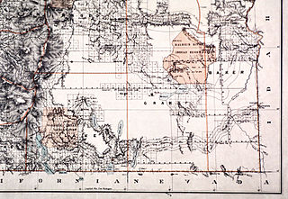
Table Rock Reservation was a short-lived Indian reservation north of the Rogue River in Oregon, United States. It was established by treaty with the Rogue River Indians in 1853. Following the conclusion of the Rogue River Wars in 1856, the Native American inhabitants were moved to other reservations. The reservation was in Southern Oregon, between Upper Table Rock and Evans Creek.
The Malheur Indian Reservation was an American Indian reservation established for the Northern Paiute in eastern Oregon and northern Nevada from 1872 to 1879. The federal government discontinued the reservation after the Bannock War of 1878, under pressure from European-American settlers who wanted the land. This negative recommendation against continuing by its agent William V. Rinehart, led to the internment of more than 500 Paiute on the Yakama Indian Reservation, as well as the reluctance of the Bannock and Paiute to return to the lands after the war.
Latgawa are Native American people who lived in the Rogue Valley of interior southwest Oregon. In their own language "Latgawa" /latʰka:wàʔ/ means "those living in the uplands," though they were also known as the Walumskni by the neighboring Klamath tribe.
The Oregon Superintendent of Indian Affairs was an official position of the U.S. state of Oregon, and previously of the Oregon Territory, that existed from 1848 to 1873.

Upper Table Rock and Lower Table Rock are two prominent volcanic plateaus located just north of the Rogue River in Jackson County, Oregon, U.S. Created by an andesitic lava flow approximately seven million years ago and shaped by erosion, they now stand about 800 feet (240 m) above the surrounding Rogue Valley. The Table Rocks are jointly owned; The Nature Conservancy is responsible for 3,591 acres (1,453 ha), while the Bureau of Land Management is responsible for 1,280 acres (520 ha).

Big Butte Creek is a 12-mile-long (19 km) tributary of the Rogue River in the U.S. state of Oregon. It drains approximately 245 square miles (635 km2) of Jackson County. Its two forks, the North Fork and the South Fork, both begin high in the Cascade Range near Mount McLoughlin. Flowing predominantly west, they meet near the city of Butte Falls. The main stem flows generally northwest until it empties into the Rogue Falls was incorporated in 1911, and remains the only incorporated town within the watershed's boundaries.
Siltcoos is an unincorporated community in Lane County, Oregon, United States. It is about 13 miles (21 km) south of Florence on the east shore of Siltcoos Lake.

The Willamette Valley is a 150-mile (240 km) long valley in Oregon, in the Pacific Northwest region of the United States. The Willamette River flows the entire length of the valley and is surrounded by mountains on three sides: the Cascade Range to the east, the Oregon Coast Range to the west, and the Calapooya Mountains to the south.

Charles Stewart Drew, also known as C.S. Drew, was a representative in the legislature of the Oregon Territory of the United States and quartermaster general of the territorial militia in the 1850s. During the American Civil War, he was a Union Army officer, serving in the 1st Oregon Cavalry regiment. He eventually reached the rank of lieutenant colonel. In 1864, he led an Army reconnaissance party into southeastern Oregon. The expedition, known as the Owyhee Reconnaissance, traveled through uncharted country from Fort Klamath to Fort Boise and back. Drew was the author of two historically important military reports; one documented Indian attacks on American settlers in the Oregon Territory and the other was his report of the Owyhee Reconnaissance.
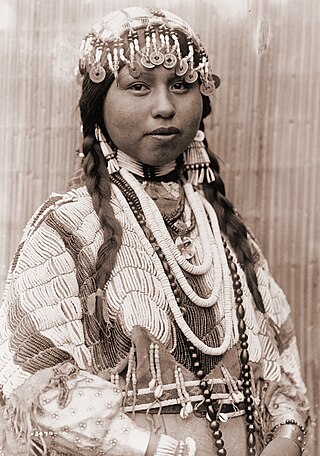
The Native American peoples of Oregon are the set of Indigenous peoples who have inhabited or who still inhabit the area delineated in today's state of Oregon in the Pacific Northwest region of the United States. While the state of Oregon currently maintains relations with nine federally recognized tribal groups, the state was previously home to a much larger number of autonomous tribal groups, which today either no longer exist or have been absorbed into these larger confederated entities. Six of the nine tribes gained federal recognition in the late 20th century, after undergoing the termination and restoration of their treaty rights starting in the 1950s.
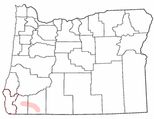
Table Rock is an unincorporated community in Jackson County, Oregon, United States. It lies near the Rogue River along Table Rock Road between White City and Sams Valley. The topographic features known as Upper and Lower Table Rock are slightly west of the community. Between 1853 and 1856, the Table Rock Indian Reservation lay between Upper Table Rock and Evans Creek, a Rogue River tributary to the west.


