Eagle Point, Oregon

Last updated

Eagle Point, Oregon
Eagle Point.jpg
An aerial image of Eagle Point
Nickname: 
Gateway to the Lakes
Jackson County Oregon Incorporated and Unincorporated areas Eagle Point Highlighted.svg
Location in Oregon
Coordinates: 42°28′4″N122°48′6″W / 42.46778°N 122.80167°W / 42.46778; -122.80167
Country United States
State Oregon
County Jackson
Incorporated 1911
Government
   Mayor Ruth Jenks [1]
Area
[2]
  Total2.97 sq mi (7.69 km2)
  Land2.97 sq mi (7.69 km2)
  Water0.00 sq mi (0.00 km2)
Elevation
1,310 ft (399.3 m)
Population
 (2020) [3]
  Total9,686
  Density3,263.48/sq mi (1,259.94/km2)
Time zone UTC-8 (Pacific)
  Summer (DST) UTC-7 (Pacific)
ZIP code
97524
Area code 541
FIPS code 41-21550 [4]
GNIS feature ID1161353 [5]
Website www.cityofeaglepoint.org

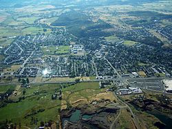
Eagle Point is a city in Jackson County, Oregon, United States. The population was 8,469 at the 2010 census, [6] up from 4,798 at the 2000 census. As of 2018, the estimated population was 9,408. [7]

Contents

History

In the mid-19th century, a rocky cliff near the location of what later became Eagle Point was a favored nesting place for eagles. An area resident, John Mathews, is said to have suggested "Eagle Point" as the name for a proposed post office in the community. The post office was established in 1872; Andrew McNeil was the first postmaster. [8]

A water-powered gristmill, Butte Creek Mill, has operated in Eagle Point for more than 125 years. Built in 1872 along Little Butte Creek, it was added to the National Register of Historic Places in 1976. [8] The mill burned to the ground Christmas Day 2015. The Butte Creek Mill has been rebuilt, with the first batch of grain being sold in December 2020. On May 15, 2016, Actor Jim Belushi performed at an outdoor benefit concert for the Butte Creek Mill. [9] In 2018, Actor Patrick Duffy, a longtime Eagle Point resident signed on as the Advisory Director for the Butte Creek Mill Foundation in an effort to rebuild the Butte Creek Mill. He joins actor Jim Belushi who has been a supporter since the mill burned. [10]


In 2018 Eagle Point Police Department Officer Daniel Cardenas shot and killed Matthew Graves. According to attorneys Kelly L. Anderson and David Linthorst, the “arrest” of Graves on mere suspicion alone is not grounds to detain him. “After making an unlawful arrest,” attorneys said, “Cardenas compounded the problem by using excessive force. In doing so, Cardenas himself created the very crisis for which he later claimed to have needed to use deadly force.”. Cardenas also made multiple discrepancies during his Grand Jury testimony which went against his protest of innocence. The City had to pay 4.5 Million Dollars for wrongful death. [11]

Geography

According to the United States Census Bureau, the city has a total area of 2.96 square miles (7.67 km2), all of it land. [12]

The city is north of Medford and White City and south of Shady Cove in the Rogue River Valley along Oregon Route 62. Little Butte Creek, a tributary of the Rogue River, passes through Eagle Point and enters the larger stream a few miles to the west near TouVelle State Recreation Site and Upper and Lower Table Rock. [13]

Climate

This region experiences warm (but not hot) and dry summers, with no average monthly temperatures above 71.6 °F (22.0 °C). According to the Köppen Climate Classification system, Eagle Point has a warm-summer Mediterranean climate, abbreviated "Csb" on climate maps. [14]

Demographics

Historical population
CensusPop.Note
1920 128
1930 21164.8%
1940 24315.2%
1950 607149.8%
1960 75223.9%
1970 1,24165.0%
1980 2,764122.7%
1990 3,0088.8%
2000 4,79859.5%
2010 8,46976.5%
2020 9,67714.3%
2021 (est.)9,865 [15] 1.9%
U.S. Decennial Census [16] [3]

2010 census

At the 2010 census, there were 8,469 people, 3,231 households, and 2,373 families living in the city. The population density was 2,861.1 inhabitants per square mile (1,104.7/km2). There were 3,611 housing units at an average density of 1,219.9 per square mile (471.0/km2). The racial makeup of the city was 92.1% White, 0.2% African American, 1.3% Native American, 1.0% Asian, 0.1% Pacific Islander, 1.7% from other races, and 3.6% from two or more races. Hispanic or Latino of any race were 6.8% of the population. [4]

Of the 3,231 households 37.5% had children under the age of 18 living with them, 55.9% were married couples living together, 12.0% had a female householder with no husband present, 5.5% had a male householder with no wife present, and 26.6% were non-families. 20.9% of households were one person and 9.7% were one person aged 65 or older. The average household size was 2.62 and the average family size was 3.01. [4]

The median age was 36.9 years. 27.3% of residents were under the age of 18; 6.7% were between the ages of 18 and 24; 26.2% were from 25 to 44; 25.5% were from 45 to 64; and 14.2% were 65 or older. The gender makeup of the city was 48.1% male and 51.9% female. [4]

2000 census

At the 2000 census, there were 4,797 people, 1,703 households, and 1,313 families living in the city. The population density was 1,869.9 inhabitants per square mile (722.0/km2). There were 1,823 housing units at an average density of 710.6 per square mile (274.4/km2). The racial makeup of the city was 93.16% White, 0.38% African American, 1.73% Native American, 0.40% Asian, 0.19% Pacific Islander, 1.10% from other races, and 3.04% from two or more races. Hispanic or Latino of any race were 3.52% of the population. [4]

Of the 1,703 households 45.6% had children under the age of 18 living with them, 56.9% were married couples living together, 14.6% had a female householder with no husband present, and 22.9% were non-families. 18.1% of households were one person and 8.1% were one person aged 65 or older. The average household size was 2.82 and the average family size was 3.17. In the city, the population was 32.6% under the age of 18, 9.4% from 18 to 24, 29.2% from 25 to 44, 19.7% from 45 to 64, and 9.1% 65 or older. The median age was 30 years. For every 100 females, there were 93.2 males. For every 100 females age 18 and over, there were 89.7 males. The median household income was $37,557 and the median family income was $40,598. Males had a median income of $30,795 versus $20,956 for females. The per capita income for the city was $15,501. About 11.4% of families and 12.8% of the population were below the poverty line, including 18.7% of those under age 18 and 15.1% of those age 65 or over. [4]

Notable people

See also

Related Research Articles

<span class="mw-page-title-main">Meade County, South Dakota</span> County in South Dakota, United States

Meade County is a county in the U.S. state of South Dakota. As of the 2020 census, the population was 29,852. Its county seat is Sturgis. The county was created in 1889 and named for Fort Meade, which was garrisoned as a United States military post in the area in 1878 and itself named for General George Meade.

<span class="mw-page-title-main">Corson County, South Dakota</span> County in South Dakota, United States

Corson County is a county in the U.S. state of South Dakota. As of the 2020 census, the population was 3,902. Its county seat is McIntosh. The county was named for Dighton Corson, a native of Maine, who came to the Black Hills in 1876, and in 1877 began practicing law at Deadwood.

<span class="mw-page-title-main">Jackson County, Oregon</span> County in Oregon, United States

Jackson County is one of the 36 counties in the U.S. state of Oregon. As of the 2020 census, the population was 223,259. The county seat is Medford. The county is named for Andrew Jackson, the seventh president of the United States.

<span class="mw-page-title-main">Deschutes County, Oregon</span> County in Oregon, United States

Deschutes County is one of the 36 counties in the U.S. state of Oregon. As of the 2020 census, the population was 198,253. The county seat is Bend. The county was created in 1916 out of part of Crook County and was named for the Deschutes River, which itself was named by French-Canadian trappers of the early 19th century. It is the political and economic hub of Central Oregon. Deschutes comprises the Bend, Oregon Metropolitan Statistical Area. Deschutes is Oregon's fastest-growing and most recently formed county.

<span class="mw-page-title-main">Crook County, Oregon</span> County in Oregon, United States

Crook County is one of the 36 counties in the U.S. state of Oregon. As of the 2020 census, the population was 24,738. The county seat is Prineville. The county is named after George Crook, a U.S. Army officer who served in the American Civil War and various Indian Wars.

<span class="mw-page-title-main">Myrtle Creek, Oregon</span> City in Oregon, United States

Myrtle Creek is a city in Douglas County, Oregon, United States. The population was 3,439 at the 2010 census.

<span class="mw-page-title-main">Tri-City, Oregon</span> Unincorporated community in the state of Oregon, United States

Tri-City is a census-designated place (CDP) and unincorporated community in Douglas County, Oregon, United States. The population was 3,931 at the 2010 census. The community in Missouri Bottom near the Umpqua River is named for the three cities among which it is centered: Myrtle Creek, Canyonville and Riddle. The Tri City School District probably originated the name, which was later adopted by the local sewer district and the former Tri City State Airport.

<span class="mw-page-title-main">Butte Falls, Oregon</span> City in Oregon, United States

Butte Falls is a city in Jackson County, Oregon, United States. The population was 423 at the 2010 census. As of July 1, 2018, the city's population was estimated to be 450.

<span class="mw-page-title-main">Gold Hill, Oregon</span> City in Jackson County, Oregon, United States

Gold Hill is a city in Jackson County, Oregon, in the United States. As of the 2010 census the population was 1,335. It is along a bend of the Rogue River.

<span class="mw-page-title-main">Phoenix, Oregon</span> City in Oregon, United States

Phoenix is a city in Jackson County, Oregon, United States. The population was 4,538 at the 2010 census. Phoenix is a part of the Medford Metropolitan Statistical Area, in the Rogue Valley, and is 3 miles (5 km) southeast of Medford on Interstate 5.

<span class="mw-page-title-main">Rogue River, Oregon</span> City in Oregon, United States

Rogue River is a city in Jackson County, Oregon, United States. As of the 2020 census the population was 2,407.

<span class="mw-page-title-main">Scio, Oregon</span> City in Oregon, United States

Scio is a city in Linn County, Oregon, United States. The population was 838 at the 2010 census.

<span class="mw-page-title-main">Mt. Angel, Oregon</span> City in Marion County, Oregon

Mt. Angel is a city in Marion County, Oregon, United States. It is 18 miles (29 km) northeast of Salem, Oregon, on Oregon Route 214. The population was 3,392 at the 2020 census. Mt. Angel is part of the Salem Metropolitan Statistical Area.

<span class="mw-page-title-main">Scotts Mills, Oregon</span> City in Oregon, United States

Scotts Mills is a city in Marion County, Oregon, United States. The population was 419 at the 2020 census. It is 2 miles (3 km) south of Marquam and Oregon Route 213, between Silverton and Molalla.

<span class="mw-page-title-main">Independence, Oregon</span> City in Oregon, United States

Independence is a city in Polk County, Oregon, United States, on the west bank of the Willamette River along Oregon Route 51, and east of nearby Monmouth. It is part of the Salem Metropolitan Statistical Area. Thirty square blocks of the oldest part of Independence form the National Register of Historic Places-listed Independence Historic District.

<span class="mw-page-title-main">Mitchell, Oregon</span> City in Oregon, United States

Mitchell is a city in Wheeler County, Oregon, United States. The population was 130 at the 2010 census. It was founded in 1873 and was named after John H. Mitchell, a politician.

<span class="mw-page-title-main">Green Grass, South Dakota</span> CDP in South Dakota, United States

Green Grass is a census-designated place (CDP) in Dewey County, South Dakota, United States. The population was 21 at the 2020 census.

<span class="mw-page-title-main">North Eagle Butte, South Dakota</span> Census-designated place in South Dakota, United States

North Eagle Butte is a census-designated place (CDP) in Dewey County, South Dakota, United States, along the 45th parallel. The population was 1,879 at the 2020 census.

<span class="mw-page-title-main">Mill Creek, West Virginia</span> Town in West Virginia, United States

Mill Creek is a town in Randolph County, West Virginia, United States, along the Tygart Valley River. The population was 563 at the 2020 census.

<span class="mw-page-title-main">Mill City, Oregon</span> City in Oregon, United States

Mill City is a city in Linn and Marion counties in the U.S. state of Oregon on Oregon Route 22. The population was 1,971 at the 2020 census. It is on the North Santiam River, downstream from Detroit Lake.

References

  1. "Eagle Point City Council Members and Mayor" . Retrieved May 10, 2021.
  2. "ArcGIS REST Services Directory". United States Census Bureau. Retrieved October 12, 2022.
  3. 1 2 "Census Population API". United States Census Bureau. Retrieved October 12, 2022.
  4. 1 2 3 4 5 6 "U.S. Census website". United States Census Bureau . Retrieved December 21, 2012.
  5. "US Board on Geographic Names". United States Geological Survey. October 25, 2007. Retrieved January 31, 2008.
  6. "Geographic Identifiers: 2010 Census Summary File 1 (G001): Eagle Point city, Oregon". American Factfinder. U.S. Census Bureau. Archived from the original on February 13, 2020. Retrieved October 24, 2018.
  7. "Population and Housing Unit Estimates" . Retrieved June 4, 2019.
  8. 1 2 McArthur, Lewis A.; Lewis L. McArthur (2003) [1928]. Oregon Geographic Names (7th ed.). Portland, Oregon: Oregon Historical Society Press. p. 312. ISBN   0-87595-277-1.
  9. "Jim Belushi concert will benefit Butte Creek Mill | Mail Tribune". mailtribune.com. Archived from the original on May 13, 2019.
  10. "Stars align for Butte Creek Mill rebuild | Mail Tribune". mailtribune.com. Archived from the original on May 28, 2018.
  11. "$4.5 million settlement reached in shooting death of Matthew Graves". January 21, 2020.
  12. "US Gazetteer files 2010". United States Census Bureau. Archived from the original on July 2, 2012. Retrieved December 21, 2012.
  13. Oregon Road & Recreation Atlas (5th ed.). Santa Barbara, California: Benchmark Maps. 2012. p. 96. ISBN   978-0-929591-62-9.
  14. "Eagle Point, Oregon". Weatherbase. CantyMedia. Retrieved October 13, 2015.
  15. "Population and Housing Unit Estimates". United States Census Bureau. May 24, 2020. Retrieved May 27, 2020.
  16. "Census of Population and Housing". Census.gov. Retrieved June 4, 2015.
  17. "Patrick Duffy Biography Channel bio". Archived from the original on March 18, 2012. Retrieved January 2, 2011.
  18. "Tyrone Holmes Stats". Pro-Football-Reference.com . Retrieved October 2, 2020.
  19. "Kim Novak Mail Tribune". Archived from the original on October 9, 2008. Retrieved January 2, 2011.