Trail, Oregon

Last updated
Trail, Oregon
Trail Oregon.jpg
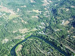
An aerial image of Trail and the Rogue River
USA Oregon location map.svg
Red pog.svg
Trail
Usa edcp location map.svg
Red pog.svg
Trail
Coordinates: 42°38′54″N122°48′38″W / 42.64833°N 122.81056°W / 42.64833; -122.81056 Coordinates: 42°38′54″N122°48′38″W / 42.64833°N 122.81056°W / 42.64833; -122.81056
Country United States
State Oregon
County Jackson
Area
[1]
  Total6.88 sq mi (17.83 km2)
  Land6.80 sq mi (17.62 km2)
  Water0.08 sq mi (0.21 km2)
Elevation
[2]
1,430 ft (440 m)
Population
 (2020) [3]
  Total768
  Density112.91/sq mi (43.59/km2)
Time zone UTC-8 (Pacific (PST))
  Summer (DST) UTC-7 (PDT)
ZIP code
97541
FIPS code 41-74400
GNIS feature ID1151362

Trail is a census-designated place and unincorporated community in Jackson County, Oregon, United States. As of the 2010 census it had a population of 702. [4] It has a post office with a ZIP code of 97541. [2] [5]

Contents

Trail lies at the intersection of Oregon Route 227 and Oregon Route 62, just north of Shady Cove and west of Lost Creek Lake, a reservoir of the Rogue River. Trail is located around the mouth of Trail Creek at the Rogue River. [6]

Demographics

Historical population
CensusPop.
2020 768
U.S. Decennial Census [7] [3]

Climate

This region experiences warm (but not hot) and dry summers, with no average monthly temperatures above 71.6 °F. According to the Köppen Climate Classification system, Trail has a warm-summer Mediterranean climate, abbreviated "Csb" on climate maps. [8]

Related Research Articles

<span class="mw-page-title-main">Coal Creek, Jefferson County, Colorado</span> Census-designated place in Boulder, Gilpin, and Jefferson counties in Colorado, United States

Coal Creek, commonly known as Coal Creek Canyon, is a census-designated place (CDP) located in and governed by Jefferson, Boulder, and Gilpin counties in Colorado, United States, but primarily Jefferson County. The population of the Coal Creek CDP was 2,400 at the United States Census 2010. The Golden post office serves the area.

<span class="mw-page-title-main">Cascade Locks, Oregon</span> City in Oregon, United States

Cascade Locks is a city in Hood River County, Oregon, United States. The city took its name from a set of locks built to improve navigation past the Cascades Rapids of the Columbia River. The U.S. federal government approved the plan for the locks in 1875, construction began in 1878, and the locks were completed on November 5, 1896. The locks were subsequently submerged in 1938, replaced by Bonneville Lock and Dam, although the city lost no land from the expansion of Lake Bonneville behind the dam some 4 miles (6 km) downstream of the city. The city population was 1,144 at the 2010 census.

<span class="mw-page-title-main">White City, Oregon</span> Unincorporated community in the state of Oregon, United States

White City is an unincorporated community and census-designated place (CDP) in Jackson County, Oregon, United States. The population was 7,975 at the 2010 census, up from 5,466 at the 2000 census. White City is about 9 miles (14 km) north of the center of Medford and 4 miles (6 km) south of Eagle Point.

Selma is an unincorporated community and census-designated place (CDP) in Josephine County, Oregon, United States. As of the 2010 census it had a population of 695. It is located in the ZIP code of 97538.

Beatty is an unincorporated community and census-designated place (CDP) in Klamath County, Oregon, United States. Beatty is along Oregon Route 140 at the confluence of the Sycan and Sprague rivers and is 40 miles (64 km) by highway northeast of Klamath Falls.

<span class="mw-page-title-main">Camp Sherman, Oregon</span> Unincorporated community in the state of Oregon, United States

Camp Sherman is an unincorporated community and census-designated place (CDP) in Jefferson County, Oregon, United States. It is located on the Metolius River. The year-round population as of the 2010 census was 233, with that number tripling or more during the summer. The community includes an elementary school, Black Butte School, a general store and a post office. The community also has a volunteer fire department. Camp Sherman was founded by vacationers from Sherman County in the latter part of the 19th century.

<span class="mw-page-title-main">Cascadia, Oregon</span> Unincorporated community in the state of Oregon, United States

Cascadia is an unincorporated community and census-designated place (CDP) that was established in 1892 on the South Santiam River, 14 miles (23 km) east of the current city of Sweet Home, in Linn County, Oregon, United States. As of the 2010 census it had a population of 147.

<span class="mw-page-title-main">Prospect, Oregon</span> Unincorporated community in the state of Oregon, United States

Prospect is an unincorporated community and census-designated place (CDP) in Jackson County, in the U.S. state of Oregon. It lies along Oregon Route 62 on the Rogue River, in the Rogue River – Siskiyou National Forest. As of the 2010 census it had a population of 455.

<span class="mw-page-title-main">Eagle Creek, Oregon</span> Unincorporated community in the state of Oregon, United States

Eagle Creek is an unincorporated community in Clackamas County, Oregon, United States. It is located seven miles southwest of Sandy, seven miles north of Estacada, and five miles southeast of Carver, at the junction of Oregon Routes 224 and 211, on the Clackamas River.

<span class="mw-page-title-main">Days Creek, Oregon</span> Unincorporated community in the state of Oregon, United States

Days Creek is an unincorporated community and census-designated place in Douglas County, Oregon, United States. At the 2010 census it had a population of 272.

Oak Ridge is an unincorporated community located along the border of West Milford Township in Passaic County and Jefferson Township in Morris County, New Jersey, United States. The area is served as United States Postal Service ZIP Code 07438.

<span class="mw-page-title-main">Wedderburn, Oregon</span> Unincorporated community in the state of Oregon, United States

Wedderburn is an unincorporated coastal community in Curry County, Oregon, United States. It is to the north of, and across the mouth of the Rogue River from Gold Beach, on U.S. Route 101. The Isaac Lee Patterson Bridge connects Wedderburn with Gold Beach.

<span class="mw-page-title-main">Blodgett, Oregon</span> Unincorporated community in the state of Oregon, United States

Blodgett is a census-designated place (CDP) and unincorporated community in Benton County, Oregon, United States, where Oregon Route 180 meets U.S. Route 20 in the Central Oregon Coast Range 15 miles (24 km) west of Corvallis. It is near the confluence of the Tumtum and Marys rivers. As of the 2010 census, the community had a population of 58.

<span class="mw-page-title-main">Williams, Oregon</span> Unincorporated community in the state of Oregon, United States

Williams is an unincorporated community and census-designated place (CDP) in Josephine County, Oregon, United States. As of the 2010 census it had a population of 1,072.

<span class="mw-page-title-main">New Pine Creek, Oregon</span> Unincorporated community in the state of Oregon, United States

New Pine Creek is a census-designated place and unincorporated community in Lake County, Oregon, United States. As of the 2010 census, it had a population of 120. it has a post office with a ZIP code 97635. New Pine Creek lies on U.S. Route 395 at the Oregon–California border, just north of New Pine Creek, California, and east of Goose Lake.

<span class="mw-page-title-main">Dillard, Oregon</span> Unincorporated community in the state of Oregon, United States

Dillard is an unincorporated community and census-designated place in Douglas County, Oregon, United States. Dillard is south of the city of Winston. Dillard has a post office with ZIP code 97432. As of the 2010 census, it had a population of 478.

Crescent is an unincorporated community in Klamath County, Oregon, United States. Crescent is along U.S. Route 97 about 47 miles (76 km) south-southwest of Bend. Crescent has a post office with ZIP code 97733.

<span class="mw-page-title-main">De Smet, Idaho</span> Census-designated place in Idaho, United States

De Smet is an unincorporated census-designated place in the northwestern United States, located on the Coeur d'Alene Reservation in Benewah County, Idaho.

Albrightsville is an unincorporated community and census-designated place in Kidder and Penn Forest townships, Carbon County, Pennsylvania, United States. It is part of Northeastern Pennsylvania.

Marion is a census-designated place and unincorporated community in Flathead County, Montana, United States. Its population was 886 as of the 2010 census. Marion has a post office with ZIP code 59925.

References

  1. "ArcGIS REST Services Directory". United States Census Bureau. Retrieved October 12, 2022.
  2. 1 2 "Trail". Geographic Names Information System . United States Geological Survey, United States Department of the Interior. November 28, 1980. Retrieved December 8, 2013.
  3. 1 2 "Census Population API". United States Census Bureau. Retrieved Oct 12, 2022.
  4. "Geographic Identifiers: 2010 Census Summary File 1 (G001): Trail CDP, Oregon". American Factfinder. U.S. Census Bureau. Archived from the original on February 13, 2020. Retrieved October 30, 2018.
  5. Zip Code Lookup
  6. "Trail, OR". Google Maps. Retrieved December 8, 2013.
  7. "Census of Population and Housing". Census.gov. Retrieved June 4, 2016.
  8. Climate Summary for Trail, Oregon