
The Erie Canal is a historic canal in upstate New York that runs east–west between the Hudson River and Lake Erie. Completed in 1825, the canal was the first navigable waterway connecting the Atlantic Ocean to the Great Lakes, vastly reducing the costs of transporting people and goods across the Appalachians. The Erie Canal accelerated the settlement of the Great Lakes region, the westward expansion of the United States, and the economic ascendancy of New York state. It has been called "The Nation's First Superhighway."
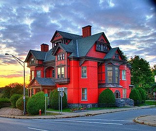
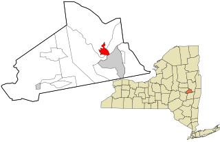
Montgomery County is a county in the U.S. state of New York. As of the 2020 census, the population was 49,532. The county seat is Fonda. The county was named in honor of Richard Montgomery, an American Revolutionary War general killed in 1775 at the Battle of Quebec. The county is part of the Mohawk Valley region of the state.

Montezuma is a town in Cayuga County, New York, United States. The population was 1,277 at the 2010 census.
Clifton Park is a suburban town in Saratoga County, New York, United States. It is the largest municipality in the county, with a 2020 population of 38,029, according to the 2020 census. The name is derived from an early land patent. The town is in the southern part of Saratoga County, approximately 12 miles (19 km) north of Albany, 7 miles (11 km) northeast of Schenectady, and 10 miles (16 km) south of Saratoga Springs.
Halfmoon is a town in Saratoga County, New York, United States. The population was 25,662 at the 2020 census. The town is apparently named for the shape of the lower elevation land north of the junction of the Hudson and Mohawk Rivers. It is also said to be named for Henry Hudson's ship, the Halve Maen.
Scotia is a village in Schenectady County, New York, United States, incorporated in 1904. The population was 7,272 at the 2020 census. Scotia is part of the town of Glenville, and is connected with the city of Schenectady by the Western Gateway Bridge over the Mohawk River.

Waterford is a village in Saratoga County, New York, United States. The population was 2,038 at the 2020 census. The name derives from the ford between the mainland and Peebles Island.

The New York Central Railroad was a railroad primarily operating in the Great Lakes and Mid-Atlantic regions of the United States. The railroad primarily connected greater New York and Boston in the east with Chicago and St. Louis in the Midwest, along with the intermediate cities of Albany, Buffalo, Cleveland, Cincinnati, Detroit, Rochester and Syracuse. New York Central was headquartered in New York City's New York Central Building, adjacent to its largest station, Grand Central Terminal.

Interstate 890 (I-890) is a 9.35-mile-long (15.05 km) auxiliary Interstate Highway in the vicinity of Schenectady, New York, in the United States. The highway runs southeast–northwest from an interchange with the New York State Thruway (I-90) northwest of Schenectady to another junction with the thruway south of the city and passes through Downtown Schenectady along the way. Most of I-890 is six lanes wide, including a section that runs above an industrial section of Schenectady on an elevated highway. I-890 is a local, toll-free alternative to the thruway, which bypasses the city and its suburbs to the southwest.
Rexford is a hamlet in Saratoga County, New York, United States, located on the north bank of the Mohawk River. Rexford is in the Town of Clifton Park, near the southwestern town line. Its boundaries, like those of neighboring Alplaus, are unofficial and necessarily ambiguous. To the south, it is bounded by the Mohawk River and Grooms Road and to the west, Alplaus and the Schenectady County line. Route 146 and Vischer's Ferry Road, are probably a reasonable delineations of its northern and eastern boundaries. The ZIP Code is 12148.

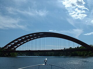
Bridge 8, known locally as the Rexford Bridge, is a four-lane bridge crossing the Mohawk River northeast of the city of Schenectady in New York, United States. It carries New York State Route 146 (NY 146) from Schenectady County to Rexford, a hamlet in the Saratoga County town of Clifton Park.
Dunsbach Ferry is a hamlet of the town of Colonie, in Albany County, New York, United States. The hamlet sits to the east of, and below, the Thaddeus Kosciusko Bridge, where Interstate 87 (I-87) crosses the Mohawk River. There are numerous private and public docks and landings between the Twin Bridges and the Colonie Town Park. Dunsbach Ferry was once an important river crossing and a stop on the Schenectady and Troy Railroad (T&S), later a branch of the New York Central Railroad. The ZIP code is 12047 (Cohoes).

New York State Route 146 (NY 146) is a state highway in the Capital District of New York in the United States. It extends for 43 miles (69 km) from Gallupville at NY 443 to near Mechanicville at U.S. Route 4 (US 4) and NY 32. NY 146 is a major thoroughfare in the city of Schenectady, just outside Albany. Most of the route follows an east–west alignment; however, the middle third of the route between Guilderland and Clifton Park runs in a more north–south manner in order to serve Schenectady. At one time, NY 146 had three spur routes; only one—NY 146A—still exists.

Crescent Bridge is a 1,229-foot (375 m) bridge over the Mohawk River and the Erie Canal. It is in Crescent, New York, a hamlet in the town of Halfmoon in southern Saratoga County on the northern side of the Mohawk River. The Crescent Bridge carries U.S Route 9 over the Mohawk River between the towns of Colonie in Albany County and Halfmoon.

New York State Route 103 (NY 103) is a state highway in Schenectady County, New York, in the United States. It runs for just 0.50 miles (0.80 km) from an intersection with NY 5S in the hamlet of Rotterdam Junction to NY 5 in the town of Glenville. In between, the route crosses the Mohawk River at Erie Canal at Lock 9. When it was assigned in the early 1930s, it was the only crossing of the Mohawk River between Pattersonville and downtown Schenectady. It later became the only bridge between Amsterdam and Schenectady. Its regional importance declined following the completion of NY 890 near Schenectady in 1998. In late 2011, NY 103 was closed for three months to repair parts of the road damaged by Hurricane Irene and Tropical Storm Lee.
Central Avenue, in Albany, New York, is an 18 km stretch in Albany County, of the 26 km Albany-Schenectady Turnpike, which runs from Lark Street in the city of Albany, westward through the towns of Colonie, New York and Niskayuna, New York, to the city of Schenectady, New York. In the city of Albany it is called Central Avenue, in Colonie it is known as Central Avenue or Albany Schenectady Road, and in Schenectady County it is called State Street. The entire route is designated as a part of New York State Route 5, which stretches to the Pennsylvania state line and terminates at Central Avenue's east end.
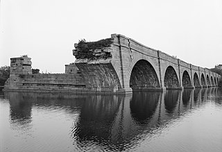
Schoharie Crossing State Historic Site, also known as Erie Canal National Historic Landmark, is a historic district that includes the ruins of the Erie Canal aqueduct over Schoharie Creek, and a 3.5-mile (5.6 km) long part of the Erie Canal, in the towns of Glen and Florida within Montgomery County, New York. It was the first part of the old canal to be designated a National Historic Landmark, prior to the designation of the entire New York State Barge Canal as an NHL in 2017.
Fort Hunter is a hamlet in the Town of Florida in Montgomery County, New York, United States, west of the capital at Albany, on the south bank of the Mohawk River and on the northeast bank of Schoharie Creek.

The Mohawk Towpath Scenic Byway is a National Scenic Byway in the Capital District region of New York in the United States. It extends from Schenectady to Waterford by way of a series of local, county, and state highways along the Mohawk River and the Erie Canal. The byway is intended to showcase the history of the waterway, from Native American times through the creation of the Erie Canal and the role the waterside communities played in the Industrial Revolution and the westward expansion of the United States. At its east end, the byway connects to the Lakes to Locks Passage, an All-American Road.
Crescent is a hamlet in the town of Halfmoon, New York, United States. It lies on the north bank of the Mohawk River in Saratoga County.


