Interstate 890 (I-890) is a 9.45-mile-long (15.21 km) auxiliary Interstate Highway in the vicinity of Schenectady, New York, in the United States. The highway runs southeast–northwest from an interchange with the New York State Thruway (I-90) northwest of Schenectady to another junction with the Thruway south of the city and passes through Downtown Schenectady along the way. Most of I-890 is six lanes wide, including a section that runs above an industrial section of Schenectady on an elevated highway. I-890 is a local, toll-free alternative to the Thruway, which bypasses the city and its suburbs to the southwest.
New York State Route 5 (NY 5) is a state highway that extends for 370.80 miles (596.74 km) across the state of New York in the United States. It begins at the Pennsylvania state line in the Chautauqua County town of Ripley and passes through Buffalo, Syracuse, Utica, Schenectady, and several other smaller cities and communities on its way to downtown Albany in Albany County, where it terminates at U.S. Route 9 (US 9), here routed along the service roads for Interstate 787 (I-787). Prior to the construction of the New York State Thruway, it was one of two main east–west highways traversing upstate New York, the other being US 20. West of New York, NY 5 continues as Pennsylvania Route 5 (PA 5) to Erie.

Rexford is a hamlet in Saratoga County, New York, United States, located on the north bank of the Mohawk River. Rexford is in the Town of Clifton Park, near the southwestern town line. Its boundaries, like those of neighboring Alplaus, are unofficial and necessarily ambiguous. To the south, it is bounded by the Mohawk River and Grooms Road and to the west, Alplaus and the Schenectady County line. Route 146 and Vischer's Ferry Road, are probably a reasonable delineations of its northern and eastern boundaries. The ZIP Code is 12148.
New York State Route 146 (NY 146) is a state highway in the Capital District of New York in the United States. It extends for 43 miles (69 km) from Gallupville at NY 443 to near Mechanicville at U.S. Route 4 (US 4) and NY 32. NY 146 is a major thoroughfare in the city of Schenectady, just outside Albany. Most of the route follows an east–west alignment; however, the middle third of the route between Guilderland and Clifton Park runs in a more north–south manner in order to serve Schenectady. At one time, NY 146 had three spur routes; only one—NY 146A—still exists.
New York State Route 240 (NY 240) is a 51.64-mile (83.11 km) state highway in western New York in the United States. The southern terminus of the route is at an intersection with NY 242 in the Ellicottville community of Ashford Junction in northern Cattaraugus County. Its northern terminus is at a junction with NY 324 and Interstate 290 (I-290) in Amherst in northern Erie County. The route passes through the villages of Springville and Orchard Park, where it meets NY 39 and U.S. Route 20A (US 20A), respectively. Much of NY 240 between Concord and Aurora follows the west branch of Cazenovia Creek. The northern part of NY 240 in Erie County, named Harlem Road, is a major north–south route through the suburbs east of the city of Buffalo.
New York State Route 30 (NY 30) is a state highway in the central part of New York in the United States. It extends for 300.71 miles (483.95 km) from an interchange with NY 17 in the Southern Tier to the US–Canada border in the state's North Country, where it continues into Quebec as Route 138. On a regional level, the route serves to connect the Catskill Park to the Adirondack Park. In the latter, NY 30 is known as the Adirondack Trail. Aside from the state parks, the route serves the city of Amsterdam and several villages.
New York State Route 50 (NY 50) is a 31.67-mile (50.97 km) state highway in the Capital District of New York in the United States. The southern terminus of the route is at an intersection with NY 5 in Scotia. Its northern terminus is at a junction with NY 32 in the Saratoga County hamlet of Gansevoort.
New York State Route 10 (NY 10) is a north–south state highway in the Central New York and North Country regions of New York in the United States. It extends for 155 miles (249 km) from the Quickway (NY 17) in Deposit, Delaware County to NY 8 at Higgins Bay, a hamlet in the Hamilton County town of Arietta. NY 10 begins concurrent with NY 8. While NY 8 follows a more westerly alignment between Deposit and Higgins Bay via Utica, NY 10 veers to the east, serving Delhi, Cobleskill, and Canajoharie. Along the way, the road intersects Interstate 88 (I-88) near Cobleskill and U.S. Route 20 (US 20) in Sharon Springs.

The Great Lakes Seaway Trail, formerly named and commonly known as the Seaway Trail, is a 518-mile (834 km) National Scenic Byway in the northeastern United States, mostly contained in New York but with a small segment in Pennsylvania. The trail consists of a series of designated roads and highways that travel along the Saint Lawrence Seaway—specifically, Lake Erie, the Niagara River, Lake Ontario, and the Saint Lawrence River. It begins at the Ohio state line in rural Erie County, Pennsylvania, and travels through several cities and villages before ending at the Seaway International Bridge northeast of the village of Massena in St. Lawrence County, New York. It is maintained by the non-profit Seaway Trail, Inc.
New York State Route 146A (NY 146A) is a state highway in New York State. It begins at NY 146 in Clifton Park and ends at NY 50 in Ballston Lake. It is located entirely within Saratoga County. Route 146A is the last existing spur of NY 146 in Saratoga and Schenectady counties.
New York State Route 103 (NY 103) is a state highway in Schenectady County, New York, in the United States. It runs for just 0.50 miles (0.80 km) from an intersection with NY 5S in the hamlet of Rotterdam Junction to NY 5 in the town of Glenville. In between, the route crosses the Mohawk River at Erie Canal at Lock 9. When it was assigned in the early 1930s, it was the only crossing of the Mohawk River between Pattersonville and downtown Schenectady. It later became the only bridge between Amsterdam and Schenectady. Its regional importance declined following the completion of NY 890 near Schenectady in 1998. In late 2011, NY 103 was closed for three months to repair parts of the road damaged by Hurricane Irene and Tropical Storm Lee.
New York State Route 914T (NY 914T) is an unsigned reference route designation for the portion of Balltown Road south of Union Street in Schenectady, New York, in the United States. The route is a short two-lane highway just east of the city limits, running from NY 5 to its intersection with Union Street where NY 146 meets. East of Balltown Road, Union Street is maintained by the New York State Department of Transportation as unsigned NY 911G; however, there are no markers to this effect. Balltown Road is nearly north–south with very few turns. It eventually reaches the town of Ballston in Saratoga County.
The American Lakes to Locks Passage and the corresponding Canadian Route du Richelieu is a scenic byway in northeastern New York in the United States and in southern Quebec in Canada. The byway unifies the interconnected waterway of the upper Hudson River, Champlain Canal, Lake George, and Lake Champlain; this waterway is the core of North America’s first "super-highway" between upstate New York and the Canadian province of Quebec. The initiatives of the Lakes to Locks Passage aim to unify the byway corridor as a single destination. The US portion of the passage is a New York State Scenic Byway, a National Scenic Byway, and an All-American Road. The Canadian portion is a tourist route by the Quebec Ministry of Tourism.
New York State Route 146B (NY 146B) was a state highway in southern Saratoga County, New York, in the United States. It was 3 miles (4.8 km) long and located entirely within the town of Clifton Park. The western terminus of the route was at an intersection with NY 146, its parent route, in the hamlet of Rexford. The eastern terminus of NY 146B was in the hamlet of Groom Corners, where it met Miller and Sugarhill roads. NY 146B was assigned c. 1932 and removed c. 1965. Its former routing is now the western portion of County Route 91 (CR 91).
Lock 18 of the Enlarged Erie Canal is located off North Mohawk Street in Cohoes, New York, United States. It is made of stone blocks 3 by 2 by 1.5 feet in size, roughly 150 feet (46 m) in length, laid in a random ashlar pattern. The lock's wooden gates are no longer extant.
Blue Ridge Road is a 19.2-mile (30.9 km) long roadway in Essex County, New York, in the United States. The road is designated as County Route 84 (CR 84) from NY 28N in Newcomb to Interstate 87 (I-87) in North Hudson, and as New York State Route 910K (NY 910K) between I-87 and U.S. Route 9 (US 9) in North Hudson. The CR 84 portion is an 18-mile (29 km), two-lane stretch of rural highway maintained by the Essex County Department of Public Works' Highway Division while NY 910K is a 1 mile (1.6 km) highway maintained by the New York State Department of Transportation (NYSDOT). All of Blue Ridge Road has been designated as the "Blue Ridge Road Scenic Byway" by NYSDOT.

The Waterford Flight is a set of locks on the Erie Canal in upstate New York. Erie Canal Locks E-2 through E-6 make up the combined flight at Waterford which lifts vessels 169 ft. from the Hudson River to the Mohawk River, bypassing Cohoes Falls. Built in 1915, the Waterford Flight is still in use today as part of the New York State Canal System which is open to public and commercial traffic. The Waterford Flight remains the flight with the highest elevation gain relative to its length for any canal lock system in the world.

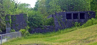
Aqueduct is a hamlet in the Town of Niskayuna, Schenectady County, New York, United States. Its center is at the south end of the bridge of New York State Route 146 over the Mohawk River, that connects Schenectady County to the south and Saratoga County to the north. It was formerly a transportation hub. Alexander's Bridge across the Mohawk antedated the Aqueduct. A new Route 146 steel highway bridge, with board pavement, parallel to the Aqueduct was built in the early 20th century. A Schenectady trolley line ended there, the line also serving Luna Park, just over the river in Rexford. There was, in Aqueduct, a staffed station of the Troy & Schenectady Railroad, which operated from 1841 to 1932.
