Lakes to Locks Passage

Last updated
NYSDOT NYM18-3.svg MTQ Route du Richelieu.svg
Lakes to Locks Passage
Route du Richelieu (Quebec segment)
Lakes to Locks Passage
Lakes to Locks Passage highlighted in red, Route du Richelieu in blue
Route information
Existed2002 (US); 2012 (Quebec)–present
Highway route
South end Waterford, New York
North end Sorel-Tracy, Quebec
Waterway route
South end Cohoes, New York
North end Sorel-Tracy, Quebec
Location
CountriesUnited States, Canada
Provinces Québec
States New York
Highway system
Scenic highways

The Lakes to Locks Passage in the United States and the corresponding Route du Richelieu in Canada form a scenic byway network located in northeastern New York and southern Quebec. This byway connects a series of water routes including the upper Hudson River, Champlain Canal, Lake George, and Lake Champlain. This network is part of a historically significant transportation route linking upstate New York with the Canadian province of Quebec.

Contents

In the United States, the Lakes to Locks Passage is designated as a New York State Scenic Byway, a National Scenic Byway, and an All-American Road. The Canadian portion, known as Route du Richelieu, is recognized by the Quebec Ministry of Tourism as a tourist route.

The Lakes to Locks Passage and Route du Richelieu initiatives aim to promote and integrate these routes as a unified travel destination.

Route description

The Lakes to Locks Passage extends from just north of Albany to near the Canada–US border at Rouses Point in New York. The route includes both a highway and a waterway, with the waterway continuing north into Canada and connecting with the St. Lawrence River.

The region's history is reflected in the diverse influences of French, English, and Dutch settlers, which can be seen in the architecture and cultural heritage of the communities along the rivers, waterfalls, and lakeshores. Along the byway, 32 designated Waypoint Communities offer various local attractions and services. These communities have established museums and other points of interest that function as Heritage Centers for the Lakes to Locks Passage. Additionally, many communities provide options for driving, biking, or walking tours to explore the area.

Highway

NY 9B near Rouse Point NY 9B north in Rouses Point.jpg
NY 9B near Rouse Point
Northern terminus in the United States Lakes to Locks Passage northern terminus US11 north terminus US2 west terminus.jpg
Northern terminus in the United States

The Lakes to Locks Passage extends from the junction of U.S. Route 4 (US 4) and New York State Route 32 (NY 32) in Waterford, New York, to the intersection of U.S. Route 11 (US 11) and New York State Route 9B (NY 9B) in Rouses Point, New York. The route includes both highway and waterway sections. The waterway route continues into Canada and connects with the St. Lawrence River. [1]

The route includes the following segments:

The Lakes to Locks Passage also includes scenic lakeside roads on Point Au Roche and Cumberland Head, which are noted as "Scenic Byways."

A border crossing between Rouses Point, New York, and Lacolle, Quebec, is managed by U.S. Customs and Border Protection and Canada Border Services Agency, facilitating travel between the Lakes to Locks Passage and the Route du Richelieu in Canada.

In Quebec, the Route du Richelieu extends from Lacolle, turning east along Route 202. It branches along both banks of the Richelieu River, reaching its terminus at Sorel-Tracy. [2] The Route du Richelieu has two main branches:

Roundabout in front of Chambly Town Hall, along the Route du Richelieu Rond-point devant la Mairie de Chambly (Quebec), Canada.jpg
Roundabout in front of Chambly Town Hall, along the Route du Richelieu

Bridges over the Richelieu River in Saint-Jean-sur-Richelieu, Chambly, and Beloeil connect the two branches. The branches converge at the northern terminus at the Sorel-Tracy Heritage Interpretation Centre on the Saint Lawrence River.

Waterway

The waterway route extends from the Erie Canal at Cohoes, New York, approximately 9 miles north of Albany and 1 mile southwest of Waterford, to the St. Lawrence River at Sorel-Tracy, Quebec, about 40 miles northeast of Montreal. This waterway constitutes one of North America's earliest interconnected water systems, playing a significant role in the historical development of the United States and Canada. It connects various historic, natural, cultural, and recreational sites along its route, including:

Notable attractions

Quebec along Route du Richelieu

New York State along Lakes to Locks Passage

History

In 1992, the State of New York designated the Champlain Trail as a New York State Scenic Byway, recognizing its significance in providing access to the scenic, historic, cultural, natural, and recreational resources of Lake Champlain and its surrounding communities. In January 2000, local communities in Clinton, Essex, and Washington counties completed a Corridor Management Plan (CMP) for the Champlain Trail. This CMP was part of a broader initiative for Lake Champlain Byways, which involved collaboration with communities in Vermont. Similarly, communities along the Champlain Canal in New York completed a CMP for the Champlain Canal Byway in early 2000. In May 2000, the New York State Scenic Byways Advisory Board (NYSSBAB) adopted these plans and recommended merging the Champlain Canal Byway and the Champlain Trail into a single management organization.[ citation needed ]

In 2002, the Lakes to Locks Passage was designated as an All-American Road by the United States Department of Transportation. This designation acknowledges the byway's historical and recreational significance. As an All-American Road, it is promoted by the Federal Highway Administration as a notable destination.

The byway is managed by Lakes to Locks Passage, Inc., a non-profit organization focused on the preservation and promotion of the natural, cultural, recreational, and historical resources along the upper Hudson River, Champlain Canal, Lake George, and Lake Champlain.

At the 2005 Quebec-New York Economic Summit, Lakes to Locks Passage Inc. and the Regional Conference of Elected Officers (CRÉ) of the Montérégie-Est region signed a memorandum of understanding to collaboratively promote the region and develop travel routes within the Quebec-New York Corridor. [3]

In Quebec, discussions about a tourist route along the Richelieu River began in the mid-1990s. The Route du Richelieu was announced by the CRÉ in March 2010 after receiving approval from the Quebec Ministry of Tourism in 2009. [4] The route was officially inaugurated by CRÉ and Tourisme Montérégie in July 2012. [5]

See also

Related Research Articles

<span class="mw-page-title-main">Saint-Jean-sur-Richelieu</span> City in Quebec, Canada

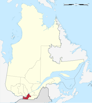
Saint-Jean-sur-Richelieu is a city in eastern Montérégie in the Canadian province of Quebec, about 40 kilometres (25 mi) southeast of Montreal, located roughly halfway between Montreal and the Canada–United States border with the state of Vermont. It is situated on both the west and east banks of the Richelieu River at the northernmost navigable point of Lake Champlain. As of December 2019, the population of Saint-Jean-sur-Richelieu was 98,036.

<span class="mw-page-title-main">Richelieu River</span> River in Quebec, Canada; right tributary of the St. Lawrence

The Richelieu River is a river of Quebec, Canada, and a major right-bank tributary of the St. Lawrence River. It rises at Lake Champlain, from which it flows northward through Quebec and empties into the St. Lawrence. It was formerly known by the French as the Iroquois River and the Chambly River, and was named for Cardinal Richelieu, the powerful minister under Louis XIII.

<span class="mw-page-title-main">La Vallée-du-Richelieu Regional County Municipality</span> Regional county municipality in Quebec, Canada

La Vallée-du-Richelieu(The Valley of the Richelieu) is a regional county municipality in the Montérégie region in southwestern Quebec, Canada. Its seat is McMasterville.

<span class="mw-page-title-main">Chambly, Quebec</span> City in Quebec, Canada

Chambly is an off-island suburb of Montreal in southwestern Quebec, Canada. It is located in the Montérégie region, inland from the South Shore of the Saint Lawrence River.

<span class="mw-page-title-main">Champlain Valley</span> Region of the United States around Lake Champlain

The Champlain Valley is a region of the United States around Lake Champlain in Vermont and New York extending north slightly into Quebec, Canada. It is part of the St. Lawrence River drainage basin, drained northward by the Richelieu River into the St. Lawrence at Sorel-Tracy, Quebec. The Richelieu valley is not generally referred to as part of the Champlain Valley.

<span class="mw-page-title-main">Montérégie</span> Administrative region in Quebec, Canada

Montérégie is an administrative region in the southwest part of Quebec. It includes the cities of Boucherville, Brossard, Châteauguay, Longueuil, Saint-Hyacinthe, Saint-Jean-sur-Richelieu, Salaberry-de-Valleyfield and Vaudreuil-Dorion.

<span class="mw-page-title-main">Chambly Canal</span> Historic canal in Montérégie, Québec

The Chambly Canal is a National Historic Site of Canada in the Province of Quebec, running along the Richelieu River past Saint-Jean-sur-Richelieu, Carignan, and Chambly. Building commenced in 1831 and the canal opened in 1843. It served as a major commercial route during a time of heightened trade between the United States and Canada. Trade dwindled after World War I, and as of the 1970s, traffic has been replaced by recreational vessels.

<span class="mw-page-title-main">Quebec Route 132</span> Highway in Quebec

Route 132 is the longest highway in Quebec. It follows the south shore of the Saint Lawrence River from the border with the state of New York in the hamlet of Dundee, west of Montreal to the Gulf of Saint Lawrence and circles the Gaspé Peninsula. This highway is known as the Navigator's Route. It passes through the Montérégie, Centre-du-Québec, Chaudière-Appalaches, Bas-Saint-Laurent and Gaspésie regions of the province.

<span class="mw-page-title-main">Quebec Route 223</span> Provincial highway in Quebec

Route 223 is a 128.6 km north/south highway on the south shore of the Richelieu River in Quebec. Its northern terminus is in Sorel-Tracy at the junction of Route 132 and its southern terminus is close to Lacolle, where it crosses the U.S. border at the Rouses Point–Lacolle 223 Border Crossing and continues into New York state as U.S. Route 11.

<span class="mw-page-title-main">South Shore (Montreal)</span> Place in Quebec, Canada

The South Shore is the general term for the suburbs of Montreal, Quebec located on the southern shore of the Saint Lawrence River opposite the Island of Montreal. The South Shore is located within the Quebec administrative region of Montérégie.

<span class="mw-page-title-main">Riverside School Board</span>

The Riverside School Board is an English-language school board in the province of Quebec and provides educational services and programs to all students who have a certificate of eligibility for English education in Quebec. They are responsible for anglophone public schools on South Shore (Montreal). Riverside consistently places among the top five and has one of the lowest dropout rates of the 72 public school boards in Quebec, both English and French. It is the birthplace of the French immersion program and offers the International Baccalaureate program in many of their elementary and high Schools.

<span class="mw-page-title-main">Fort Richelieu</span>

Fort Richelieu is a historic fort in La Vallée-du-Richelieu Regional County Municipality, Quebec, Canada. The fort is designated as a National Historic Site of Canada. Fort Richelieu was part of a series of five forts built along the Richelieu River and is at the mouth of the Richelieu River. Fort Chambly formerly known as Fort St. Louis at Chambly, Fort Sainte-Thérèse, and Fort Saint-Jean at Saint-Jean-sur-Richelieu, are on the way. Fort Sainte Anne (Vermont) on Isle La Motte, Vermont in Lake Champlain is near its source. The forts were built in order to protect travellers on the river from the Iroquois. The region is informally known as la Vallée-des-Forts.

<span class="mw-page-title-main">Mohawk Towpath Scenic Byway</span>

The Mohawk Towpath Scenic Byway is a National Scenic Byway in the Capital District region of New York in the United States. It extends from Schenectady to Waterford by way of a series of local, county, and state highways along the Mohawk River and the Erie Canal. The byway is intended to showcase the history of the waterway, from Native American times through the creation of the Erie Canal and the role the waterside communities played in the Industrial Revolution and the westward expansion of the United States. At its east end, the byway connects to the Lakes to Locks Passage, an All-American Road.

<span class="mw-page-title-main">Saint-Mathias-sur-Richelieu</span> Municipality in Quebec, Canada

Saint-Mathias-sur-Richelieu is a municipality in the Canadian province of Quebec. It is located within the Rouville Regional County Municipality in the Montérégie region on the Richelieu River. The population as of the Canada 2021 Census was 4,544.

<span class="mw-page-title-main">Saint-Joseph-de-Sorel</span> City in Quebec, Canada

Saint-Joseph-de-Sorel is a town in the Regional county municipality of Pierre-De Saurel, in Montérégie, Quebec. It is located north of the Tracy section of Sorel-Tracy. Champlain Street marks the town's southern limit from Sorel-Tracy, and the rest of the town is surrounded by water.

<span class="mw-page-title-main">Fort Sainte Thérèse</span> 17th century French fort in Quebec

Fort Sainte Thérèse is the name given to three different forts built successively on one site, among a series of fortifications constructed during the 17th century by France along the Richelieu River, in the province of Quebec, in Montérégie.

<span class="mw-page-title-main">Lake Champlain Seaway</span>

The Lake Champlain Seaway was a canal project proposed in the late 19th century and considered as late as the 1960s to connect New York State's Hudson River and Quebec's St. Lawrence River with a deep-water canal. The objective was to allow easy ship traffic from New York City to Montreal through Lake Champlain, lowering transportation costs between the two cities.

<span class="mw-page-title-main">Chambly Basin</span> Body of water in Montérégie, Quebec

The Chambly Basin is a shallow, oblong body of water formed by an enlargement of the Richelieu River, extending out from the foot of the rapids on the river between Chambly and Richelieu, in the Quebec region of Montérégie. The towns of Chambly, Richelieu, Saint-Mathias-sur-Richelieu and Carignan surround the basin.

<span class="mw-page-title-main">Acadia River</span> River in Canada

The Acadia River flows Northerly over 82 km through seven municipalities in the MRC La Vallée-du-Richelieu, Les Jardins-de-Napierville and Le Haut-Richelieu, in Montérégie, on the South Shore of St. Lawrence river, the Quebec, Canada. The Acadia river empties into the Richelieu River, in Carignan, skirting the city of Chambly by the north.

The Rivière des Iroquois is a tributary of the Richelieu River. It flows in the Saint-Luc sector, of the municipality of Saint-Jean-sur-Richelieu, in the Le Haut-Richelieu Regional County Municipality, in the region administrative of Montérégie, in southern part of the province of Quebec, in Canada.

References

  1. New York State Department of Transportation (January 2012). Official Description of Highway Touring Routes, Bicycling Touring Routes, Scenic Byways, & Commemorative/Memorial Designations in New York State (PDF). Retrieved February 4, 2012.
  2. "About — Route du Richelieu". routedurichelieu.ca. Route du Richelieu. n.d. Retrieved 2020-02-18.
  3. "MOUs AND PROGRESS REPORT AT THE THIRD QUÉBEC-NEW YORK ECONOMIC SUMMIT". ny.gov (in French). ATR de la Montérégie. 2005-10-05. Archived from the original on 2005-11-09.
  4. Archambault, Héloïse (2012). "Lancement prochain de la Route du Richelieu" (in French). L'Oeil Régional.[ dead link ] Alt URL
  5. "La Route du Richelieu est officiellement inaugurée!". tourisme-monteregie.qc.ca (in French). ATR de la Montérégie. 2012-07-04. Archived from the original on 2012-07-19.