The Arctic Archipelago, also known as the Canadian Arctic Archipelago, is a group of islands north of the Canadian mainland.

Upper Normandy is a former administrative region of France. On 1 January 2016, Upper and Lower Normandy merged becoming one region called Normandy.

Koszalin Voivodeship (2) – a unit of administrative division and local government in Poland in the years 1975–98, superseded by West Pomeranian Voivodeship.
The Battle of Meissen was an Austrian victory over a larger Prussian army during the Third Silesian War. An Austrian force under the command of general Beck assaulted 3,500 Prussian troops under Diericke at Meissen, overwhelming them and driving the survivors across the Elbe. The Prussians lost 400 men in the action and 1,543 fell prisoner. Austrian losses were few, totalling only 72 killed and 115 wounded. The Austrians secured an important victory, which effectively kept their ally Saxony in the war.

The Madinah Region is a region of Saudi Arabia, located on the country's west side, along the Red Sea coast. It has an area of 151,990 km² and a population of 2,132,679, subdivided into seven governorates (muḥafaẓat):

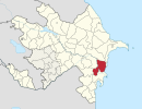
Jabrayil (Cəbrayıl) is de jure an administrative territorial entity in the south-western part of the Republic of Azerbaijan, but de facto this territory was occupied by Armenian forces during the Nagorno-Karabakh War and has been controlled by the unrecognized Republic of Artsakh ever since. According to the last 1989 Soviet census, there were 49,156 people living in the rayon. Jabrail rayon has productive soils, and before the war the population was mostly involved in agriculture. Jabrayil shares its southern borders with Iran.

The Balearic Sea is a body of water in the Mediterranean Sea near the Balearic Islands. It is not to be confused with the Alboran Sea or the Iberian shelf waters. The Ebro River flows into this small sea.
Olm is a village in the commune of Kehlen, in western Luxembourg. As of 2007, the village had a population of over 1,500 of whom some 1,200 lived in the Huesekneppchen residential area.

Gottelborn Solar Park is an 8.4-MWp photovoltaic power station located in Göttelborn, in Quierschied municipality, Germany. The power plant was constructed by City Solar in two stages. The first stage was completed in August, 2004, followed by the second stage three years later in November 2007.

Trzcianiec is a village in the administrative district of Gmina Ustrzyki Dolne, within Bieszczady County, Subcarpathian Voivodeship, in south-eastern Poland. It lies approximately 19 kilometres (12 mi) north-west of Ustrzyki Dolne and 62 km (39 mi) south-east of the regional capital Rzeszów.

Garip Island is a small island off the coast of Dikili ilçe in İzmir Province, Turkey. It is one of two small islands, together called the Garip Islands, at the cut point of Dikili's Bademli Bay. Both islands face the Greek island of Lesbos.
The Sack of Mahon occurred in 1535, when Hayreddin Barbarossa attacked the harbour of Mahón in the Balearic Islands.
Ismat Gayibov Stadium, also referred as Bakikhanov Stadium is a multi-use stadium in Bakikhanov settlement of Baku, Azerbaijan. It is named in honor of Ismat Gayibov. It is currently used mostly for football matches. In February 2011, the president of Neftchi Baku football club Sadyg Sadygov announced that in domestic competitions Neftchi will host the rivals in Ismat Gayibov Stadium beginning from 2011-2012 season. The stadium holds approximately 5,000 seats. However, he states that an additional sector with 2,500 seats is to be constructed in the stadium.
Nariman Narimanov Stadium is a multi-purpose stadium in Neftchala, Azerbaijan. It is currently used mostly for football matches and is the home stadium of FK Neftchala. The stadium holds 2,000 seats. The stadium is named after the Azerbaijani Communist statesman Nariman Narimanov.
Jennersville is an unincorporated community located in Penn Township, Chester County, Pennsylvania, United States at latitude 39.823 and longitude -75.87. It is associated for postal purposes with the borough of West Grove, Pennsylvania, and appears on the West Grove U.S. Geological Survey Map.
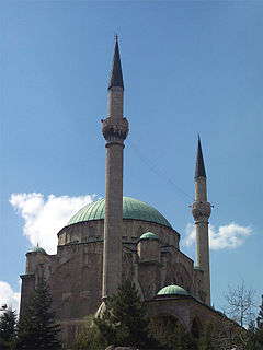
Maltepe Mosque or is a mosque in Ankara, Turkey. Along with Kocatepe Mosque, it is one of the best known mosques in Ankara.