Darwin is a small unincorporated community in central Bedford Township, Meigs County, Ohio, in the United States. It is located along U.S. Route 33 between Athens and Pomeroy, at its intersection with State Route 681.

Urbanice is very small village in the Pardubice Region of the Czech Republic. It has around 73 inhabitants.
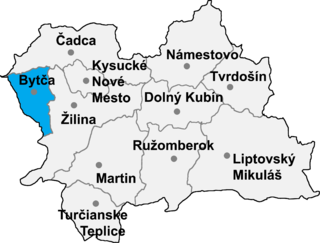
Jablonové is a village and municipality in Bytča District in the Žilina Region of northern Slovakia.

Huty is a village and municipality in Liptovský Mikuláš District in the Žilina Region of northern Slovakia.

Dairut is a city in Egypt. It is located on the west bank of the Nile, in the Asyut Governorate. This is the point where the Nile divides, and a branch wanders off and eventually ends up in the Faiyum.

Noramarg is a town in the Ararat Province of Armenia.

Kurobe Dam Station is a trolleybus station in Tateyama, Nakaniikawa District, Toyama Prefecture, Japan. The station offers views of Kurobe Dam.

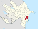
Cuvarlı is a village in the Fizuli Rayon of Azerbaijan.
Cəngan is a village in the Neftchala Rayon of Azerbaijan. The village forms part of the municipality of Ərəbqardaşbəyli.
Axullu is a village in the Khojavend Rayon of Azerbaijan.

Obidowa is a village in the administrative district of Gmina Nowy Targ, within Nowy Targ County, Lesser Poland Voivodeship, in southern Poland. It lies approximately 10 kilometres (6 mi) north of Nowy Targ and 58 km (36 mi) south of the regional capital Kraków.

Glinik is a village in the administrative district of Gmina Wielopole Skrzyńskie, within Ropczyce-Sędziszów County, Subcarpathian Voivodeship, in south-eastern Poland. It lies approximately 5 kilometres (3 mi) north-west of Wielopole Skrzyńskie, 15 km (9 mi) south of Ropczyce, and 33 km (21 mi) west of the regional capital Rzeszów.
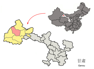
Guazhou County, formerly Anxi County, is a county in the northwest of Gansu province, the People's Republic of China. It is under the administration of Jiuquan City.

Acedera is a Spanish municipality in the province of Badajoz, Extremadura. It has a population of 842 (2007) and an area of 82.5 km².
Olszyc Włościański is a village in the administrative district of Gmina Domanice, within Siedlce County, Masovian Voivodeship, in east-central Poland. It lies approximately 6 kilometres (4 mi) west of Domanice, 20 km (12 mi) south-west of Siedlce, and 79 km (49 mi) east of Warsaw.
Kozłówko is a village in the administrative district of Gmina Trzemeszno, within Gniezno County, Greater Poland Voivodeship, in west-central Poland. It lies approximately 3 kilometres (2 mi) west of Trzemeszno, 13 km (8 mi) east of Gniezno, and 62 km (39 mi) east of the regional capital Poznań.
Węgornia is a village in the administrative district of Gmina Łęczyce, within Wejherowo County, Pomeranian Voivodeship, in northern Poland. It lies approximately 4 kilometres (2 mi) south-west of Łęczyce, 28 km (17 mi) west of Wejherowo, and 57 km (35 mi) north-west of the regional capital Gdańsk.
Yale First Nation is a First Nations government located at Yale, British Columbia. Yale has 16 distinct reserves stretching from near Sawmill Creek to American Creek, with the most southern reserve situated at Ruby Creek in the District of Kent.
Muk is a populated place in Tajikistan.

Rečica is a village in the municipality of Bojnik, Serbia. According to the 2002 census, the village has a population of 148 people.