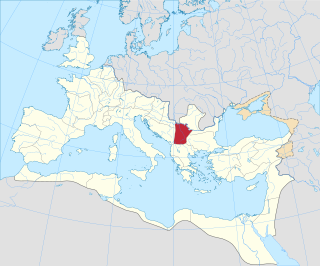
Moesia was an ancient region and later Roman province situated in the Balkans south of the Danube River. Moesian Province was first administered by governor of Noricum as 'Civitates of Moesia and Triballia'. It included most of the territory of modern eastern Serbia, Kosovo, north-eastern Albania, northern parts of North Macedonia, Northern Bulgaria, Romanian Dobruja and small parts of Southern Ukraine.
Lom is a town in northwestern Bulgaria, part of Montana Province, situated on the right bank of the Danube, close to the estuary of the Lom River. It is the administrative centre of the eponymous Lom Municipality. The town is 162 km (101 mi) north of Sofia, 56 km (35 mi) southeast of Vidin, 50 km (31 mi) north of Montana and 42 km (26 mi) west of Kozloduy. It is the second most important Bulgarian port on the Danube after Ruse.
Bulgarian placename etymology is characterized by the linguistic and ethnic diversity of the Balkans through the ages and the position of the country in the centre of the region. While typical Bulgarian placenames of Slavic origin vastly dominate, toponyms which stem from Iranian, Turkic, Arabic, Hebrew, Celtic, Gothic, Greek, Thracian and Latin can also be encountered.

Archar Peninsula located in the North-Western extremity of Greenwich Island, Antarctica. The three km long peninsula is bounded by Razlog Cove to the North and McFarlane Strait to the South. Its western half is snow-free in summer. The peninsula is named after the settlement of Archar in Northwestern Bulgaria, successor of the ancient town of Ratiaria.
Popovo is a town in northeastern Bulgaria, part of Targovishte Province. It is the administrative centre of the homonymous Popovo Municipality. In 2021, it had a population of 13,324 and an absolute Bulgarian majority.

The Danubian Plain constitutes the northern part of Bulgaria, situated north of the Balkan Mountains and south of the Danube. Its western border is the Timok River and to the east it borders the Black Sea. The plain has an area of 31,523 square kilometres (12,171 sq mi). It is about 500 kilometres (310 mi) long and 20 to 120 kilometres wide.

Devnya is a town in Varna Province, Northeastern Bulgaria, located about 25 km away to the west from the city of Varna and The Black Sea Coast. It is the administrative centre of the homonymous Devnya Municipality. As of December 2009, the town has a population of 8,383 inhabitants.

Dacia Ripensis was the name of a Roman province in the northern Balkan peninsula, immediately south of the Middle Danube. Its capital was Ratiaria. It was a district less urban than neighbouring Dacia Mediterranea and more militarized; "military camps and forts, rather than cities, were typical of the province". Besides Ratiaria, Oescus was the major settlement.

Abritus (Abrittus) was an impressive Roman walled city and one of the biggest urban centres in the province of Moesia Inferior. Its remains are in the Archaeological Park of Razgrad.
Ruzhintsi is a village in northwestern Bulgaria, part of Vidin Province. It is the administrative centre of the homonymous Ruzhintsi Municipality, which lies in the southeastern part of Vidin Province. Ruzhintsi is located 54 kilometres from the provincial capital Vidin and 43 kilometres from Montana.
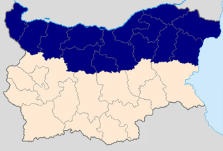
Northern Bulgaria, also called Moesia is the northern half of Bulgaria, located to the north of the main ridge of the Balkan Mountains which conventionally separates the country into a northern and a southern part. Besides the Balkan Mountains, Northern Bulgaria borders the Timok River and Serbia to the west, the Danube River and Romania to the north and the Bulgarian Black Sea Coast to the east.

The Archar or Archaritsa is a river in the western Danubian Plain of northern Bulgaria and a right tributary of the Danube. It originates in the western Balkan Mountains and is around 60 kilometres in length, with a drainage basin of 364 square kilometres. The river runs through limestone terrain and has steep banks, in certain sections up to 100 metres high. The Archar flows into the Danube at the large village of Archar in Dimovo municipality, Vidin Province. It also passes through Rayanovtsi, Rabisha, Kladorub, Ostrokaptsi, Dimovo, Lagoshevtsi and Darzhanitsa.

The Palace of Omurtag or Aul (Aulē) of Omurtag is an archaeological site in northeastern Bulgaria dating to Late Antiquity and the Early Middle Ages located near the village of Han Krum in Shumen Province. The site has been pinpointed as the location of a fort and palace of Omurtag, ruler (kanasybigi) of the First Bulgarian Empire in 815–831, as mentioned in the Chatalar Inscription of 822. Earlier structures in the vicinity of the fortress have been identified as the Arian episcopal see of a Gothic bishop.
Dolni Lom is a village in the municipality of Chuprene, in Vidin Province, in northwestern Bulgaria.
Rabisha is a village in north-western Bulgaria, in Vidin Province and Belogradchik municipality.
Kladorub is a village in northwestern Bulgaria.
Krivnya is a village in northeastern Bulgaria, part of Vetovo Municipality, Ruse Province. Krivnya is picturesquely situated in the valley of the Beli Lom River in the western part of the Ludogorie located in the hilly Danubian Plain (Bulgaria). The village is surrounded by rock formations, among which the river meanders and divides the village into two parts. In the past the river flowed slowly making a big curve and forming a sort of peninsula. In the last century (1959) an artificial correction of the riverbed is made by using of explosions and the rock formation is "cut." Today this place is known as " Prosyakata." The altitude of the area ranges between 100 and 200 meters. Relief, except the rocky formations around the river is favorable for agriculture. The climate is continental with hot summers and cold winters. The village is located 3 km from the Ruse-Varna railway line and between the towns of Vetovo and Senovo, Ruse Province.
The Danubian Limes, or Danube Limes, refers to the Roman military frontier or limes which lies along the River Danube in the present-day German state of Bavaria, in Austria, Slovakia, Hungary, Croatia, Serbia, Bulgaria and Romania.


