
Karmirgyugh is a village in the Gavar Municipality of the Gegharkunik Province of Armenia.
Pemzashen is a village in the Artik Municipality of the Shirak Province of Armenia. During the Soviet era a sewing factory, construction materials plant, and a parts factory to supply hydro-electric stations were based out of Pemzashen. After the collapse of the USSR, most of the village's residents have found themselves out of work and many of the men have moved to Russia to find jobs. In the past 15 years, over 300 families have moved away from the village. There is also the problem of a lack of irrigation water for crops or household gardens, and the land around the village is not flat or fertile. Plans are currently underway to put in an irrigation system.
Amasia is a village in the Armavir Province of Armenia.
Araks, known as Nerkin Karkhun and Sharifabad until 1946, is a village in the eastern part of the Armavir Province of Armenia, specifically in the Araks Municipality.
Baghramyan is a village in the Armavir Province of Armenia. It is named after the Soviet Armenian military commander and Marshal of the Soviet Union Ivan Bagramyan.
Davtashen, known as Aylanlu until 1950, is a village in the Talin Municipality of the Aragatsotn Province of Armenia.
Getap, known until 1946 as Karakula or Gharaghla is a village in the Aragatsavan Municipality of the Aragatsotn Province of Armenia, located near the Armenia–Turkey border.

Gharibjanyan, known as Aleksandrovka until 1935, is a village in the Akhuryan Municipality of the Shirak Province of Armenia. The village was renamed in 1935 in honor of Bolshevik leader Bagrat Gharibjanyan, killed in 1920.
Hovtun is a village in the Amasia Municipality of the Shirak Province of Armenia. The village was originally inhabited by Azerbaijanis, then Greeks, and now Armenians.

Lchap is a village in the Gavar Municipality of the Gegharkunik Province of Armenia.
Lenughi is a village in the Armavir Province of Armenia. The town's church, dedicated to Saint Nshan, dates from the 1870s. The "MAP" brandy and wine factory is located in Lenughi.
Mrgastan is a village in the Armavir Province of Armenia. The town's church, dedicated to Saint Hovhannes, was built in 1912.
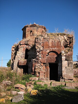
Tsaghkalanj is a village in the Armavir Province of Armenia. The village's church, dedicated to Saint George, dates to the 1870s. It rests on an earlier circular foundation. Nearby, is the whitewashed Amenaprkich Church of an unknown date. There is also a Neolithic-Chalcolithic tell in the village and Bronze Age burial mounds, while the ruins of Amenaprkich, a medieval settlement are nearby.
Tsiatsan is a village in the Armavir Province of Armenia.
Yeghnik, known until 1946 as Dadalu, is a village in the Talin Municipality of the Aragatsotn Province of Armenia. The village's church, Saint Nshan, dates back to 1866.
Yeraskhahun is a village in the Armavir Province of Armenia. Half of the population of the village are Yazidis.

Arevadasht, is a village in the Armavir Province of Armenia.
Talvorik is a village in the Armavir Province of Armenia.

Vanand is a village located in the southwestern portion of the Armavir Province in Armenia, 5 kilometers from the Armenian border with Turkey. The village was founded in 1984 from a sovkhoz, and was an area that was once closed to foreigners. There is a single school, house of culture, community center, kindergarten, and no cultural heritage monuments.
Hoghmik is a village in the Amasia Municipality of the Shirak Province of Armenia.


