Karin, Armenia

Last updated

Coordinates: 40°15′N44°20′E / 40.250°N 44.333°E / 40.250; 44.333

Geographic coordinate system Coordinate system

A geographic coordinate system is a coordinate system that enables every location on Earth to be specified by a set of numbers, letters or symbols. The coordinates are often chosen such that one of the numbers represents a vertical position and two or three of the numbers represent a horizontal position; alternatively, a geographic position may be expressed in a combined three-dimensional Cartesian vector. A common choice of coordinates is latitude, longitude and elevation. To specify a location on a plane requires a map projection.

Karin
Կարին
Armenia adm location map.svg
Red pog.svg
Karin
Coordinates: 40°15′N44°20′E / 40.250°N 44.333°E / 40.250; 44.333
Country Armenia
Marz (Province) Aragatsotn
Population (2001)
  Total 334
Time zone   (UTC+4)
  Summer (DST)  (UTC)

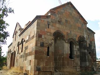
Karin (Armenian : Կարին), is a village in the Aragatsotn Province of Armenia. The village is part of the community of Sasunik.

Armenian language Indo-European language

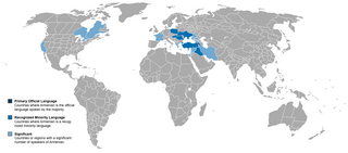
The Armenian language is an Indo-European language spoken primarily by Armenians. It is the official language of Armenia. Historically being spoken throughout the Armenian Highlands, today, Armenian is widely spoken throughout the Armenian diaspora. Armenian is written in its own writing system, the Armenian alphabet, introduced in 405 AD by Mesrop Mashtots.

Aragatsotn Province Province in Armenia

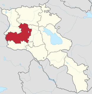
Aragatsotn is a province (marz) of Armenia. It is located in the western part of the country. The capital and largest city of the province is the town of Ashtarak. The National Statistical Service of the Republic of Armenia (ARMSTAT) reported its population was 132,925 in the 2011 census.

Sasunik Place in Aragatsotn, Armenia

Sasunik ; is a village in the Aragatsotn Province of Armenia. It was founded as a collective farm in 1955, and villagers were resettled from the old village of Sasunik in 1960. The community of Sasunik also includes the village of Karin.

See also

Related Research Articles

Voskevaz Place in Aragatsotn, Armenia

Voskevaz is a village in the Aragatsotn province of Armenia. Not far from the center of the village is the church of Surp Hovhannes, built between the 7th and 12th centuries. The village is home to the Hayasy brewery.

Alagyaz Place in Aragatsotn Province, Armenia

Alagyaz is a village in the Aragatsotn Province of Armenia. Most of the population are Yazidis and Kurds.

Apnagyugh Place in Aragatsotn, Armenia

Apnagyugh ; formerly known as Akina-Gök, is a village in the Aragatsotn Province of Armenia.

Aragats, Aragatsotn Place in Aragatsotn, Armenia

Aragats ; known as Ghaznafar until 1948, is a village in the eastern part of the Aragatsotn Province of Armenia.

Aragatsotn (village) Place in Aragatsotn, Armenia

Aragatsotn is a village in the Aragatsotn Province of Armenia. Aragatsotn was a former sovkhoz, founded in 1971.

Arayi Place in Aragatsotn, Armenia

Arayi ; formerly known as Bazarjik and Ara, is a village in the Aragatsotn Province of Armenia. It is home to a ruined caravanserai dating back to 1213.

Arum, Armenia Place in Aragatsotn, Armenia

Arum, is an abandoned village in the Aragatsotn Province of Armenia.

Otevan Place in Aragatsotn, Armenia

Otevan ; formerly known as Bashsis and Baysuz is a village in the Aragatsotn Province of Armenia. The village is home to a 12th-century ruined Armenian church as well as the ruins of a fortress. The town is mostly populated by Yezidis.

Charchakis Place in Aragatsotn, Armenia

Charchakis ; is a village in the Aragatsotn Province of Armenia. It was originally known as Charchakes and Jarjaris. Between 1978 and 2006 the village was known as Derek. It is home to a ruined church dating back to the 5th century.

Lernapar Place in Aragatsotn, Armenia

Lernapar is a small village in the Aragatsotn Province of Armenia.

Kayk, Armenia Place in Aragatsotn, Armenia

Kayk, formerly known as Melkon-kend and Mulki, is a village in the Aragatsotn Province of Armenia.

Shoghakn Place in Aragatsotn, Armenia

Shoghakn is a village in the Aragatsotn Province of Armenia. It used to be known as Sachlu and was renamed Norashen between 1946 and 2006.

Norashen, Aragatsotn Place in Aragatsotn, Armenia

Norashen ; known as Sachlu until 1946, is a village in the western part of the Aragatsotn Province of Armenia.

Mijnatun Place in Aragatsotn Province, Armenia

Mijnatun ; formerly known as Ortachya, is a village in the Aragatsotn Province of Armenia. It is mostly populated by Yazidis.

Shamiram, Armenia Place in Aragatsotn, Armenia

Shamiram, is a village in the Aragatsotn Province of Armenia. It is mostly populated by Yazidis.

Tsilkar Place in Aragatsotn, Armenia

Tsilkar is a village in the Aragatsotn Province of Armenia.

Ttujur, Aragatsotn Place in Aragatsotn, Armenia

Ttujur is a village in the Aragatsotn Province of Armenia. The village 's church is dedicated to Saint Harutyun. The village also contains a 17th-century shrine called "Karmir Vank".

Partizak Place in Aragatsotn, Armenia

Partizak, is a village in the Aragatsotn Province of Armenia.

Verin Sasunik Place in Aragatsotn, Armenia

Verin Sasunik ; formerly known as Gharajilar, is a village in the Aragatsotn Province of Armenia. It was depopulated in 1960 and resettled in 1989.

Khnusik Place in Aragatsotn, Armenia

Khnusik, is a village in the Aragatsotn Province of Armenia. It is part of the Avan community.

References

National Statistical Service of Republic of Armenia is the national statistical agency of Armenia.