Coordinates: 40°17′35″N44°03′16″E / 40.29306°N 44.05444°E
A geographic coordinate system is a coordinate system that enables every location on Earth to be specified by a set of numbers, letters or symbols. The coordinates are often chosen such that one of the numbers represents a vertical position and two or three of the numbers represent a horizontal position; alternatively, a geographic position may be expressed in a combined three-dimensional Cartesian vector. A common choice of coordinates is latitude, longitude and elevation. To specify a location on a plane requires a map projection.
Arum | |
---|---|
Coordinates: 40°17′26″N44°04′11″E / 40.29056°N 44.06972°E | |
Country | Armenia |
Marz (Province) | Aragatsotn |
Time zone | (UTC+4) |
Arum, is an abandoned village in the Aragatsotn Province of Armenia.
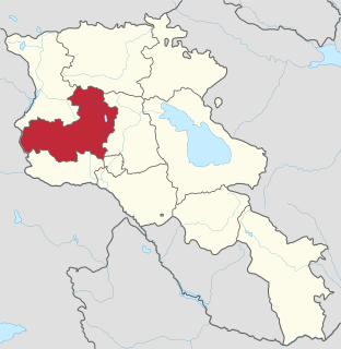
Aragatsotn is a province (marz) of Armenia. It is located in the western part of the country. The capital and largest city of the province is the town of Ashtarak. The National Statistical Service of the Republic of Armenia (ARMSTAT) reported its population was 132,925 in the 2011 census.
Armenia, officially the Republic of Armenia, is a country in the South Caucasus region of Eurasia. Located in Western Asia on the Armenian Highlands, it is bordered by Turkey to the west, Georgia to the north, the de facto independent Republic of Artsakh and Azerbaijan to the east, and Iran and Azerbaijan's exclave of Nakhchivan to the south.
Antarut is a town in the Aragatsotn Province of Armenia. The town contains ancient khachkars.
Apnagyugh ; formerly known as Akina-Gök, is a village in the Aragatsotn Province of Armenia.
Aragats ; known as Ghaznafar until 1948, is a village in the eastern part of the Aragatsotn Province of Armenia.
Aragatsotn is a village in the Aragatsotn Province of Armenia. Aragatsotn was a former sovkhoz, founded in 1971.
Arayi ; formerly known as Bazarjik and Ara, is a village in the Aragatsotn Province of Armenia. It is home to a ruined caravanserai dating back to 1213.
Chknagh is a town in the Aragatsotn Province of Armenia.
Dian is a town in the Aragatsotn Province of Armenia.
Geghadir is a town in the Aragatsotn Province of Armenia.
Hnaberd is a town in the Aragatsotn Province of Armenia. The town has a 5th-century church. There is a large Urartian fortress nearby.
Kakavadzor is a town in the Aragatsotn Province of Armenia.
Lernarot is a town in the Aragatsotn Province of Armenia. It had a population of 430 in 2009/ 2009.
Kayk, formerly known as Melkon-kend and Mulki, is a village in the Aragatsotn Province of Armenia.
Norashen ; known as Sachlu until 1946, is a village in the western part of the Aragatsotn Province of Armenia.
Mijnatun ; formerly known as Ortachya, is a village in the Aragatsotn Province of Armenia. It is mostly populated by Yazidis.
Saralanj is a town in the Aragatsotn Province of Armenia.
Tsaghkashen is a town in the Aragatsotn Province of Armenia.
Tsilkar is a village in the Aragatsotn Province of Armenia.
Ttujur is a village in the Aragatsotn Province of Armenia. The village 's church is dedicated to Saint Harutyun. The village also contains a 17th-century shrine called "Karmir Vank".
Vardablur is a town in the Aragatsotn Province of Armenia.
Vardenis is a town in the Aragatsotn Province of Armenia. The town has a 19th-century church.
This article about a location in Aragatsotn Province, Armenia is a stub. You can help Wikipedia by expanding it. |