Garni, is a major village in the Kotayk Province of Armenia. It is known for the nearby classical temple. As of the 2011 census, the population of the village is 6,910.
Oshakan is a major village in the Aragatsotn Province of Armenia located 8 kilometers southwest from Ashtarak. It is well known to historians and pilgrims of the Armenian Apostolic Church as the site of the grave of Mesrop Mashtots, the inventor of the Armenian alphabet.

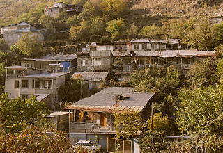
Bjni, is a village in the Kotayk Province of Armenia. It is situated in a valley between canyon walls and a small river. The village is one of the prominent centers of education and culture of ancient and medieval Armenia. It is the birthplace of the 11th-century scholar Grigor Magistros.
Karmravor, also known as the Church of Holy Mother of God is a 7th-century Armenian Apostolic church in the town of Ashtarak in the Aragatsotn Province.

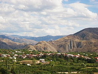
Arzakan, is a village in the Kotayk Province of Armenia. The Aghveran resort is located in Arzakan. There are the large ruins of the 10th- or 11th-century Neghutsi Vank, located along a ravine to the northwest of the village. There are also the 13th-century monastic ruins of Ghuki Vank and 13th-century ruins of Surb Gevorg in the vicinity.

Tsaghkalanj is a village in the Armavir Province of Armenia. The village's church, dedicated to Saint George, dates to the 1870s. It rests on an earlier circular foundation. Nearby, is the whitewashed Amenaprkich Church of an unknown date. There is also a Neolithic-Chalcolithic tell in the village and Bronze Age burial mounds, while the ruins of Amenaprkich, a medieval settlement are nearby.
Yeghipatrush, is a village in the Aragatsotn Province of Armenia. During the Soviet period, the town was renamed in honor of Askanaz Mravyan, Soviet Armenian Cultural Commissar. The town has a 10th- to 13th-century church of Surb Astvatsatsin. Some 100 meters beyond the church is an early cemetery with one corner of an allegedly 5th-century basilica as well as a khachkar shrine.
Avan is a village in the Aragatsotn Province of Armenia. The population of the village is mainly Armenian. It is home to the basilica-style church of Surb Astvatsatsin that sits along a street just off the main road beside the main cemetery. The large cemetery contains many khachkars from the 13th to 18th centuries. Adjacent to it across the street is a stepped plinth and broken funerary pillar monument of the 5th to 6th centuries. A worn inscription may be found along the landings of the second and third steps. There is a newly built church also by the name of Surb Astvatsatsin that sits near the main highway closer to the centre of the village, and is said to have been constructed upon old foundations. Some confusion may arise since two churches in the village are referred to as S. Astvatsatsin, but one of them may be the church of S. Hovhannes. They are said to have been first built in the 5th to 6th centuries, were reconstructed in the 13th century, and have sat in ruins until recently since the earthquake of 1679.

Zar is a village in the Kalbajar Rayon of Azerbaijan, currently under the control of the unrecognized Republic of Artsakh.

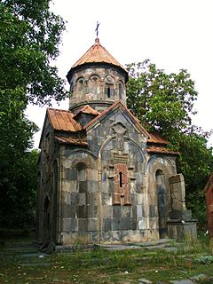
Zoravor Surp Astvatsatsin Church is the oldest surviving church in Yerevan. It was previously known as Surp Astvatsatsin. However, the name Zoravor was added because the church was home to the 13th century bible of Zoravor.
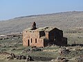
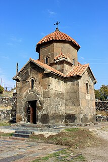
Mashtots Hayrapet is a church located within the village of Garni in the Kotayk Province of Armenia. It was built in the 12th century at the site of what was a pagan shrine. A stone carved from red tufa is situated at the right of the entrance upon a low rock wall. It has on it the design of a bird perched on a floral stem with the rosette of eternity under its tail. The rosette is also a distinctive pagan symbol representing the sun or the moon, symbolizing the eternal cycle of life, death, and rebirth. It is said that because of this pagan symbology, this stone has a connection to the prior shrine.
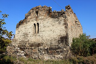
Spitakavor Church ; literally meaning white-colored church, is a 13th-century partly ruined Armenia church located at the edge of a gorge in the town of Ashtarak, Aragatsotn Province, Armenia.
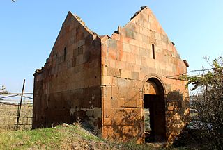
Tsiranavor Church ; literally meaning apricot-colored church is a 5th-century partly ruined Armenian church located at the edge of a gorge in the town of Ashtarak, Aragatsotn Province, Armenia.

Geghardavank or Krtsanis Tsiranavor Surp Astvatsatsin is a 13th-century Armenian church in Old Tbilisi, Georgia. It was founded in the 13th century. Currently it is not functioning as a church.

Saint Mary Church, Holy Mother of God Church or Surp Mariam Asdvadzadzin Church is an Armenian Apostolic church in Tabriz, East Azerbaijan Province, Iran completed in 1785. It is the largest and oldest Christian church in Tabriz and a notable centre for Armenian national and religious ceremonies held by the Armenian community of Tabriz.

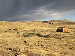
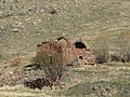
Neghuts Monastery is a monastery founded in the 10th or 11th century, situated in a clearing on a hillside overlooking a valley and the village of Arzakan in the Kotayk Province of Armenia. The monastery is located approximately 2 kilometres (1.2 mi) northwest of the village center. There are other churches in the vicinity, most notably the 13th-century monastic/church ruins of Ghuki Vank, the church ruins of S. Astvatsatsin (1207), and the 13th-century ruins of Surb Gevorg.
Saint or Surp Astvatsatsin Church may refer to:

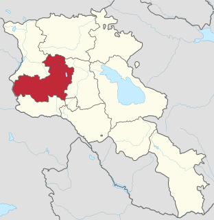
Diocese of Aragatsotn, is a diocese of the Armenian Apostolic Church covering the Aragatsotn Province of Armenia. The name is derived from the historic Aragatsotn canton of Ayrarat province of Kingdom of Armenia.

Church of the Holy Virgin or Holy Mother of God Church was an Armenian Apostolic church in the Old City (İçərişəhər) of Baku, Azerbaijan, built in the 18th century and demolished in 1992. It was on the southern side of the Maiden Tower at the turn of Neftyanikov Avenue between the caravansary, Barbara Street and Great Minaret Street.