Arizona State Route 92

Last updated

Arizona 92.svg

State Route 92

Arizona State Route 92
SR 92 highlighted in red
Route information
Maintained by ADOT
Length33.91 mi [1]  (54.57 km)
Major junctions
West endArizona 90.svg SR 90 near Sierra Vista
East endArizona 80.svg SR 80 in Bisbee
Location
Country United States
State Arizona
Highway system
  • Arizona State Highway System
US 91 1963 (AZ).svg US 91 Arizona 93.svg SR 93

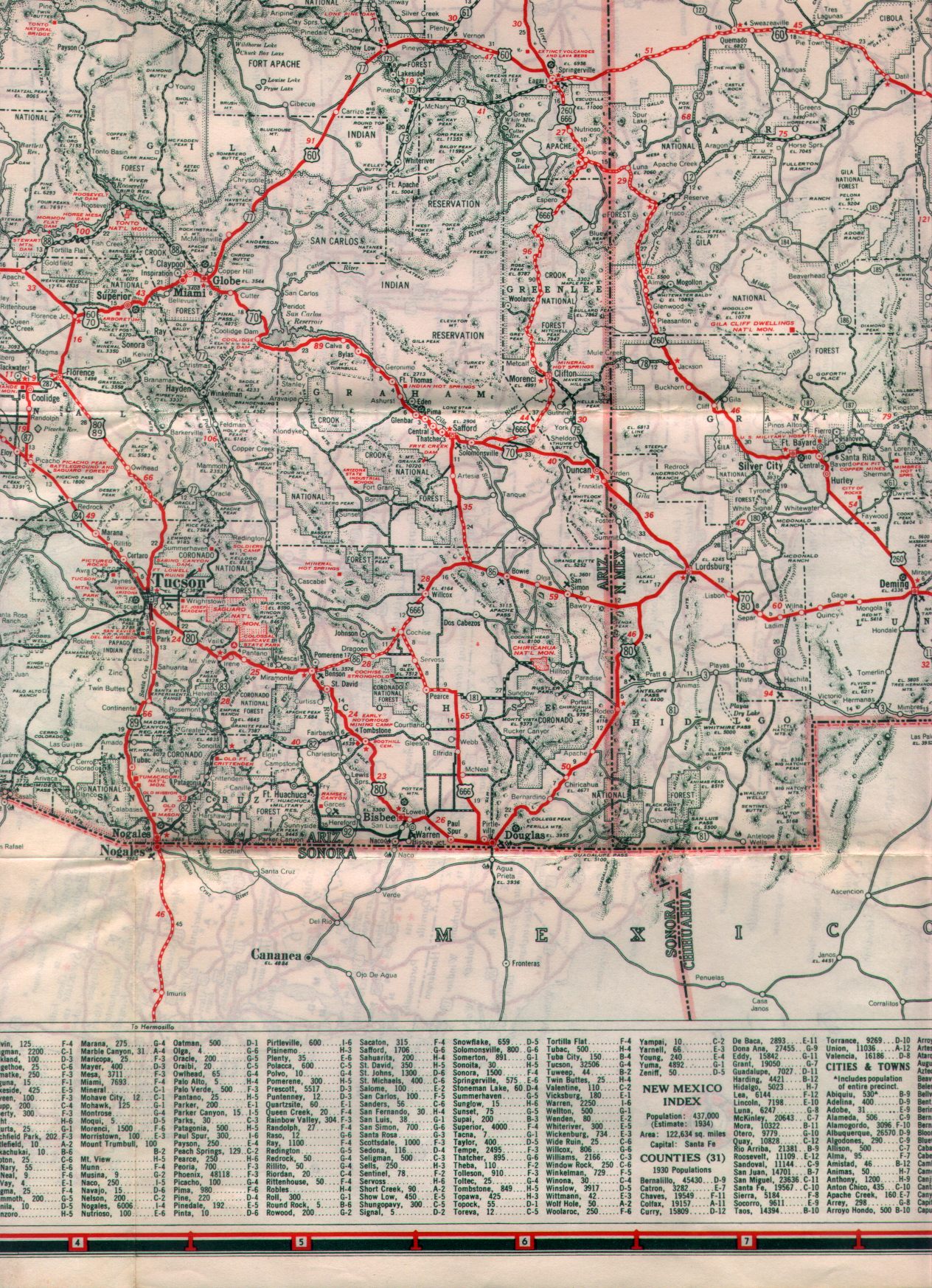
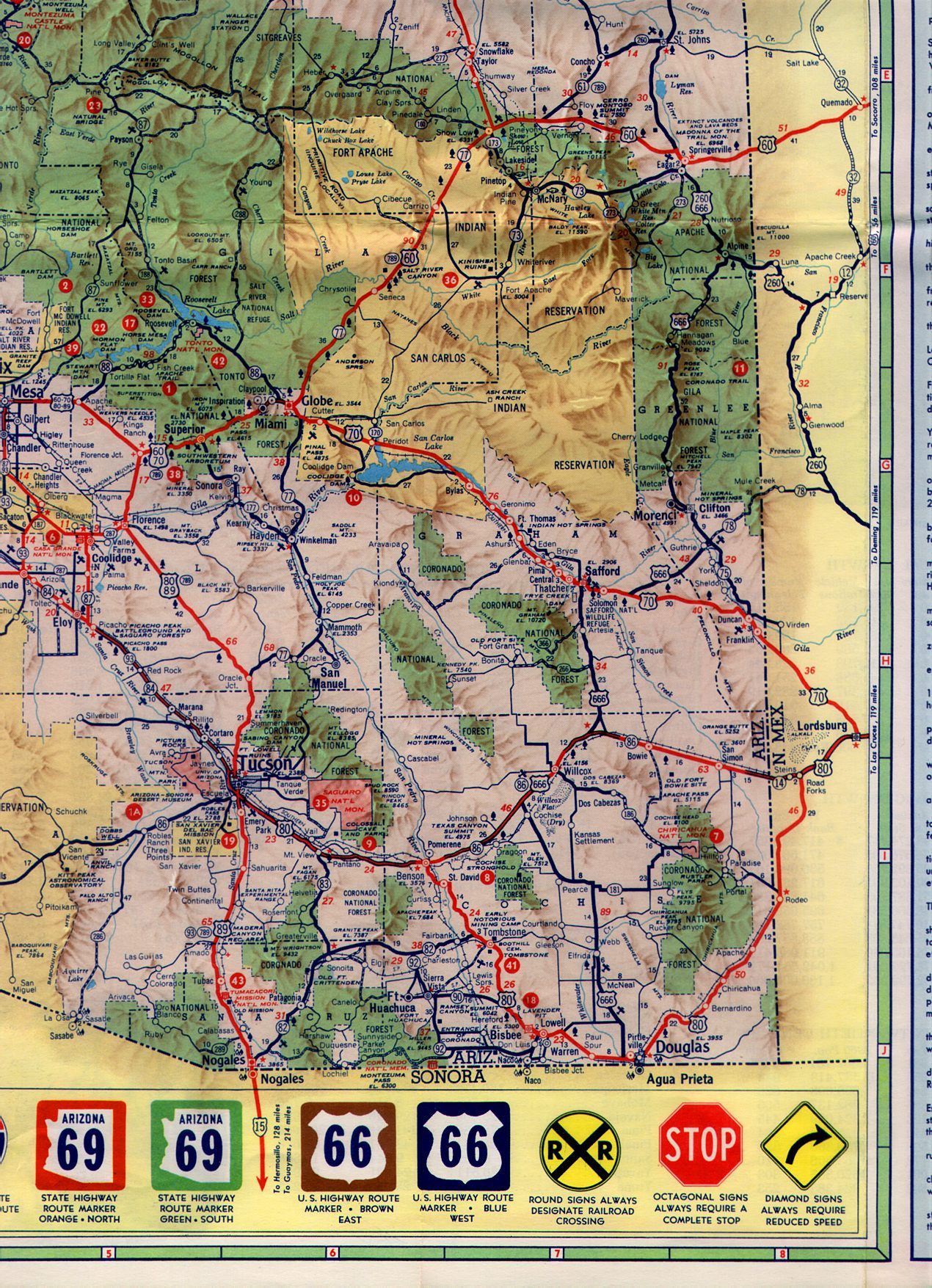
State Route 92 (SR 92) is a state highway in the U.S. state of Arizona. Running roughly in an L-shaped pattern, SR 92 begins at SR 90 in Sierra Vista and ends at a traffic circle in Bisbee along SR 80, running entirely within Cochise County. The route was constructed and numbered as SR 92 in the late 1930s with a route that traveled further north past Sierra Vista than it does today. The routing was corrected in the 1960s.

Contents

Route description

SR 92 begins at an intersection with Fry Boulevard in Sierra Vista. SR 90 is the designation along the roads heading north and east from the intersection. From here, SR 92 heads south through Sierra Vista, passing by residential areas in a desert terrain. The road then passes through the town of Nicksville in Sierra Vista Southeast while the west side of the route is flanked by the Coronado National Forest, in which Huachuca Mountains are located. SR 92 then turns eastward, passing within several miles within the Mexico–United States border. The route passes the towns of Miracle Valley and Palominas before turning northeast. The roadway enters the town of Bisbee, meeting its terminus at a traffic circle in the city. [2]

The highway is maintained by the Arizona Department of Transportation (ADOT), which is responsible for maintaining SR 92 like all other highways around the state. As part of this role, ADOT periodically surveys traffic along its routes. These surveys are most often presented in the form of average annual daily traffic, which is the number of vehicles who use the route on any average day during the year. In 2009, ADOT calculated that around as few as 3,700 vehicles used the route daily near Palominas and as many as 31,000 daily near the northern terminus at Sierra Vista. [3] No part of the highway has been listed in the National Highway System, [4] a system of roads in the United States important to the nation's economy, defense, and mobility. [5]

History

The highway was designated in 1936, originating at SR 82 in Whetstone and heading south into Sierra Vista. From there, it turned east for a stretch and then turned south following its current route to Bisbee. [6] [7] At this time, the section of the route corresponding to the current routing was paved, while the northern section was still a gravel road. [7] The northern section was improved in 1942. [8] [9] In 1961, SR 90 took over the segment of SR 92 north of Sierra Vista, leaving SR 92 to the section south of the city and east to Bisbee. [10] [11] Since then, the routing has not been modified. [2]

Junction list

The entire route is in Cochise County.

Locationmi [1] kmDestinationsNotes
Sierra Vista 0.000.00Arizona 90.svg SR 90  Benson, Bisbee
Bisbee 31.1850.18Naco Highway - Naco, Naco Border Station
33.9154.57Arizona 80.svg SR 80  / Bisbee Road Benson, Douglas Traffic circle
1.000 mi = 1.609 km; 1.000 km = 0.621 mi

Related Research Articles

<span class="mw-page-title-main">Interstate 17</span> Interstate Highway in central Arizona

Interstate 17 (I-17) is a north–south Interstate Highway located entirely within the US state of Arizona. I-17's southern terminus lies in Phoenix, at I-10/US 60 and its northern terminus is in Flagstaff, at Milton Road north of I-40.

<span class="mw-page-title-main">Arizona State Route 72</span> State highway in La Paz County, Arizona, United States

State Route 72 is a 36.74-mile-long (59.13 km) state highway in the U.S. state of Arizona. It runs from SR 95 near Parker southeast to U.S. Route 60 in Hope. Along its route in La Paz County, the highway is mostly parallel to the Arizona and California Railroad and runs through the community of Bouse in desert terrain. The route was established in 1930 from its current eastern terminus all the way to the California state line, but was truncated in 1965. The route was completely paved by 1940.

<span class="mw-page-title-main">Arizona State Route 80</span> State highway in Arizona, United States

State Route 80 (SR 80) is a 120.20-mile (193.44-kilometre) long, roughly arc-shaped highway lying in southeastern Arizona. Starting in downtown Benson, the highway serves as the main route through the towns of St. David, Tombstone, Bisbee and Douglas before terminating at the New Mexico state line, becoming New Mexico State Road 80 (NM 80). SR 80 also acts as the national southern terminus of US 191 near Douglas and provides the only connection between the U.S. Highway and its business route in Douglas.

<span class="mw-page-title-main">Arizona State Route 85</span> State highway in Arizona, United States

State Route 85 is a 128.86-mile-long (207.38 km) state highway in the U.S. state of Arizona. The highway runs from the United States–Mexico border near Lukeville to the north ending at Interstate 10 (I-10) in Buckeye. The highway also intersects I-8 in Gila Bend and serves as a connector between I-8 and I-10 and for travelers between Phoenix and Yuma as well as San Diego. SR 85 between I-10 and I-8, as well as I-8 between SR 85 and I-10 in Casa Grande, is touted as a bypass of the Phoenix area for long-distance travelers on I-10.

<span class="mw-page-title-main">U.S. Route 191</span> Numbered Highway in the United States

U.S. Route 191 is a north–south highway in the Western United States and a spur of parent route U.S. Route 91 that has two segments. The southern segment runs for 1,102 miles (1,773 km) from Douglas, Arizona on the Mexican border to the southern part of Yellowstone National Park. The northern segment runs for 442 miles (711 km) from the northern part of Yellowstone National Park to Loring, Montana, at the Canada–US border. Unnumbered roads within Yellowstone National Park connect the two segments. The highway passes through the states of Arizona, Utah, Wyoming, and Montana.

<span class="mw-page-title-main">Arizona State Route 89A</span> State highway in Arizona, United States

State Route 89A is an 83.85-mile (134.94 km) state highway that runs from Prescott north to Flagstaff in the U.S. state of Arizona. The highway begins at SR 89 in Yavapai County and heads northward from Prescott Valley, entering Jerome. From Jerome, the route then heads to Cottonwood and Clarkdale. The road then continues out to Sedona. The highway is notable for its scenic value as it winds over and through Mingus Mountain as well as passing through Sedona and the Oak Creek Canyon. The route then enters Coconino County soon after leaving Sedona. The highway proceeds to Flagstaff, where it crosses Interstate 17 (I-17) and I-40. The highway ends at I-40 Business in Flagstaff. What is now SR 89A became a state highway in the late 1920s as SR 79. The highway was extended and improved several times through 1938. SR 79 was renumbered to U.S. Route 89A in 1941 and then to SR 89A in the early 1990s.

<span class="mw-page-title-main">Arizona State Route 90</span> State highway in Arizona, United States

State Route 90 is a highway in Cochise County, Arizona that runs from the I-10 junction at Benson to a junction with State Route 80 between Bisbee and Tombstone. It is a north–south route north of Sierra Vista, and an east–west route east of the city. It passes through the San Pedro Riparian National Conservation Area at milepost 329; the riparian area makes up a large part of the southern section of the San Pedro Valley.

<span class="mw-page-title-main">Arizona State Route 67</span> State highway in Arizona, United States

State Route 67 is a 43.4 mi (69.8 km) long, north–south state highway in northern Arizona. Also called the Kaibab Plateau – North Rim Parkway, SR 67 is the sole road that links U.S. Route 89A at Jacob Lake to the North Rim of Grand Canyon National Park. Along the route, the road heads through the national park as well as Kaibab National Forest and traverses extensive coniferous forests. The section inside the national park is maintained by the National Park Service (NPS), whereas the section north of the entrance, completely within Kaibab National Forest, is owned by the Arizona Department of Transportation (ADOT). The road was built in the late 1920s and improved through the 1930s. In 1941, the road received its number, and was given its designation as the parkway in the 1980s. The parkway has received designations as a National Forest Scenic Byway as well as a National Scenic Byway.

<span class="mw-page-title-main">Arizona State Route 84</span> State highway in Arizona, United States

State Route 84, also known as SR 84, is a 41-mile (66 km) east–west highway in south-central Arizona, with its western terminus at Exit 151 of Interstate 8 and its eastern signed terminus at its junction with State Route 387 and State Route 287 in Casa Grande. An unsigned section, which is mostly maintained by local governments, runs from the SR 287 and SR 387 junction southeast through Arizola and Eloy. East of Eloy, SR 84 is concurrent with the beginning 0.87 miles (1.40 km) of State Route 87 just north of Interstate 10 near Picacho.

<span class="mw-page-title-main">Arizona State Route 75</span> Highway in Arizona

Arizona State Route 75, abbreviated as SR 75, is a state highway in eastern Arizona that stretches from its junction with U.S. Route 191 and State Route 78 near Greenlee County Airport south to its junction with U.S. Route 70 in Duncan. It is primarily a shortcut for north and southbound traffic between Duncan and Clifton.

<span class="mw-page-title-main">State Route 78 (Arizona–New Mexico)</span> State highway in Arizona and New Mexico

Arizona State Route 78 (SR 78) and New Mexico State Road 78 (NM 78) are a pair of adjoining state highways located in eastern Arizona and western New Mexico linking U.S. Route 191 (US 191) and Arizona State Route 75 near Greenlee County Airport to US 180 northwest of Cliff, New Mexico. The Arizona stretch is also known as Mule Creek Road.

<span class="mw-page-title-main">Arizona State Route 88</span> Highway in Arizona

State Route 88 is a long state highway in the U.S. state of Arizona. It runs from U.S. Route 60 in Apache Junction through desert terrain to SR 188 near Roosevelt Dam. Following the Salt River for much of its length, the section east of Tortilla Flat is known as the Apache Trail and is part of the National Forest Scenic Byway system. The Apache Trail was built in the mid-1920s, and the number 88 was assigned in 1927. An eastern extension of State Route 88 to Globe, Arizona was redesignated as State Route 188 on August 20, 1999.

<span class="mw-page-title-main">Arizona State Route 587</span> State highway in Arizona, United States

State Route 587, also known as SR 587, is a state highway in south-central Arizona that travels from its junction with State Route 87 just south of Sun Lakes directly south to Interstate 10 in Bapchule. The entire highway is just six miles (10 km) long, traveling entirely within the Gila River Indian Reservation, and serves as a shortcut from the far southern suburbs of the Phoenix metropolitan area to Interstate 10.

<span class="mw-page-title-main">Arizona State Route 347</span> State highway in Arizona, United States

State Route 347 is a 28.69 miles (46.17 km) long, north–south state highway in central Arizona. The route begins at SR 84 and heads north. It passes through Maricopa, meeting SR 238. The route ends at an interchange with Interstate 10 (I-10) south of Chandler. It primarily serves as the major road to Maricopa; much of the road lies within the Gila River Indian Community, with another short stretch through the Ak-Chin Indian Community. The road was built in the late 1930s and established as a state highway in the 1990s. Most of it is also known as the John Wayne Parkway. On average, between 4,000 and 35,000 vehicles use the roadway daily.

<span class="mw-page-title-main">Arizona State Route 96</span> State highway in Arizona, United States

State Route 96, is an east–west, 21.79-mile-long (35.07 km) state highway in central part of the U.S. state of Arizona. It runs from Bagdad east to Yavapai County Road 15 near Hillside. The road was built in the late 1930s and logged as a state route from Bagdad to Hillside in 1962. The section from Bagdad to SR 97 was never officially part of the State Highway system, though the remainder of the highway was officially designated as such at the turn of the century.

<span class="mw-page-title-main">Arizona State Route 97</span> State highway in Arizona, United States

State Route 97 is a 10.91-mile-long (17.56 km) state highway in the U.S. state of Arizona. It runs from U.S. Route 93 northwest of Congress northeast to SR 96 southeast of Bagdad. The road was built by the late 1930s and improved during the late 1940s. Established as a state route in 1962, SR 97 was paved in the early 1970s. In 2000, the highway was officially added to the State Highway system.

<span class="mw-page-title-main">Arizona State Route 266</span> State highway in Arizona, United States

State Route 266 is a highway in Graham County, Arizona that runs from its junction with US 191 south of Safford to Fort Grant. It is an east–west route.

<span class="mw-page-title-main">Arizona State Route 76</span> Former state highway in Arizona, United States

Arizona State Route 76 (SR 76) was a short state highway in eastern central Arizona, United States that connected State Route 77 to the San Manuel Copper Mine and San Manuel with a detached southern segment connecting Pomerene to Benson. The highway was planned to be completed through Pima County between Pomerene and San Manuel. However, it was never completed, and the next planned segment was abandoned during construction. Two other sections were constructed north of Pomerene and south of Redington but were never formally designated SR 76 or connected to the rest of the route.

<span class="mw-page-title-main">Business routes of Interstate 10</span> United States highway system

Interstate business routes are roads connecting a central or commercial district of a city or town with an Interstate bypass. These roads typically follow along local streets often along a former US route or state highway that had been replaced by an Interstate. Interstate business route reassurance markers are signed as either loops or spurs using a green shield shaped and numbered like the shield of the parent Interstate highway.

References

Template:Attached KML/Arizona State Route 92
KML is from Wikidata
  1. 1 2 Multimodal Planning Division (September 5, 2003). "2008 ADOT Highway Log" (PDF). Arizona Department of Transportation. p. 243244. Archived from the original (PDF) on December 28, 2010. Retrieved July 16, 2007.
  2. 1 2 Google (2008-04-28). "overview map of SR 92" (Map). Google Maps . Google. Retrieved 2008-04-28.
  3. Arizona Department of Transportation. "State Highway Traffic Log" (PDF). Arizona Department of Transportation. p. 27. Archived from the original (PDF) on April 13, 2011. Retrieved December 3, 2011.
  4. Multimodal Planning Division (September 2009). National Highway System (PDF) (Map). Arizona Department of Transportation. Archived (PDF) from the original on 13 April 2011. Retrieved March 7, 2011.
  5. "The National Highway System". Federal Highway Administration. August 26, 2010. Archived from the original on May 15, 2008. Retrieved January 1, 2011.
  6. Road Map of Arizona (Map). Arizona Highway Department. 1935. Archived from the original on August 5, 2011. Retrieved December 2, 2011.
  7. 1 2 Road Map of Arizona and New Mexico (Map). Rand McNally. 1938. Retrieved December 2, 2011.
  8. Road Map of Arizona (Map). Arizona Highway Department. 1941. Archived from the original on March 24, 2012. Retrieved December 2, 2011.
  9. Road Map of Arizona (Map). Arizona Highway Department. 1942. Archived from the original on November 12, 2012. Retrieved December 2, 2011.
  10. Road Map of Arizona (Map). Cartography by Rand McNally. Arizona Highway Department. 1961. Retrieved December 2, 2011.
  11. Road Map of Arizona (Map). Cartography by Rand McNally. Arizona Highway Department. 1963. Archived from the original on June 21, 2011. Retrieved December 2, 2011.