
Alfold is a village and civil parish in Surrey, England on the West Sussex border. Alfold is a dispersed or polyfocal village in the Green Belt, which is buffered from all other settlements. The Greensand Way runs north of the village along the Greensand Ridge and two named localities exist to the north and south of the historic village centre which features pubs, a set of stocks and a whipping post.

East Ravendale is a small village and civil parish in North East Lincolnshire, England. It is situated 6 miles (9.7 km) south-south-west from Grimsby, and 0.5 miles (0.8 km) west from the A18.

Bishops Sutton or Bishop's Sutton is a village and civil parish one mile (1.6 km) east of the market town of Alresford in the City of Winchester district of Hampshire, England. According to the 2001 census it had a population of 419, increasing to 463 at the 2011 Census.

Broadclyst is a village and civil parish in the East Devon local government district. It lies approximately 5 miles northeast of the city of Exeter, Devon, England, on the B3181. In 2001 its population was 2,830, reducing at the 2011 Census to 1,467. An electoral ward with the same name exists whose population at the above census was 4,842.

Stanton is a village and civil parish in Tewkesbury Borough, Gloucestershire, England. The village is a spring line settlement at the foot of the Cotswold escarpment, about 2 1⁄2 miles (4 km) southwest of Broadway in neighbouring Worcestershire. Broadway is Stanton's postal town. The 2011 Census recorded the parish's population as 198.

Edwardstone is a village and civil parish in the Babergh district, in the county of Suffolk, England. The parish contains the hamlets of Mill Green, Priory Green, Round Maple and Sherbourne Street, and Edwardstone Woods, a Site of Special Scientific Interest.

Selworthy is a small village and civil parish 5 kilometres (3 mi) from Minehead in Somerset, England. It is located in the National Trust's Holnicote Estate on the northern fringes of Exmoor. The parish includes the hamlets of Bossington, Tivington, Lynch, Brandish Street and Allerford.

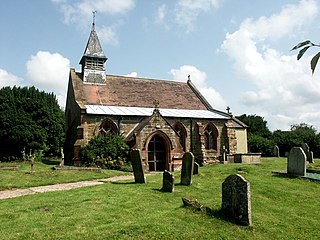
High Toynton is a village and civil parish in the East Lindsey district of Lincolnshire, England. It is situated approximately 1.5 miles (2.4 km) east from the town of Horncastle, and in the Lincolnshire Wolds, a designated Area of Outstanding Natural Beauty.
Hameringham is an extended village in the East Lindsey district of Lincolnshire, England. It is situated 4 miles (6.4 km) south-east from the town of Horncastle, and consists of High Hameringham and Low Hammeringham. It is in the civil parish of Lusby with Winceby.

Langton by Spilsby, sometimes called Langton by Partney, is a village and civil parish in the East Lindsey district of Lincolnshire, England. It is situated approximately 4 miles (6 km) north from the town of Spilsby, Lincolnshire. The civil parish includes the hamlet of Sutterby. From the 2011 census the population is included in the civil parish of Sausthorpe.

West Rasen is a village and civil parish in the West Lindsey district of Lincolnshire, England. It is situated on the A631 road, and approximately 3 miles (5 km) west from Market Rasen.
Button Snap is a 17th-century cottage in northeast Hertfordshire, that has been associated with the writer Charles Lamb. It is on a rural gravel road west of the village of Westmill. It has been listed Grade II on the National Heritage List for England since February 1967.

Housham Tye is a hamlet in the civil parish of Matching, and the Epping Forest district of Essex, England.
Clungunford is a civil parish in Shropshire, England. It contains 19 listed buildings that are recorded in the National Heritage List for England. Of these, two are listed at Grade II*, the middle of the three grades, and the others are at Grade II, the lowest grade. The parish contains the village of Clungunford, and the smaller settlements of Abcott and Beckjay, and is otherwise rural. Most of the listed buildings are houses, farmhouses and farm buildings, many of which are timber framed. The other listed buildings include a 14th-century church and a cross base in the churchyard, a bridge, and a country house.

Knowl Green is a hamlet in the civil parish of Belchamp St Paul and the Braintree district of Essex, England.

Staplecross is a village in the civil parish of Ewhurst and the Rother district of East Sussex, England. Staplecross is the largest settlement in Ewhurst parish, and is on a southern ridge of the valley of the River Rother which flows through Bodiam at the north of Staplecross. The village is in the High Weald Area of Outstanding Natural Beauty. In 2011 it had a population of 760.

Bristol Road in the City of Gloucester dates from the medieval period. It runs between Southgate Street in the north and Quedgeley in the south where it joins the Bath Road and the A38. It contains a number of listed buildings and other notable structures.
Anslow is a civil parish in the district of East Staffordshire, Staffordshire, England. The parish contains eight listed buildings that are recorded in the National Heritage List for England. All the listed buildings are designated at Grade II, the lowest of the three grades, which is applied to "buildings of national importance and special interest". The parish contains the village of Anslow and the surrounding countryside. The listed buildings consist of two small country houses and associated structures, a church, and a thatched cottage.
Kings Bromley is a civil parish in the district of Lichfield, Staffordshire, England. It contains 24 listed buildings that are recorded in the National Heritage List for England. Of these, one is at Grade I, the highest of the three grades, and the others are at Grade II, the lowest grade. The parish contains the village of Kings Bromley and the surrounding countryside. Most of the listed buildings are houses, cottages, farmhouses and farm buildings, many of which are timber framed or have timber framed cores, and some of the houses and cottages have thatched roofs. The Trent and Mersey Canal passes through the parish, and the listed buildings associated with it are two bridges, a lock, a lock keeper's cottage, and a milepost. The other listed buildings are a church, a churchyard cross, structures associated with a former manor house, and a war memorial.
Perton is a civil parish in the district of South Staffordshire, Staffordshire, England. It contains nine listed buildings that are recorded in the National Heritage List for England. All the listed buildings are designated at Grade II, the lowest of the three grades, which is applied to "buildings of national importance and special interest". The parish contains the village of Perton and an area to the northwest. The major building in the parish is Wrottesley Hall, which is listed, together with associated structures. The other listed buildings include a farmhouse, a cottage, a barn, a dovecote, and a milepost.

