
Tezpur is a city and urban agglomeration in Sonitpur district, Assam state, India. Tezpur is on the banks of the river Brahmaputra, 175 kilometres (109 mi) northeast of Guwahati, and is the largest of the north bank towns with a population exceeding 100,000 as per Metropolitan Census 2011.

Imphal is the capital city of the Indian state of Manipur. The metropolitan centre of the city contains the ruins of Kangla Palace, the royal seat of the former Kingdom of Manipur, surrounded by a moat.

Mahbub Nagar is a city in Mahbubnagar District of the Indian state of Telangana named after the 6th Nizam, Mir Mahbub Ali Khan. It is the headquarters of Mahbub Nagar mandal in Mahbub Nagar revenue division. The city is also the largest in the district with an area of 39.64 km2 (15.31 sq mi) and 7th most populous in the state.

Anantapur (officially:Anantapuramu) is a city in Anantapur district of the Indian state of Andhra Pradesh. It is the mandal headquarters of Anantapuramu mandal and also the divisional headquarters of Anantapur revenue division. The city is located on National Highway. It was also the headquarters of the Datta Mandalam in 1799. It was also a position of strategic importance for the British Indian Army during the Second World War.

Kurnool is the headquarters of Kurnool district. The city is often referred as The Gateway of Rayalaseema. As of 2011 census, it is the Fifth most populous city in the state with a population of 484,327. It is located at the banks of the Tungabhadra river.

Medak is a town in Medak district of the Indian state of Telangana. It is a municipality and the headquarters of Medak mandal in Medak revenue division.

Kothagudem is a city in Telangana state. Kothagudem is the headquarters of the Bhadradri Kothagudem district of the Indian state of Telangana.
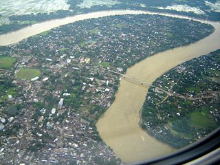
Silchar is the headquarters of Cachar district in the state of Assam in India. It is 343 kilometres (213 mi) south east of Guwahati.

Una is a Municipal Council City in Una district in the Indian state of Himachal Pradesh. It serves as the Headquater of Una district.There are 11 wards under Municipal Council .Una City is home to the Kila, which is a historical fort and an ancestral home of the descendants of the first guru of the Sikhs, Guru Nanak.

Hyderabad District is a district in the state of Telangana in India that contains a part of the metropolitan area of Hyderabad. It is headed by a district collector who is drawn from the IAS cadre and is appointed by the state government. It is the smallest of all the districts in the state, but has the highest human density. The district is a city district which means that it does not have a district headquarters. Old MCH area, which is central region of Hyderabad city comes under this district.

Bapatla is a town in Guntur district of the Indian state of Andhra Pradesh. It is a municipality and the mandal headquarters of Bapatla mandal of Tenali revenue division. The nearest towns and cities to Bapatla are Tenali ,Guntur, Chirala and Ponnur of 51km ,61km, 17km and 22km respectively .
Bhuntar is a town and a nagar panchayat in Kullu district in the state of Himachal Pradesh, India. Bhuntar Airport also known as Kullu airport, serves the town along with Kullu and Manali, is located here..At the confluence of the Parvati River with the River Beas, the Parvati Valley runs eastwards, through a steep-sided valley towards Kasol and Manikaran.

Narnaul is a city, a municipal council, and location of headquarters of the Mahendragarh district in the Indian state of Haryana. It is located in the National Capital Region of India.

North Lakhimpur is a town and a municipal board in Lakhimpur district in the Indian state of Assam, about 394 kilometres (245 mi) northeast of Guwahati. It is the district headquarters of Lakhimpur district.
Sundar Nagar is a town and a municipal council in Mandi district in the Indian state of Himachal Pradesh. Formerly it was a princely state, known as Suket.

Tuni is a town in East Godavari district of the Indian state of Andhra Pradesh. It is a major commercial marketing center for more than 40 surrounding villages in the district. Tuni is a border point for the district of East Godavari. It is known for mango export, with nearly 250 varieties. It is also famous for betel leaves and jute bags. A variety of cashew nuts are produced in Tuni.

Nandigama is a town in Krishna district of the Indian state of Andhra Pradesh. It is a Municipality and also the headquarters of Nandigama mandal in Vijayawada revenue division.

Kalingapatnam is a town in Srikakulam district of the Indian state of Andhra Pradesh. It is located in Gara mandal of Srikakulam revenue division. It has one of the major beach sand deposits of the state.

Kailashahar is a municipal council city, the headquarters of the Unakoti district in the Indian state of Tripura.

Long Island is an island of the Andaman Islands. It belongs to the North and Middle Andaman administrative district, part of the Indian union territory of Andaman and Nicobar Islands. the island is lying 80 km (50 mi) north from Port Blair.

