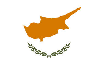
Cyprus, officially called the Republic of Cyprus, is an island country in the Eastern Mediterranean. The third largest and third most populous island in the Mediterranean, it is located south of Turkey; west of Syria and Lebanon; north of Egypt, Israel, and the Palestinian region of the Gaza Strip; and southeast of Greece.
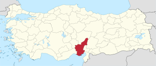
Adana Province, is a province of Turkey occupying the central Cilicia. With a population of 2.20 million, it is the sixth most populous province in Turkey. The administrative seat of the province is the city of Adana, home to 79% of the residents of the province. The province is closely affiliated with other Cilician provinces of Mersin, Osmaniye, and Hatay.

Turkey is divided into 81 provinces. Each province is divided into a number of different districts. Each provincial government is seated in the central district. The central district usually bears the name of the province. There are only three exceptions to this naming scheme:

Karabük Province is a landlocked province in the northern part of Anatolia, located about 200 km (124 mi) north of Ankara, 115 km (71 mi) away from Zonguldak and 113 km (70 mi) away from Kastamonu. In 2010 it had a population of 227,610. The main city is Karabük which is located about 100 km (62 mi) south of the Black Sea coast.

The Greco-Turkish War of 1919–1922 was fought between Greece and the Turkish National Movement during the partitioning of the Ottoman Empire in the aftermath of World War I, between May 1919 and October 1922.
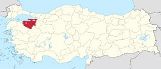
Bursa Province is a province in Turkey along the Sea of Marmara coast in northwestern Anatolia. It borders Balıkesir to the west, Kütahya to the south, Bilecik and Sakarya to the east, Kocaeli to the northeast and Yalova to the north. The province has an area of 11,043 km2 and a population of 2,994,521 as of 2018. Its traffic code is 16.
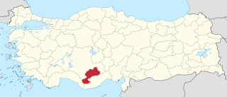
Karaman Province is a province of south-central Turkey. It has an area of 9,163 km2. It has a population of 232,633. According to the 2000 census the population was 243,210. Population density is 27.54 people/km2. The traffic code is 70. The capital is the city of Karaman. Karaman was the location of the Karamanid Beylik, which came to an end in 1486.

Afyonkarahisar Province, also called more simply Afyon Province, is a province in western Turkey.
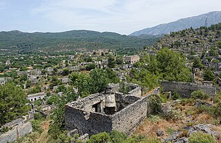
Kayaköy, anciently known in Greek as Karmilassos, shortened to Lebessos and pronounced in Modern Greek as Livissi, is presently a village 8 km south of Fethiye in southwestern Turkey in the old Lycia province. From Ancient Greek the town name shifted to Koine Greek by the Roman period, evolved into Byzantine Greek in the Middle Ages, and finally became the Modern Greek name still used by its townspeople before their final evacuation in 1923.

The Kurdish–Turkish conflict is an armed conflict between the Republic of Turkey and various Kurdish insurgent groups, which have demanded separation from Turkey to create an independent Kurdistan, or to have autonomy and greater political and cultural rights for Kurds inside the Republic of Turkey. The main rebel group is the Kurdistan Workers' Party or PKK. Although the Kurdish-Turkish conflict has spread to many regions, most of the conflict has taken place in Northern Kurdistan, which corresponds with southeastern Turkey. The PKK's presence in Iraqi Kurdistan has resulted in the Turkish Armed Forces carrying out frequent ground incursions and air and artillery strikes in the region, and its influence in Western Kurdistan has led to similar activity there. The conflict has cost the economy of Turkey an estimated $300 to 450 billion, mostly military costs. It has also affected tourism in Turkey.
A village is the smallest settlement unit in Turkey.
Belde means "large village with a municipality" in Turkish.

Operation Euphrates Shield was a cross-border military operation conducted by the Turkish Armed Forces and Turkey-aligned Syrian opposition groups in the Syrian civil war which led to the Turkish occupation of northern Syria. Operations were carried out in the region between the Euphrates river to the east and the Syrian rebel-held area around Azaz to the west. The Turkish military and Turkey-aligned Syrian rebel groups, some of which used the Free Syrian Army label, fought against both the Syrian Democratic Forces (SDF) and the Islamic State of Iraq and the Levant (ISIL), from 24 August 2016. On 29 March 2017, the Turkish military officially announced that Operation Euphrates Shield was "successfully completed".
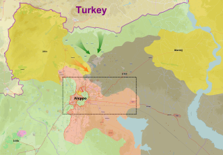
The northern al-Bab offensive was a military offensive and part of the third phase of Operation Euphrates Shield launched by the Turkish Armed Forces and factions from the Free Syrian Army and allied groups, with the goal of capturing the city of al-Bab located north of Aleppo from the Islamic State of Iraq and the Levant.

The 2016 Dabiq offensive was a military offensive and part of the third phase of Operation Euphrates Shield launched by the Turkish Armed Forces and factions from the Free Syrian Army and allied groups, with the goal of capturing the town of Dabiq, north of Aleppo from Islamic State in Iraq and the Levant (ISIL). It began in September and resulted in the capture of Dabiq by Turkish/FSA-allied forces on 16 October.

The western al-Bab offensive was a multi-sided military confrontation between the Syrian Army, the Syrian Democratic Forces (SDF), other (Turkey-backed) FSA factions, and the Islamic State of Iraq and the Levant in the countryside of northwestern Aleppo Governorate, south of the towns of Mare' and Tel Rifaat.

The Battle of al-Bab was a battle for the city of al-Bab in the Aleppo Governorate during the Syrian Civil War that included a military offensive launched by Syrian rebel groups and the Turkish Armed Forces north of al-Bab, a separate Syrian Democratic Forces (SDF) offensive east and west of the city, and another Syrian Army offensive from the south of the city. The northern Turkish-led forces intended to prevent the SDF taking al-Bab from the Islamic State of Iraq and the Levant (ISIL) by taking it themselves, as part of the Turkish military intervention in Syria. By the end of the battle, the Turkish-led forces had captured al-Bab, Qabasin, and Bizaah, while the Syrian Army captured Tadef and other areas further south, with the SDF making gains further to the east and the west.

The East Aleppo offensive (2017), also referred to as the Dayr Hafir offensive, was an operation launched by the Syrian Army to prevent Turkish-backed rebel forces from advancing deeper into Syria, and also to ultimately capture the ISIL stronghold of Dayr Hafir. Another aim of the operation was to gain control of the water source for Aleppo city, at the Khafsa Water Treatment Plant, in addition to capturing the Jirah Military Airbase. At the same time, the Turkish-backed rebel groups turned towards the east and started launching attacks against the Syrian Democratic Forces, west of Manbij.
The 2019 Tell Rifaat Clashes were a military confrontation between Turkey and allied Free Syrian Army groups against the Kurdish People's Protection Units (YPG) in early May 2019.

Fahrettin Koca is a Turkish physician and politician. He is the Minister of Health of the 66th government of Turkey. He is from Konya, Kulu, Tavşancalı village.


