
Çorum is a northern Anatolian city in Turkey. Çorum is located inland in the central Black Sea Region of Turkey and is approximately 244 km (152 mi) from Ankara and 608 km (378 mi) from Istanbul. It is the seat of Çorum Province and of Çorum District. Its population is 269,595 (2022). The city has an elevation of 801 m (2,628 ft) above sea level.

Bergama is a municipality and district of İzmir Province, Turkey. Its area is 1,544 km2, and its population is 105,754 (2022). By excluding İzmir's metropolitan area, it is one of the prominent districts of the province in terms of population and is largely urbanized at the rate of 53.6%. Bergama center is situated at a distance of 118 km (73 mi) to the north from the point of departure of the traditional center of İzmir and lies at a distance of 27 km (17 mi) inland from the nearest seacoast at the town of Dikili to its west. Bergama district area neighbors the areas of three districts of Balıkesir Province to its north, namely Ayvalık, Burhaniye and İvrindi, İzmir Province district of Kınık and Manisa Province district of Soma to its east, while to the south it is bordered by Yunusemre district of Manisa Province and two other İzmir Province districts along the coast that are Aliağa and Dikili from its south towards its west. The district area's physical features are determined by the alluvial plain of Bakırçay River.

Rize Province is a province of northeast Turkey, on the eastern Black Sea coast between Trabzon and Artvin. The province of Erzurum is to the south. Its area is 3,835 km2, and its population is 344,016 (2022). The capital is the city of Rize. It was formerly known as Lazistan, however the designation of the term of Lazistan was officially banned in 1926.
Tokat Province is a province in northern Turkey. Its area is 10,042 km2, and its population is 596,454 (2022). Its adjacent provinces are Amasya to the northwest, Yozgat to the southwest, Sivas to the southeast, and Ordu to the northeast. Its capital is Tokat, which lies inland of the middle Black Sea region, 422 kilometers from Ankara.

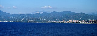
Rize is a coastal city in the eastern part of the Black Sea Region of Turkey. It is the seat of Rize Province and Rize District. Its population is 119,828 (2021). Rize is a typical Turkish provincial capital with little in the way of nightlife or entertainment. Since the border with Georgia was opened in the early 1990s, the Black Sea coast road has been widened and the town is much wealthier than it used to be. Current Turkish President Recep Tayyip Erdoğan's family has its roots in Rize and the local university is named after him. The city is linked by road with Trabzon, Hopa (55 miles [88 km] east on the Georgian border, and Erzurum. Rize–Artvin Airport started operating in 2022.
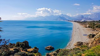
Antalya Province is a province and metropolitan municipality of Turkey. It is located on the Mediterranean coast of south-west Turkey, between the Taurus Mountains and the Mediterranean Sea. Its area is 20,177 km2, and its population is 2,688,004 (2022).
Tüfekçi is a neighbourhood of the municipality and district of Dernekpazarı, Trabzon Province, Turkey. Its population is 156 (2022).

Ordu or Altınordu is a port city on the Black Sea coast of Turkey, historically also known as Cotyora or Kotyora, and the capital of Ordu Province. The city forms the urban part of the Altınordu district, with a population of 235,096 in 2023.

Gümüşhane is a city in the Black Sea Region of Turkey. It is the seat of Gümüşhane Province and Gümüşhane District. Its population is 39,214 (2022). The city lies along the Harşit River, about 40 miles (64 km) southwest of Trabzon. The city lies at an elevation of 1,153 m (3,783 ft).

Merzifon is a town in Amasya Province in the central Black Sea region of Turkey. It is the seat of Merzifon District. Its population is 61,376 (2021). The mayor is Alp Kargı (CHP).
Espiye is a town in Giresun Province in the Black Sea region of Turkey. It is the seat of Espiye District. Its population is 26,671 (2022).
Ortaköy is a town in Çorum Province in the Black Sea region of Turkey, located at 57 km from the city of Çorum. It is the seat of Ortaköy District. Its population is 2,033 (2021). The mayor is Taner İsbir (AKP).

Alaca is a town in Çorum Province in the Black Sea region of Turkey. It is located 52 km (32 mi) from the city of Çorum, on a road from the Black Sea coast to central Anatolia. It is the administrative seat of Alaca District. Its population is 19,510 (2022).

Arhavi is a town in Artvin Province located in the Black Sea Region of Turkey. It is the seat of Arhavi District. Its population is 17,558 (2022), making it the third most populous municipality in Artvin Province. Laz people form a large portion of the population. The terrain is hilly and mountainous. Area of the city center is about 6 km2 (2.3 sq mi). The length of the coast is about 10 km (6.2 mi). Arhavi is famous by the Culture and Art Festival that celebrated since 1973.

Beyşehir is a municipality and district of Konya Province, Turkey. Its area is 2,054 km2, and its population is 77,690 (2022). The town is located on the southeastern shore of Lake Beyşehir and is marked to the west and the southwest by the steep lines and forests of the Taurus Mountains, while a fertile plain, an extension of the lake area, extends in the southeastern direction.

Fındıklı is a town in Rize Province on the Black Sea coast of Turkey, east of the city of Rize. It is the seat of Fındıklı District. Its population is 10,886 (2021).
Taşova is a town in Amasya Province of the central Black Sea region of Turkey. It is the seat of Taşova District. Its population is 11,248 (2021). The altitude of the town is 230 meters. The mayor is Bayram Öztürk (AKP).

Tekkeköy is a municipality and district of Samsun Province, Turkey. Its area is 326 km2, and its population is 56,318 (2022). It covers the easternmost part of the city of Samsun.

Ardanuç is a town in Artvin Province in Turkey's Black Sea region of Turkey, 32 km east of Artvin. The name Ardanuç derives from Lazuri language and Armenian. It is the seat of Ardanuç District. Its population is 5,470 (2021).

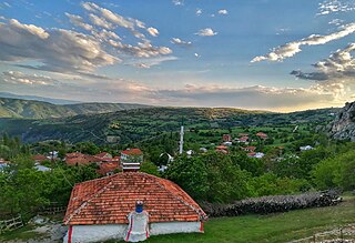
Zilkale is a medieval castle located in the Fırtına Valley within the Pontic Mountains, and is one of the most important historical structures in the Çamlıhemşin district of Rize Province, within the Black Sea Region of Turkey.
