
The Cook Islands is a self-governing island country in the South Pacific Ocean in free association with New Zealand. It comprises 15 islands whose total land area is 240 square kilometres (93 sq mi). The Cook Islands' Exclusive Economic Zone (EEZ) covers 1,960,027 square kilometres (756,771 sq mi) of ocean.
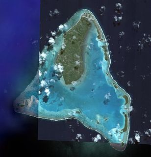
Aitutaki, also traditionally known as Araʻura and Utataki, is one of the Cook Islands, north of Rarotonga. It has a population of 1,712 in 2016. Aitutaki is the second most visited island of the Cook Islands. The main village is Arutanga (Arutunga) on the west side.

Tolaga Bay is both a bay and small town on the East Coast of New Zealand's North Island located 45 kilometres northeast of Gisborne and 30 kilometres south of Tokomaru Bay.

Manuae is an uninhabited atoll in the southern group of the Cook Islands, 100 kilometres south-east of Aitutaki. It is administratively part of Aitutaki, but it does not belong to any district or tapere of Aitutaki. It is, however, part of Arutanga-Reureu-Nikaupara Constituency.

Aiga-i-le-Tai is a district of Samoa which includes the small islands of Manono, Apolima and tiny uninhabited Nu'ulopa lying in the Apolima Strait between the country's two main islands of Upolu and Savai'i.

North Rustico is a Canadian town located in Queens County, Prince Edward Island.

Murray Harbour is a municipality that holds rural municipality status in Prince Edward Island, Canada. It is located in southeastern Kings County.

Muritapua is one of 22 islands in the Aitutaki atoll of the Cook Islands. It is a small islet located on the eastern perimeter of Aitutaki Lagoon between the larger islands of Akaiami and Tekopua, six kilometres to the southeast of the main island of Aitutaki. The island is 360m long and 150m wide.
Tekopua is one of 22 islands in the Aitutaki atoll of the Cook Islands. It is located on the southeastern perimeter of Aitutaki Lagoon between the smaller islands of Muritapua and Tapuaetai, seven kilometres to the southeast of the main island of Aitutaki. It is the largest of the Aitutaki motu, measuring 2250m long and up to 480m wide.
Moturakau is one of 22 islands in the Aitutaki atoll of the Cook Islands. It is located in the southeast of Aitutaki Lagoon between the larger islands of Rapota and Tekopua, six kilometres to the southeast of the main island of Aitutaki. The island is 460m long and 120m wide. Moturakau served as a leper colony from the 1930s to 1967. More recently, it was home to the 'Sharks' for four years of the UK reality TV programme Shipwrecked: Battle of the Islands.
Rapota is one of 22 islands in the Aitutaki atoll of the Cook Islands. It is located in the south of Aitutaki Lagoon to the west of the smaller island of Moturakau, six kilometres to the southeast of the main island of Aitutaki. The island is volcanic, with a core of basalt surrounde dby basalt boulders.

Maina is one of 22 islands in the Aitutaki atoll of the Cook Islands. It is located at the southwestern extreme of Aitutaki Lagoon, five kilometres to the southwest of the main island of Aitutaki. The island is a sand cay 710m long and up to 310m wide. In front of Maina island stands a sandbar known as "Honeymoon Island" named after a Canadian couple who decided to get married here.
Papau is one of 22 islands in the Aitutaki atoll of the Cook Islands. It is located on the eastern perimeter of Aitutaki Lagoon, four kilometres to the east of the main island of Aitutaki. The island is 400m long and 200m wide.
Indian Bay is located in Newfoundland, Canada.
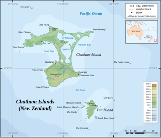
Owenga is a small settlement on Chatham Island, in New Zealand's Chatham Islands group. It is the second easternmost settlement in New Zealand, after Flower Pot Bay on Pitt Island. It is located in the southeast of the island, close to Cape Fournier.
A Tapere or Sub-District is a low level of traditional land subdivision on five of the Lower Cook Islands, comparable to the ahupua'a of the main Hawaiian Islands. Among the populated raised islands, only Mitiaro is not subdivided into tapere. The remaining southern Cook Islands, Manuae, Palmerston and Takutea are atolls and/or uninhabited, and therefore not subject to this type of traditional subdivision. The atolls of the northern Cook Islands are subdivided into motu, instead.
Teina Bishop is a Cook Islands politician, former Cabinet Minister, and leader of the One Cook Islands Movement. He was jailed for corruption in 2016.
The Arutanga by-election was a by-election in the Cook Islands seat of Arutanga-Reureu-Nikaupara. It took place on 20 November 2003.

Division No. 1, Subdivision G is an unorganized subdivision on the Avalon Peninsula in Newfoundland and Labrador, Canada. It is in Division 1 and contains the unincorporated communities of Baccalieu Island, Besom Cove, Bradley's Cove, Burnt Point, Caplin Cove, Daniel's Cove, Grates Cove, Gull Island, Job's Cove, Kingston, Long Beach, Lower Island Cove, Low Point, Northern Bay, Ochre Pit Cove, Red Head Cove, Riverhead, Smooth Cove and Western Bay.

The USS YP-72 (ex-Cavalcade) was a converted fishing vessel which served as an auxiliary patrol boat in the U.S. Navy during World War II.
