Nkroful is a village in the Ellembelle District, a district in the Western Region of south Ghana, located near Axim in the Nzema East Municipal of the Western Region.
Kaba is a town in eastern Hungary, in the county of Hajdú-Bihar. The town is located along the Hungarian Route 4, approximately 190 km from Budapest, the capital city and 32 km west from Debrecen, the county seat.

Alunite is a hydroxylated aluminium potassium sulfate mineral, formula KAl3(SO4)2(OH)6. It was first observed in the 15th century at Tolfa, near Rome, where it was mined for the manufacture of alum. First called aluminilite by J.C. Delamétherie in 1797, this name was contracted by François Beudant three decades later to alunite.

Mindat.org is a non-commercial online database, claiming to be the largest mineral database and mineralogical reference website on the Internet. It is used by professional mineralogists, geologists, and amateur mineral collectors alike.
Emekeobibi is a village in southeastern Nigeria; it is located near the city of Owerri.
Ekwerazu Ogwa is a village in southeastern Nigeria. Also, it is located near the city of Owerri.
Ihitte Ogwa is a village in southeastern Nigeria located near the city of Owerri, Imo State.
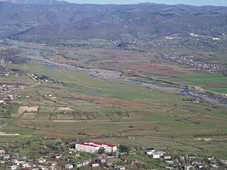
The Qvirila is a river of Georgia. It is 140 km (87 mi) long, and has a drainage basin of 3,630 km2 (1,400 sq mi). It is a left affluent of the Rioni, which it joins south of the city Kutaisi.

Ilium or Ilion, also known as Troja (Τροΐα), was a city of ancient Epirus. It is mentioned in the Aeneid of Virgil as a foundation of Helenus after the Trojan War in the land of the Chaonia.
Saattoq Island is an island of Greenland. It is located in Baffin Bay in the Upernavik Archipelago.
The Lukuledi is a river in The United Republic Of Tanzania, south-eastern region of Africa. With a total length of 160 km, it rises from the boundary between the Lindi and Mtwara regions.

Ellembelle District is one of the fourteen districts in Western Region, Ghana. Originally it was formerly part of the then-larger Nzema East District in 1988, which was created from the former Nzema District Council, until the western part of the district was split off by a decree of then-president John Agyekum Kufuor on 29 February 2008 to create Ellembelle District; thus the remaining part has been retained as Nzema East District. The district assembly is located in the southwest part of Western Region and has Nkroful as its capital town.

The Kupferschiefer or Kupfermergel, is an extensive and remarkable sedimentary unit in Central Europe. The relatively monotonous succession is typically 30 to 60 centimetres and maximum 2 metres (6.6 ft) thick, but extends over an area of 600,000 square kilometres (230,000 sq mi) across the Southern Permian Basin. The Kupferschiefer can be found in outcrop or in the subsurface straddling six countries, including parts of the southern North Sea. The lateral equivalent outcropping in England is called Marl Slate.

The Clara Pit or Clara Mine is a working mine in Oberwolfach in the Black Forest in Germany in which the industrial minerals, baryte and fluorspar are mined.
Zeolites are found in several locations in southern and central Idaho.

The sulfate carbonates are a compound carbonates, or mixed anion compounds that contain sulfate and carbonate ions. Sulfate carbonate minerals are in the 7.DG and 5.BF Nickel-Strunz groupings.
Razanaka or Vohipeno Razanaka is a rural municipality in the Brickaville district in the Atsinanana Region, Madagascar.
Lohariandava is a village and commune in the Brickaville district in the Atsinanana Region, Madagascar.
Ambolotarakely is a municipality in Analamanga Region, in the Central Highlands of Madagascar, located in the North from the capital of Antananarivo. Ambolotarakely is situated in Ankazobe, Antananarivo, Madagascar, its geographical coordinates are 18° 16' 0" South, 47° 24' 0" East.
